- Home
- :
- All Communities
- :
- Developers
- :
- ArcGIS REST APIs and Services
- :
- ArcGIS REST APIs & Services Ques.
- :
- Re: [NewBee] Convert X Y to Lat Long Programmatica...
- Subscribe to RSS Feed
- Mark Topic as New
- Mark Topic as Read
- Float this Topic for Current User
- Bookmark
- Subscribe
- Mute
- Printer Friendly Page
[NewBee] Convert X Y to Lat Long Programmatically (or Free)
- Mark as New
- Bookmark
- Subscribe
- Mute
- Subscribe to RSS Feed
- Permalink
- Report Inappropriate Content
Hello All,
Today is the first day I heard about ArcGIS so please bear with me. I am a javascript developer trying to build a hobby project. I was looking for a list of all trailheads in Washington state and found this CSV
https://hub.arcgis.com/datasets/wa-geoservices::watrailheads-all/about
I downloaded it and it gave me exactly what I was looking for (yay!). However instead of giving me latitude and longitude it gave me arcgis X and Y values.
is there an API which will convert this to a normal lat and long which can be used by google maps?
Please bear with me. I don't have any money to buy arcgis. so please help me how can I achieve that I am trying to do.
Or perhaps is there a way I can install a "free" tool on my Mac which will import this CSV and export another one with lat/long?
Edit:: So I googled a lot and based on everything I found I wrote this python program
from arcgis.gis import GIS
from arcgis.geocoding import reverse_geocode
from arcgis.geometry import from_geo_coordinate_string
gis = GIS()
location = [-118.504999000172, 48.505501999717]
 new_location = reverse_geocode(location)
 print(new_location)
But the output still contains X,Y and not Lat Long.
{'address': {'Match_addr': 'East Fork Hall Creek Rd, Boyds, Washington, 99107', 'LongLabel': 'East Fork Hall Creek Rd, Boyds, WA, 99107, USA', 'ShortLabel': 'East Fork Hall Creek Rd', 'Addr_type': 'StreetName', 'Type': '', 'PlaceName': '', 'AddNum': '', 'Address': 'East Fork Hall Creek Rd', 'Block': '', 'Sector': '', 'Neighborhood': '', 'District': '', 'City': 'Boyds', 'MetroArea': '', 'Subregion': 'Ferry County', 'Region': 'Washington', 'RegionAbbr': 'WA', 'Territory': '', 'Postal': '99107', 'PostalExt': '', 'CntryName': 'United States', 'CountryCode': 'USA'}, 'location': {'x': -118.50505046182948, 'y': 48.50548769016435, 'spatialReference': {'wkid': 4326, 'latestWkid': 4326}}}
>>>
Solved! Go to Solution.
Accepted Solutions
- Mark as New
- Bookmark
- Subscribe
- Mute
- Subscribe to RSS Feed
- Permalink
- Report Inappropriate Content
Hi Abhishek,
I've just downloaded a csv from the open data site you linked and despite the fields being labelled x/y those are latitudes and longitudes (x=longitude, y=latitude).
And in the reverse geocode example you posted the results are in WGS84 (WKID4326) which is latitude and longitude. You can plug them into google maps and it will work, I've done this with the top row of the csv below
- Mark as New
- Bookmark
- Subscribe
- Mute
- Subscribe to RSS Feed
- Permalink
- Report Inappropriate Content
I played around with the UI and saved the map given by the government into my own folder https://services.arcgis.com/jsIt88o09Q0r1j8h/arcgis/rest/services/WATrailheads_All/FeatureServer
Now I need to somehow covert X,Y to Lat, Long and then download CSV.
- Mark as New
- Bookmark
- Subscribe
- Mute
- Subscribe to RSS Feed
- Permalink
- Report Inappropriate Content
Hi Abhishek,
I've just downloaded a csv from the open data site you linked and despite the fields being labelled x/y those are latitudes and longitudes (x=longitude, y=latitude).
And in the reverse geocode example you posted the results are in WGS84 (WKID4326) which is latitude and longitude. You can plug them into google maps and it will work, I've done this with the top row of the csv below
- Mark as New
- Bookmark
- Subscribe
- Mute
- Subscribe to RSS Feed
- Permalink
- Report Inappropriate Content
Thanks so much. I was interpreting it as X = latitude and Y and longitude and it was not working for me. Yes what you say totally makes sense.
- Mark as New
- Bookmark
- Subscribe
- Mute
- Subscribe to RSS Feed
- Permalink
- Report Inappropriate Content
No worries, glad I could help out mate!
- Mark as New
- Bookmark
- Subscribe
- Mute
- Subscribe to RSS Feed
- Permalink
- Report Inappropriate Content
Hi @AbhishekSrivastava2, regarding to this:
...Please bear with me. I don't have any money to buy arcgis. so please help me how can I achieve that I am trying to do.Or perhaps is there a way I can install a "free" tool on my Mac which will import this CSV and export another one with lat/long?...
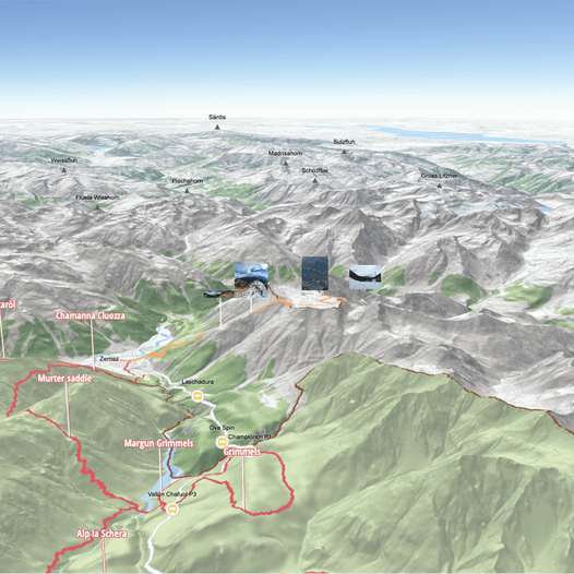
I just wanted to let you know that as a developer, you can also create a free account with a generous free tier (+$300/month currently) 😉, and with that soon you will be able to use the new outdoors basemap that was presented a few weeks ago which I think will fit pretty well that dataset 😁.
And remember you can use it with our Maps SDK for JS to build cool visualization like this hiking map:
Or any of the other open source libraries (Leaflet, MapLibre, ...)
I hope this helps!
- Mark as New
- Bookmark
- Subscribe
- Mute
- Subscribe to RSS Feed
- Permalink
- Report Inappropriate Content
wow!!!! nice. thanks for this.


