Turn on suggestions
Auto-suggest helps you quickly narrow down your search results by suggesting possible matches as you type.
Cancel
- Home
- :
- All Communities
- :
- Developers
- :
- Native Maps SDKs
- :
- Runtime SDK WPF (Retired) Ques
- :
- Draw a circle with width in meter
Options
- Subscribe to RSS Feed
- Mark Topic as New
- Mark Topic as Read
- Float this Topic for Current User
- Bookmark
- Subscribe
- Mute
- Printer Friendly Page
Draw a circle with width in meter
Subscribe
04-03-2014
12:25 AM
- Mark as New
- Bookmark
- Subscribe
- Mute
- Subscribe to RSS Feed
- Permalink
- Report Inappropriate Content
Hi everyone,
I would like to draw a circle on a point with width in meter.
To do that, I've tried to use the scale of the map.
Assuming that scale = ft / pixel (i'm not sure that this formula is correct)
And ft = m * 3.2808
sizeInPixel = sizeInMeter / MyMap.Scale * 3.2808;
To draw the circle I use a class inheriting from polygon :
And to define the width of my crircle :
But it doesn't works And the size change when I try to recalculate it on a zoom/dezoom
When I zoom in :
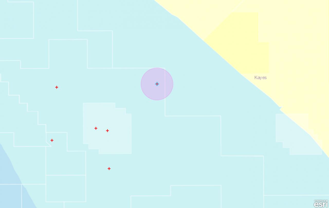
[ATTACH=CONFIG]32760[/ATTACH]
When I zoom out :
[ATTACH=CONFIG]32761[/ATTACH]
Thanks
I would like to draw a circle on a point with width in meter.
To do that, I've tried to use the scale of the map.
Assuming that scale = ft / pixel (i'm not sure that this formula is correct)
And ft = m * 3.2808
sizeInPixel = sizeInMeter / MyMap.Scale * 3.2808;
To draw the circle I use a class inheriting from polygon :
public class Circle : Polygon { private double radius = double.NaN; private MapPoint center = null; private int pointCount = 360; public double Radius { get { return radius; } set { radius = value; CreateRing(); } } [System.ComponentModel.TypeConverter(typeof(MapPointConverter))] public MapPoint Center { get { return center; } set { center = value; CreateRing(); } } public int PointCount { get { return pointCount; } set { pointCount = value; CreateRing(); } } private void CreateRing() { this.Rings.Clear(); if (!double.IsNaN(Radius) && Radius > 0 && Center != null && PointCount > 2) { PointCollection pnts = new PointCollection(); for (int i = 0; i <= PointCount; i++) { double rad = 2 * Math.PI / PointCount * i; double x = Math.Cos(rad) * radius + Center.X; double y = Math.Sin(rad) * radius + Center.Y; pnts.Add(new MapPoint(x, y)); } this.Rings.Add(pnts); } } }And to define the width of my crircle :
var buffer = new _2gDataRoomViewer.MyGeoms.Circle(); buffer.Center = new MapPoint(lon, lat); buffer.Radius = bufferSize / (MyMap.Scale * 3.2808);//bufferSize is the width in meter GraphicsLayer bufferPuitsLayer = MyMap.Layers["BufferPuitsLayer"] as GraphicsLayer; var symbol = new SimpleFillSymbol(); symbol.BorderThickness = 3; SolidColorBrush color = new SolidColorBrush(Colors.Violet); symbol.Fill = color; symbol.Fill.Opacity = 0.3; symbol.BorderBrush = color; Graphic graphic = new Graphic() { Geometry = mercator.FromGeographic(buffer), Symbol = symbol }; bufferPuitsLayer.Graphics.Add(graphic);But it doesn't works And the size change when I try to recalculate it on a zoom/dezoom
When I zoom in :
[ATTACH=CONFIG]32760[/ATTACH]
When I zoom out :
[ATTACH=CONFIG]32761[/ATTACH]
Thanks
Solved! Go to Solution.
1 Solution
Accepted Solutions
by
Anonymous User
Not applicable
04-03-2014
11:27 PM
- Mark as New
- Bookmark
- Subscribe
- Mute
- Subscribe to RSS Feed
- Permalink
- Report Inappropriate Content
Original User: nviot64
I've resolved my problem.
The mather was that I tried to define a distance in meter in a WGS84 spatial reference.
Assuming that 1km is aproximatively equals to 0.00901 "degré décimal" (in french) I've done this formula :
buffer.Radius = (bufferSize / 1000) * 0.00901;
And it works !
I've resolved my problem.
The mather was that I tried to define a distance in meter in a WGS84 spatial reference.
Assuming that 1km is aproximatively equals to 0.00901 "degré décimal" (in french) I've done this formula :
buffer.Radius = (bufferSize / 1000) * 0.00901;
And it works !
2 Replies
04-03-2014
11:18 PM
- Mark as New
- Bookmark
- Subscribe
- Mute
- Subscribe to RSS Feed
- Permalink
- Report Inappropriate Content
The better approach would be to take the center of your point, apply a buffer on this (in meters) and draw this graphic. You shouldn't be concerned with pixel size, etc.
Open the ArcGIS Runtime Samples application. There is an example called "Buffer" that does exactly what you want.
Open the ArcGIS Runtime Samples application. There is an example called "Buffer" that does exactly what you want.
by
Anonymous User
Not applicable
04-03-2014
11:27 PM
- Mark as New
- Bookmark
- Subscribe
- Mute
- Subscribe to RSS Feed
- Permalink
- Report Inappropriate Content
Original User: nviot64
I've resolved my problem.
The mather was that I tried to define a distance in meter in a WGS84 spatial reference.
Assuming that 1km is aproximatively equals to 0.00901 "degré décimal" (in french) I've done this formula :
buffer.Radius = (bufferSize / 1000) * 0.00901;
And it works !
I've resolved my problem.
The mather was that I tried to define a distance in meter in a WGS84 spatial reference.
Assuming that 1km is aproximatively equals to 0.00901 "degré décimal" (in french) I've done this formula :
buffer.Radius = (bufferSize / 1000) * 0.00901;
And it works !