- Home
- :
- All Communities
- :
- Products
- :
- ArcGIS Spatial Analyst
- :
- ArcGIS Spatial Analyst Questions
- :
- Calculating area of pixles for certain Aspect valu...
- Subscribe to RSS Feed
- Mark Topic as New
- Mark Topic as Read
- Float this Topic for Current User
- Bookmark
- Subscribe
- Mute
- Printer Friendly Page
Calculating area of pixles for certain Aspect value per specific area?
- Mark as New
- Bookmark
- Subscribe
- Mute
- Subscribe to RSS Feed
- Permalink
- Report Inappropriate Content
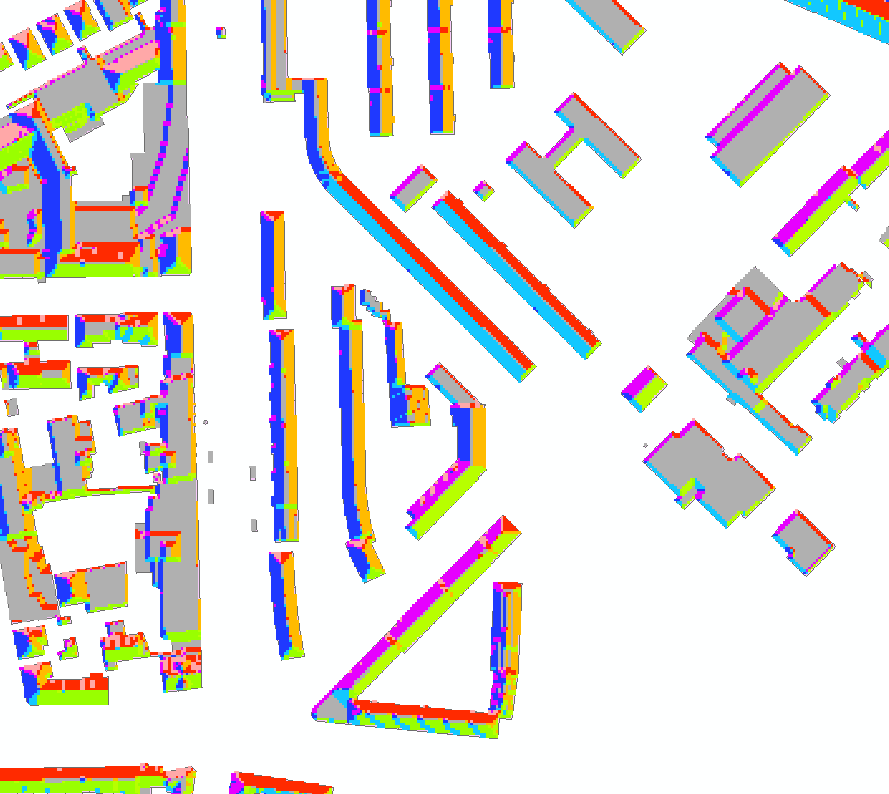
I have the aspect (raster file) for the roof of buildings at the city scale. Now I want to calculate the area of each aspect group per building. I tied zonal statistics, zonal geometry and etc . Also reclassified the aspect layer and tried to add the Building ID. But I didn't get the desired result. Is there a way to do that? Kindly see the attached
- Mark as New
- Bookmark
- Subscribe
- Mute
- Subscribe to RSS Feed
- Permalink
- Report Inappropriate Content
to do it on a per building basis you need the individual 'zones' which can be accomplished using.
Region Group—Help | ArcGIS Desktop
the resultant would be your zone file, then a zonal count would give you the number of cells (times cell area) per aspect by building
- Mark as New
- Bookmark
- Subscribe
- Mute
- Subscribe to RSS Feed
- Permalink
- Report Inappropriate Content
You should also read this blog post...
- Mark as New
- Bookmark
- Subscribe
- Mute
- Subscribe to RSS Feed
- Permalink
- Report Inappropriate Content
Thanks Dan! I performed the region group, then displayed with the link value (shows exact values as for aspect.tif). Also did zonal statistic with the feature zone as the regiongroup.shp + the zone filed as count+ value raster (uploaded aspect.tif). But still didn't get the desired result . I think I am missing something , can you please illustrate the second step in more detail.
- Mark as New
- Bookmark
- Subscribe
- Mute
- Subscribe to RSS Feed
- Permalink
- Report Inappropriate Content
need to see what your desired result is in light of what you have.. it may need an interpretation suggestion or modification
- Mark as New
- Bookmark
- Subscribe
- Mute
- Subscribe to RSS Feed
- Permalink
- Report Inappropriate Content
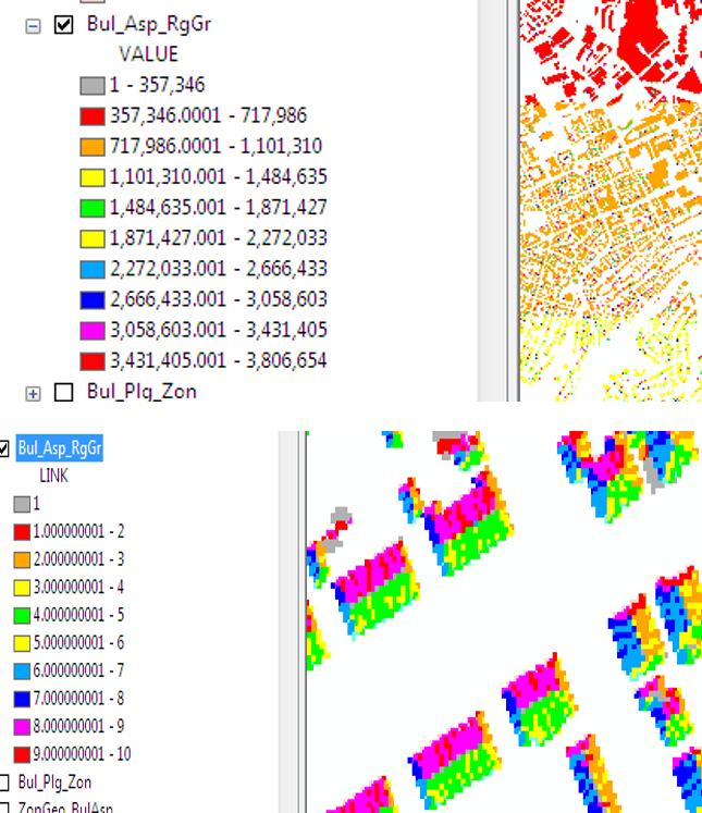
After visualizing the product of Region Group , it seems that it is not giving the zone needed (top classification by value bottom classification by Link).
- Mark as New
- Bookmark
- Subscribe
- Mute
- Subscribe to RSS Feed
- Permalink
- Report Inappropriate Content
something doesn't look right. You need to regiongroup your original zones. Then you use that for the zonal statistics on your aspect. You don't regiongroup the aspect
- Mark as New
- Bookmark
- Subscribe
- Mute
- Subscribe to RSS Feed
- Permalink
- Report Inappropriate Content
Thank you for your time! I do agree with you, but I did regiongroup for the building footprint first but it didn't give what I needed. That is why in the second attempt I did the regiongroup for Aspect. It is worth to mention that both layers follow the same grouping pattern when I reclassify the value, with the exception of the No. of elements in the attribute table -which are different- .
- Mark as New
- Bookmark
- Subscribe
- Mute
- Subscribe to RSS Feed
- Permalink
- Report Inappropriate Content
regiongroup produces the zones for zonal statistics operations.
now you need to do the zonal statistics
I notice that you have an incredibly large number of zones, suggesting that your input raster wasn't cleaned up and you probably have a whole load of zones that consist of 1 or 2 cells. You could use nibble to fill those in with adjoining values, but I suggest that it might be worthwhile getting a clean vector file of the building footprints and start the zonal statistics from that