- Home
- :
- All Communities
- :
- Products
- :
- ArcGIS Spatial Analyst
- :
- ArcGIS Spatial Analyst Questions
- :
- DEM values/DEM differencing
- Subscribe to RSS Feed
- Mark Topic as New
- Mark Topic as Read
- Float this Topic for Current User
- Bookmark
- Subscribe
- Mute
- Printer Friendly Page
DEM values/DEM differencing
- Mark as New
- Bookmark
- Subscribe
- Mute
- Subscribe to RSS Feed
- Permalink
- Report Inappropriate Content
Hi everyone,
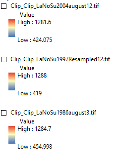
I would like to compare the elevation and volume of three DEMs. When I export the original DEMs in TIFF format the elevation values change. I do not use compression or any other kind of data transformation. It makes me wonder what the real elevation values are.
Before
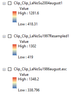
After
My second question is that I have calculated the volume difference of my DEMs (not the TIFF versions but the original) and it says that there is an increase in total volume between the DEMs. It is nearly impossible, since these are glacier surfaces that are known to decline in this area (and in most parts of the World). It is unlikely that there is a snow bias and my DEMs are in the same coordinate system and all clipped to the same vector shape.
Any idea what could have gone wrong?
Thanks
Laz
- Mark as New
- Bookmark
- Subscribe
- Mute
- Subscribe to RSS Feed
- Permalink
- Report Inappropriate Content
Any chance the cell size varies between your files? This might account for the volume difference.
Also, when you are doing any processing, is a Snap Raster being set in the Environments setting?
ArcGIS Help (10.2, 10.2.1, and 10.2.2)
Chris Donohue, GISP
- Mark as New
- Bookmark
- Subscribe
- Mute
- Subscribe to RSS Feed
- Permalink
- Report Inappropriate Content
Hi Chris,
Its not the cells size, they are all in agreement. I'll try the Snap Raster though, however, looking at properties, all my DEMs are identical, from cell size through pixel type and format.
I'll keep on experimenting.
Thanks a lot,
Laszlo
- Mark as New
- Bookmark
- Subscribe
- Mute
- Subscribe to RSS Feed
- Permalink
- Report Inappropriate Content
did you check the cell size and the extents explicitly in your environments prior to export? Any change in cell size and/or extent could be fully or partially to count. Your will have to compare your rasters after conversion to ensure that they are indeed the same
- Mark as New
- Bookmark
- Subscribe
- Mute
- Subscribe to RSS Feed
- Permalink
- Report Inappropriate Content
Hi Dan,
Thanks for your reply. I resapmled my DEMs to the same resolution(25x25m) before processing them. I have defined the spatial extent myself, by clipping the DEMs to a vector outline through the Image Analysis menu.
My other problem is that when I turn these three DEMs into contour maps two of them doesn't draw. I have imported the third DEM's Coordinate system, also the 'project' tool and tried several other systems, nothing works, whereas they all show up correctly before turning them into contour maps.
Ideally, all layers should be in the same coordinate system, but somehow it is just not possible in my case. For instance, my vector files are in 1993 Lambert system and my Landsat images are in WGS 1984. They perfectly overlap this way, but if I change my vector to WGS 1984 it won't draw. I have been using ArcMap actively for a year by now, performing different tasks but i still can't figure out why this is happening.
Any idea?
Many thanks,
Laszlo
- Mark as New
- Bookmark
- Subscribe
- Mute
- Subscribe to RSS Feed
- Permalink
- Report Inappropriate Content
You don't 'change' coordinate systems, you 'project' a files, which produces a new file with the desired coordinate system. If you are using the 'define projection' tool anywhere in your process to try and accomplish what you are trying to do, you will end up with files that don't align, overlap and are not in the same coordinate space. The only time that the 'define projection' tool should ever be used is when you get a warning that your file does not have a defined coordinate system. If you got no such warning, then you are not doing what you need to do.
So... get your data into one coordinate system, via using the Project tool for vector data or Project Raster for raster data.
Once everything is in the correct coordinate system, you can begin
- Mark as New
- Bookmark
- Subscribe
- Mute
- Subscribe to RSS Feed
- Permalink
- Report Inappropriate Content
That's right, but it doesn't explain why the contour maps don't draw. They are in the same projection.
Also, I tried the above Project Raster tool. Usually I get error messages when performing tasks for no apparent reason. Here is the latest one when trying to project raster:

- Mark as New
- Bookmark
- Subscribe
- Mute
- Subscribe to RSS Feed
- Permalink
- Report Inappropriate Content
that one is easy... turn off background geoprocessing, it is more trouble that it is worth
- Mark as New
- Bookmark
- Subscribe
- Mute
- Subscribe to RSS Feed
- Permalink
- Report Inappropriate Content
and if the contours don't appear, make sure they are on top of the list, right-click on the layer, zoom to layer and see if it is in the same coordinate space. If it isn't, there is something wrong with the coordinate systems, like perhaps trying to contour data which are in geographic coordinates
- Mark as New
- Bookmark
- Subscribe
- Mute
- Subscribe to RSS Feed
- Permalink
- Report Inappropriate Content
I switched off background geoprocessing. The overall performance seems to have improved but I got the same error message while projecting raster.