- Home
- :
- All Communities
- :
- Products
- :
- ArcGIS Spatial Analyst
- :
- ArcGIS Spatial Analyst Questions
- :
- Re: Spatial Analyst InList tool appears to have a ...
- Subscribe to RSS Feed
- Mark Topic as New
- Mark Topic as Read
- Float this Topic for Current User
- Bookmark
- Subscribe
- Mute
- Printer Friendly Page
Spatial Analyst InList tool appears to have a bug in 10.5 and 10.5.1
- Mark as New
- Bookmark
- Subscribe
- Mute
- Subscribe to RSS Feed
- Permalink
- Report Inappropriate Content
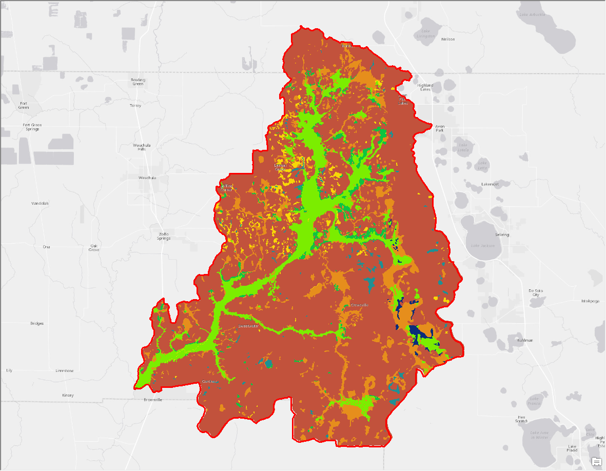
The Spatial Analyst > Math > Logical > InList tool appears to have a bug in 10.5 that was not present in 10.3. The result of the InList seems to ignore the NoData areas of the input raster. Here is the input layer (soils) that shows NoData values outside of the red boundary.
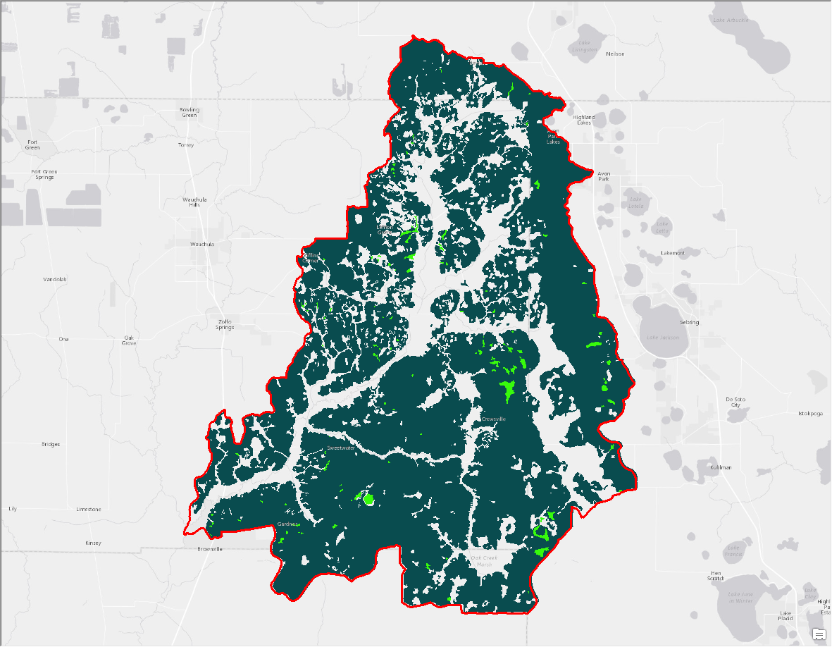
Here is the result of the InList tool from ArcGIS 10.3.1 - notice the NoData values outside the boundary.
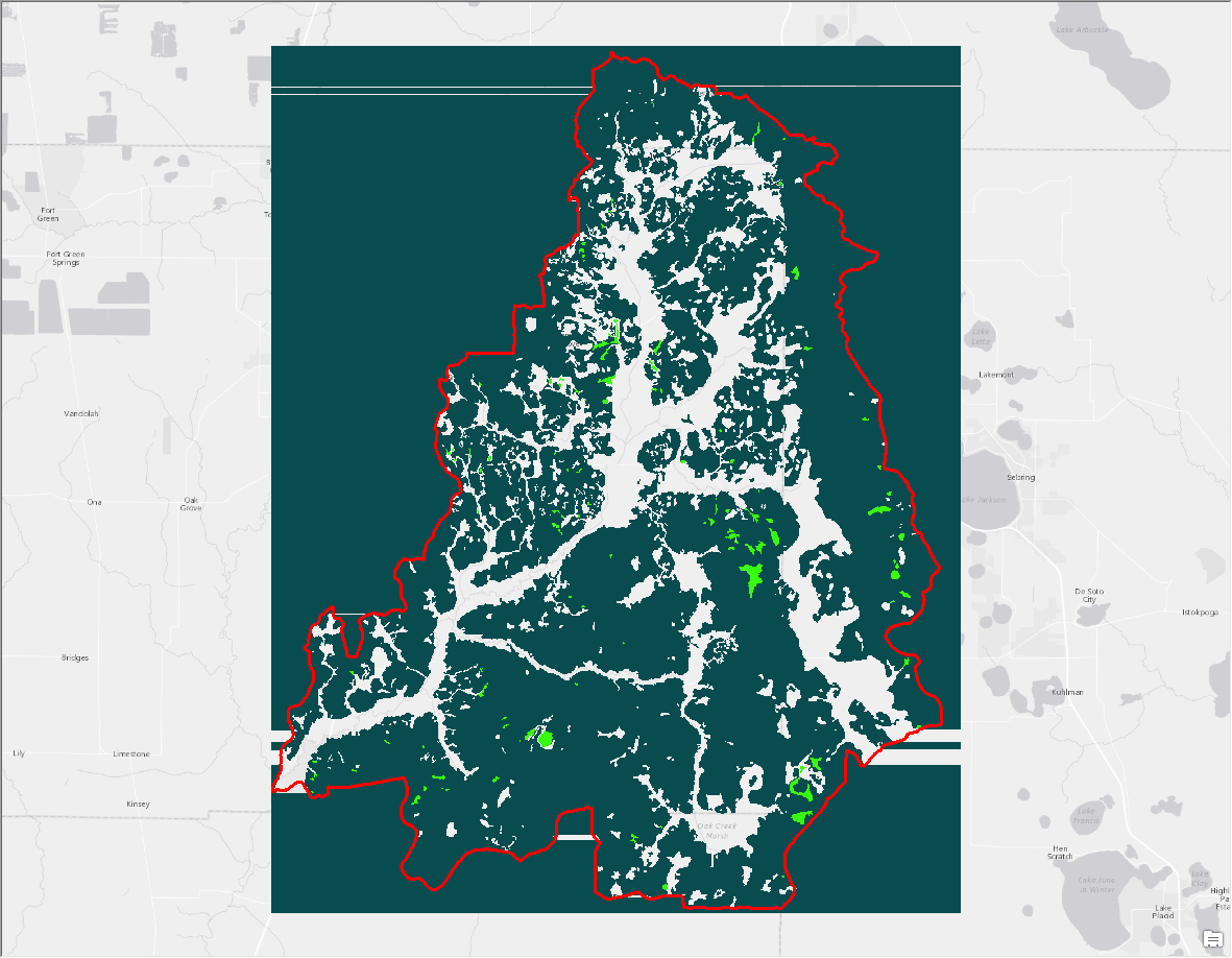
Here is the result in 10.5.1 (10.5 produced the same result). Notice the result seems to extend the pixel values at the edge of the boundary to the edge of the raster extent.
I know that the easy solution is to clip the layer, or use the reclassify tool instead of the InList, but I am wondering if there is something that I am doing wrong. I've tried making a new copy of the input, changing the projections, etc.
- Mark as New
- Bookmark
- Subscribe
- Mute
- Subscribe to RSS Feed
- Permalink
- Report Inappropriate Content
report it... that shouldn't happen and it appears you have verifiable example data.
- Mark as New
- Bookmark
- Subscribe
- Mute
- Subscribe to RSS Feed
- Permalink
- Report Inappropriate Content
Thanks. Sorry for my ignorance, but where do we report bugs like this?
- Mark as New
- Bookmark
- Subscribe
- Mute
- Subscribe to RSS Feed
- Permalink
- Report Inappropriate Content
Follow the Support links at the top of your page, if you are the sole maintainer of your software. If you belong to an organization, they may have a report person, but anyone can file a support case, just report what you have found and they should request a zipped copy of the data etc at some stage.
- Mark as New
- Bookmark
- Subscribe
- Mute
- Subscribe to RSS Feed
- Permalink
- Report Inappropriate Content
Hello Shawn, thanks for reporting that. Have you contacted Support and report the bug yet? If so did you got the issue number? You can give me that number directly and I will investigate.
Actually, I have tried my own data but cannot reproduce the bug. So I need more detailed information about your data and steps.
- Mark as New
- Bookmark
- Subscribe
- Mute
- Subscribe to RSS Feed
- Permalink
- Report Inappropriate Content
Hello,
I reported it today, it was investigated, and a bug was reported.
Thanks,
Shawn
Hello Shawn,
Thank you for reporting the issue and sending your data and screenshot.
I was able to reproduce the issue and proceeded to log the below bug:
BUG-000108147: InList tool wrongly assigns values outside the raster boundary
Steps to Reproduce:
1. Download the data.
2. Open Arcmap > Open 'Inlist' tool
3. Add firstb_reclassified_copy.tiff as input raster
4. Add values 4, 5, and 6 as 'constant values'
5. Notice how the tool wrongly assigns values outside the raster boundary.
6. See video: https://screencast-o-matic.com/watch/cbQqbLIruA
7. Issue does not occur on Arcgis Desktop 10.3.1
8. Issue does not occur on Arcgis Pro 2.0
Please let me know if there is anything else that I can do for you at this time.
Thank you,
Ciro
Esri Support Services
https://my.esri.com/#/support/cases/01992441
Shawn Landry, PhD
Research Assoc. Professor, School of Geosciences
Director, USF Water Institute
University of South Florida
Typed by big fingers on a Mini keyboard.
- Mark as New
- Bookmark
- Subscribe
- Mute
- Subscribe to RSS Feed
- Permalink
- Report Inappropriate Content
Glad you reported it. That is how things get done.
- Mark as New
- Bookmark
- Subscribe
- Mute
- Subscribe to RSS Feed
- Permalink
- Report Inappropriate Content
Thank you. I will look into that BUG.