- Home
- :
- All Communities
- :
- Products
- :
- ArcGIS Spatial Analyst
- :
- ArcGIS Spatial Analyst Questions
- :
- Suitability analysis with raster calc/weighted ove...
- Subscribe to RSS Feed
- Mark Topic as New
- Mark Topic as Read
- Float this Topic for Current User
- Bookmark
- Subscribe
- Mute
- Printer Friendly Page
Suitability analysis with raster calc/weighted overlay
- Mark as New
- Bookmark
- Subscribe
- Mute
- Subscribe to RSS Feed
- Permalink
- Report Inappropriate Content
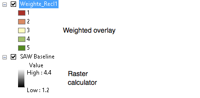
I have various suitability layers (raster) with cells classified into 1, 2, 3, 4, 5 with 5 being the most suitable.
When I combine my layers and I use Spatial analyst Raster Calculator in ArcGIS (10.3), with weighting multiplied as in layer1*0.2 + layer2*0.2 + layer3*0.2 +layer4*0.2 + layer5*0.2, the output is not what I expect: it creates values between 1.2 and 4.4 (floating points values).
However, using the exact same layers and same weight schemes with weighted overlay, it keeps the 1, 2, 3, 4, 5 scheme.
Can anyone explain why this is happening? I've watched tutorials where only 2 classes were used, say 50 and 100 with 100 being most suitable and using raster calculator, it keeps the 50 and 100 range. But why won't mine work?
Much appreciate any feedback
Werner#
Solved! Go to Solution.
Accepted Solutions
- Mark as New
- Bookmark
- Subscribe
- Mute
- Subscribe to RSS Feed
- Permalink
- Report Inappropriate Content
Your weights must total 100% or its relative equivalent (0.25 + 0.75
Weighted overlay... how it works
The return values are integer as shown in the help If you want to scale up your values to preserve some of the fineness of the resultant, then you can do so, but the simple raster calculator approach can also be used, .... just multiply your results by 10 or something, then take the integer value.
So your values aren't necessarily wrong... they are just converted to integer
- Mark as New
- Bookmark
- Subscribe
- Mute
- Subscribe to RSS Feed
- Permalink
- Report Inappropriate Content
Thank you Dan! I appreciate the feedback and recommendation. I will convert them to integer then
- Mark as New
- Bookmark
- Subscribe
- Mute
- Subscribe to RSS Feed
- Permalink
- Report Inappropriate Content
so I've just read (How Weighted Sum works—Help | ArcGIS Desktop)
- The Weighted Sum tool does not rescale the reclassified values back to an evaluation scale.
- The Weighted Sum tool allows floating-point and integer values, whereas the Weighted Overlay tool only accepts integer rasters as inputs.
Would it be incorrect, just to compare the data (apples with apples), to conver tthe weighted sum output data back to integer format using the "INT" tool? In otherwords normalise the data back to the evaluation scale of 1, 2, 3, 4 and 5?
- Mark as New
- Bookmark
- Subscribe
- Mute
- Subscribe to RSS Feed
- Permalink
- Report Inappropriate Content
Dan answered my question... 🙂
- Mark as New
- Bookmark
- Subscribe
- Mute
- Subscribe to RSS Feed
- Permalink
- Report Inappropriate Content
Glad it worked... you can play with the input ranges and scales to get the results you want... just keep changes in scale relative. and the weights apportioned to 100% ( or 0-1)