Turn on suggestions
Auto-suggest helps you quickly narrow down your search results by suggesting possible matches as you type.
Cancel
- Home
- :
- All Communities
- :
- Products
- :
- ArcGIS Spatial Analyst
- :
- ArcGIS Spatial Analyst Questions
- :
- Re: �??Zoom to selected�?� from the attribute tabl...
Options
- Subscribe to RSS Feed
- Mark Topic as New
- Mark Topic as Read
- Float this Topic for Current User
- Bookmark
- Subscribe
- Mute
- Printer Friendly Page
???Zoom to selected??? from the attribute table of the raster
Subscribe
4033
9
07-03-2012 01:26 PM
07-03-2012
01:26 PM
- Mark as New
- Bookmark
- Subscribe
- Mute
- Subscribe to RSS Feed
- Permalink
- Report Inappropriate Content
???Zoom to selected??? from the attribute table of the raster
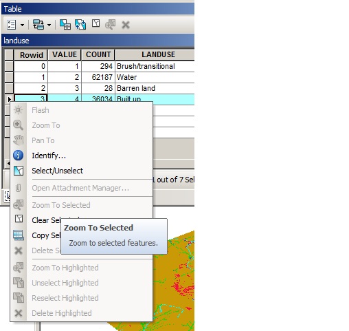
I???m wondering why the command ???Zoom to selected??? is not active in the attribute table of the raster. How could we zoom to the selected cells?
[ATTACH=CONFIG]15743[/ATTACH]
Thank you for the help,
Best
Jamal
I???m wondering why the command ???Zoom to selected??? is not active in the attribute table of the raster. How could we zoom to the selected cells?
[ATTACH=CONFIG]15743[/ATTACH]
Thank you for the help,
Best
Jamal
----------------------------------------
Jamal Numan
Geomolg Geoportal for Spatial Information
Ramallah, West Bank, Palestine
Jamal Numan
Geomolg Geoportal for Spatial Information
Ramallah, West Bank, Palestine
9 Replies
10-08-2012
09:39 AM
- Mark as New
- Bookmark
- Subscribe
- Mute
- Subscribe to RSS Feed
- Permalink
- Report Inappropriate Content
Hi Jamal,
Did you ever got the answer for this? I am just wondering the same. I am doing something that i wanted to find that pixel, but couldn't figure it out.
Risa
Did you ever got the answer for this? I am just wondering the same. I am doing something that i wanted to find that pixel, but couldn't figure it out.
Risa
10-09-2012
10:23 AM
- Mark as New
- Bookmark
- Subscribe
- Mute
- Subscribe to RSS Feed
- Permalink
- Report Inappropriate Content
I think that Zoom to selected works only with feature classes/datasets, not rasters.
If you select a row on the integer raster attribute table*, you can run "Conversion Tools.tbx\From Raster\Raster to Polygon" and it will convert only the selected raster grids to polygons. Then you can choose the new polygon data set and zoom to it. If you were automating this as a tool, I could see doing it this way; otherwise, I'm not sure how you would do it. I see no commands or tools yet.
*You can only get an attribute table from an integer raster.
10-10-2012
03:23 AM
- Mark as New
- Bookmark
- Subscribe
- Mute
- Subscribe to RSS Feed
- Permalink
- Report Inappropriate Content
Dear MBoucher21,
That works but it took awhile to convert just one cell. thank you very much for your suggestions
That works but it took awhile to convert just one cell. thank you very much for your suggestions
10-12-2012
12:49 PM
- Mark as New
- Bookmark
- Subscribe
- Mute
- Subscribe to RSS Feed
- Permalink
- Report Inappropriate Content
Hi Jamal,
Did you ever got the answer for this? I am just wondering the same. I am doing something that i wanted to find that pixel, but couldn't figure it out.
Risa
Hi Risa,
Unfortunately, I didn�??t find any solution for this problem.
Sounds that we need workaround for this issue! As always!
Best
Jamal
----------------------------------------
Jamal Numan
Geomolg Geoportal for Spatial Information
Ramallah, West Bank, Palestine
Jamal Numan
Geomolg Geoportal for Spatial Information
Ramallah, West Bank, Palestine
10-12-2012
03:00 PM
- Mark as New
- Bookmark
- Subscribe
- Mute
- Subscribe to RSS Feed
- Permalink
- Report Inappropriate Content
Hi Jamal,
Zoom To Selected is short for Zoom to Selected Features. Using your screenshot in the original post, what would you have us do if you selected value = 2? There are 25551 pixels. Where do you want us to zoom? The rows in a raster attribute table are not like rows of discrete features in a feature class, nor is there a shape field containing geometry for easy query. It's not like there is a property within a raster dataset that stores the minimum bounding geometry for each value in the raster that could be used as a zoom extent.
The case where the count is 1 is the only time you have a discrete record in a raster attribute table. I would argue its quite uncommon from all the data I've seen over the years. Zooming to selected pixels would have to make sense for all cases to even be considered.
There are multiple ways to 'find' this pixel.
1. As stated earlier, convert to features.
2. Create a new raster with just that one pixel. There are several ways to do this one. Raster calculator, conditional statements, or if you want to make it easy just use Extract by Attribute from spatial analyst.
Best,
Eric
10-12-2012
09:40 PM
- Mark as New
- Bookmark
- Subscribe
- Mute
- Subscribe to RSS Feed
- Permalink
- Report Inappropriate Content
Excellent reply Eric. You have clearly identified the differences between data structures. their pros and cons, that the casual user may choose to overlook.
10-15-2012
01:31 PM
- Mark as New
- Bookmark
- Subscribe
- Mute
- Subscribe to RSS Feed
- Permalink
- Report Inappropriate Content
Hi Jamal,
Zoom To Selected is short for Zoom to Selected Features. Using your screenshot in the original post, what would you have us do if you selected value = 2? There are 25551 pixels. Where do you want us to zoom? The rows in a raster attribute table are not like rows of discrete features in a feature class, nor is there a shape field containing geometry for easy query. It's not like there is a property within a raster dataset that stores the minimum bounding geometry for each value in the raster that could be used as a zoom extent.
The case where the count is 1 is the only time you have a discrete record in a raster attribute table. I would argue its quite uncommon from all the data I've seen over the years. Zooming to selected pixels would have to make sense for all cases to even be considered.
There are multiple ways to 'find' this pixel.
1. As stated earlier, convert to features.
2. Create a new raster with just that one pixel. There are several ways to do this one. Raster calculator, conditional statements, or if you want to make it easy just use Extract by Attribute from spatial analyst.
Best,
Eric
Many thanks for the contribution Erci.
still, I don�??t see any problem to have the �??zoom to�?� working for cells!
It is the same as we do it for vector when we select more than one feature and apply the �??zoom to�?�! zooming to many cells or many features should be the same!
Best
Jamal
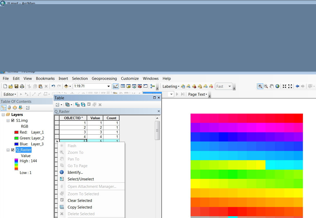
[ATTACH=CONFIG]18446[/ATTACH]
----------------------------------------
Jamal Numan
Geomolg Geoportal for Spatial Information
Ramallah, West Bank, Palestine
Jamal Numan
Geomolg Geoportal for Spatial Information
Ramallah, West Bank, Palestine
10-18-2012
08:49 AM
- Mark as New
- Bookmark
- Subscribe
- Mute
- Subscribe to RSS Feed
- Permalink
- Report Inappropriate Content
Jamal,
Your request will definitely be considered for some future version. It turns out there are some ideas already floating around for zooming to pixels, although not quite like you (from a table selection). Thanks for the feedback.
Best,
Eric
Your request will definitely be considered for some future version. It turns out there are some ideas already floating around for zooming to pixels, although not quite like you (from a table selection). Thanks for the feedback.
Best,
Eric
10-19-2012
09:21 AM
- Mark as New
- Bookmark
- Subscribe
- Mute
- Subscribe to RSS Feed
- Permalink
- Report Inappropriate Content
Jamal,
Your request will definitely be considered for some future version. It turns out there are some ideas already floating around for zooming to pixels, although not quite like you (from a table selection). Thanks for the feedback.
Best,
Eric
Thanks Eric. Yes, please consider it.
Best
Jamal
----------------------------------------
Jamal Numan
Geomolg Geoportal for Spatial Information
Ramallah, West Bank, Palestine
Jamal Numan
Geomolg Geoportal for Spatial Information
Ramallah, West Bank, Palestine