- Home
- :
- All Communities
- :
- Products
- :
- ArcGIS Survey123
- :
- ArcGIS Survey123 Questions
- :
- Why are latitude and longitude values switched on ...
- Subscribe to RSS Feed
- Mark Topic as New
- Mark Topic as Read
- Float this Topic for Current User
- Bookmark
- Subscribe
- Mute
- Printer Friendly Page
Why are latitude and longitude values switched on my photos
- Mark as New
- Bookmark
- Subscribe
- Mute
- Subscribe to RSS Feed
- Permalink
- Report Inappropriate Content
Using the code Latitude: ${Photo_P | getValue:"y"} Longitude: ${Photo_P | getValue:"x"} I added latitude and longitude values on my report for the photos and noticed that the latitude value came back negative for a northern hemisphere photo. I checked the photo properties and noticed the longitude was a positive number; as the photo georeferences correctly, there must be some data referencing that it is a west or negative value. I also noticed that the values were switched when displaying them in Survey123.
Why does my latitude come back negative on the report?
Why are the values switched in Survey123?
Values as they appear on the report
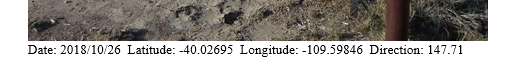
Values as they appear in Survey123 and the photo properties

- Mark as New
- Bookmark
- Subscribe
- Mute
- Subscribe to RSS Feed
- Permalink
- Report Inappropriate Content
This is odd. It appears that the latitude value is flipped on your report. I can't see the direction on the photo properties. Latitude in the northern hemisphere is positive, while longitude in the western hemisphere is negative. To check myself, I searched Google for SLC latitude and got 40.7608° N, 111.8910° W or (40.7608, -111.8910).
The Survey123 website is wrong but in a different way. -109 latitude does not exist and 40 longitudes would put you in Europe. I replicated this issue on one of my own surveys with a photo from Baltimore, MD. Shot on an iPhone. The reported Lat/Long is in Antarctica.

Looks like a bug!
- Mark as New
- Bookmark
- Subscribe
- Mute
- Subscribe to RSS Feed
- Permalink
- Report Inappropriate Content
Hi Nicholas, Elliott
Thank you for the feedback. I can confirm it's a bug and can be fixed in the next update after 3.1 release.
- Mark as New
- Bookmark
- Subscribe
- Mute
- Subscribe to RSS Feed
- Permalink
- Report Inappropriate Content
Zhifang, is there a planned date for the 3.1 update? I thought it was supposed to happen within October?
- Mark as New
- Bookmark
- Subscribe
- Mute
- Subscribe to RSS Feed
- Permalink
- Report Inappropriate Content
Hi Mike,
3.1 release has been available on 11/2 https://community.esri.com/groups/survey123/blog/2018/11/02/st-kilda-penguin-release-31 . Please be noticed that this bug is raised so close to the 3.1 release so we can only fix it in "the next update after 3.1 release", which is a hotfix to 3.1 release and planned no later than early Dec.
- Mark as New
- Bookmark
- Subscribe
- Mute
- Subscribe to RSS Feed
- Permalink
- Report Inappropriate Content
Hi all,
The bug has been fixed with a small update to the website last week, coordinates in the image viewer and feature report should work as expected now.
Thanks again for all your feedbacks!