- Home
- :
- All Communities
- :
- Products
- :
- ArcGIS Survey123
- :
- ArcGIS Survey123 Questions
- :
- Re: Why is it not pulling Altitude and Horizontal ...
- Subscribe to RSS Feed
- Mark Topic as New
- Mark Topic as Read
- Float this Topic for Current User
- Bookmark
- Subscribe
- Mute
- Printer Friendly Page
Why is it not pulling Altitude and Horizontal Accuracy from the geopoint? Why is the latitude and longitude data being cut off in AGOL and not matching what is being collected in Survey123? Why is my UTM Zone incorrect? How do I fix them?
- Mark as New
- Bookmark
- Subscribe
- Mute
- Subscribe to RSS Feed
- Permalink
- Report Inappropriate Content
My survey is set-up to collect the geopoint, see the below table. I'm using a Trimble Catalyst to get a more accurate location within 1 meter. However, when the survey pulls down the data it's incomplete and not totally correct.

Below is how the data looks in the Survey123 App when collecting the location in the field. It shows it's not pulling down altitude and horizontal accuracy data. So did I do something wrong with the calculation field?

This is how the data looks on AGOL in the pop-up. The latitude and longitude data isn't pulling down the completed location. The altitude and horizontal accuracy aren't pulling any data. In addition, the UTM coordinates aren't pulling down the correct zone. It should be 16N not 16S.

Any suggestion on how to fix the pulldata information. Why is it not pulling Altitude and Horizontal Accuracy from the geopoint? Why is the latitude and longitude data being cut off in AGOL and not matching what is being collected in Survey123? Why is my UTM Zone incorrect? Finally, how do I these issues?
- Mark as New
- Bookmark
- Subscribe
- Mute
- Subscribe to RSS Feed
- Permalink
- Report Inappropriate Content
Hi Estelle,
First, to confirm, you are using the Trimble Mobile Manager app as the mock location provider in Android and that you are using a relatively recent (since December) version? Survey123 does not connect directly to the Catalyst; instead, it relies on the system location provider to receive it's location.
With regard to the UTM coordinate, 16S is the correct zone & latitude band (not hemisphere) for the coordinate.
- Mark as New
- Bookmark
- Subscribe
- Mute
- Subscribe to RSS Feed
- Permalink
- Report Inappropriate Content
Yes, I have the Trimble Mobile Manager app on my Samsung tablet. I made sure it was connected before I collected my point in Survey123.
- Mark as New
- Bookmark
- Subscribe
- Mute
- Subscribe to RSS Feed
- Permalink
- Report Inappropriate Content
Estella,
You need to "configure" the "pop-up" window for the layer within the AGOL web map that you have the layer within to show more then 2 decimals.
Click on the feature layer name
Click on the three dots
Choose Configure Pop-up
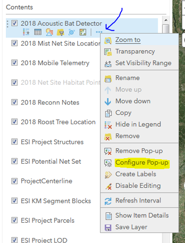
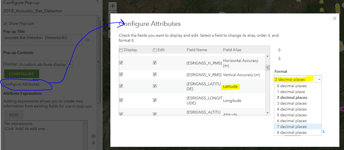
Click on "Configure Attributes"
Then select the field and change the number of decimals being displayed within the pop-up
Cheers!
Mike
- Mark as New
- Bookmark
- Subscribe
- Mute
- Subscribe to RSS Feed
- Permalink
- Report Inappropriate Content
Awesome, Thanks Mike. It works now I can see the whole coordinates.
- Mark as New
- Bookmark
- Subscribe
- Mute
- Subscribe to RSS Feed
- Permalink
- Report Inappropriate Content
You're very welcome. I had a similar question some time ago and I thought I would pass along the solution.
- Mark as New
- Bookmark
- Subscribe
- Mute
- Subscribe to RSS Feed
- Permalink
- Report Inappropriate Content
Hi Estella,
I just did a bit of testing with a Catalyst. Survey123 was able to read the location and accuracy information from the Catalyst. A couple of things I noted as I was testing:
- Make sure that Trimble Mobile Manager has been set as the mock location provider. It looks like there are some issues with Android's UI in setting it as the mock location provider (see Unable to set Trimble mobile manager as Mock lo... | Trimble ), I found it easiest to remove the other applications in the mock location provider list to test
- In addition to setting the mock location provider, there is a separate switch in the Trimble Mobile Manager app to enable sharing of location - ensure that is set to on as well.