Turn on suggestions
Auto-suggest helps you quickly narrow down your search results by suggesting possible matches as you type.
Cancel
- Home
- :
- All Communities
- :
- Products
- :
- ArcGIS Viewer for Flex (Retired)
- :
- ArcGIS Viewer for Flex Questions
- :
- Re: Python script tool works in Desktop but fails ...
Options
- Subscribe to RSS Feed
- Mark Topic as New
- Mark Topic as Read
- Float this Topic for Current User
- Bookmark
- Subscribe
- Mute
- Printer Friendly Page
Python script tool works in Desktop but fails in Web,
Subscribe
04-14-2013
12:29 PM
- Mark as New
- Bookmark
- Subscribe
- Mute
- Subscribe to RSS Feed
- Permalink
- Report Inappropriate Content
Python script tool works in Desktop but fails in Web,
Ian Peebles has generously shared a python script tool that display xy coordinates.
For me it is worked fine on the ArcGIS desktop, and published successfully on the server, but as it is added to the one of the web applications builders like (.Net, Silverlight, Flex), it fails to work
[ATTACH=CONFIG]23481[/ATTACH], [ATTACH=CONFIG]23482[/ATTACH], [ATTACH=CONFIG]23483[/ATTACH]
Where might be my mistake?
The python script tool, instructions and screenshots can be downloaded from the link below
http://www.mediafire.com/?5ay8m6yu777606r
Thank you
Best
Jamal
----------------
Developed by "Ian Peebles"
http://forums.arcgis.com/threads/78352-Displaying-more-than-one-
displaying (x,y) in Desktop and Web application
1. outputworkspace (folder used for scratch)
2. Script (folder that contains the XY.py script)
3. Symbology (folder that contains the output symbology as layer files)
4. Toolbox.tbx (contains the FindCoordinate script tool)
The script contains a creation of an event layer that uses your coordinate system.
Steps to follow:
1. Copy these files into a folder to your local drive or server. You might name it Coordinates.
2. Set the scratch workspace in your .mxd. In this case, I used: C:\Files\GIS\Coordinates\outputworkspace (Geoprocessing -- Environment -- Workspace -- Scratch Workspace)
3. Open the Toolbox and run the tool.
4. Enter in the coordinate and click OK. Takes about 1 second to run.
5. The results will appear in the table of contents, symbolized with the coordinates labeled based on the referenced layer file.
6. If the script successfully runs, in ArcMap go to: Geoprocessing -- Results -- Current Session.
7. Right Click on the last geoprocessing results and choose Share as Geoprocessing Service.
8. Following the publishing of your geoprocessing service, you can add this into your silverlight application as a tool.
------------------------------------------------------------------
----------------------------------------
Jamal Numan
Geomolg Geoportal for Spatial Information
Ramallah, West Bank, Palestine
Jamal Numan
Geomolg Geoportal for Spatial Information
Ramallah, West Bank, Palestine
Solved! Go to Solution.
1 Solution
Accepted Solutions
04-16-2013
06:38 AM
- Mark as New
- Bookmark
- Subscribe
- Mute
- Subscribe to RSS Feed
- Permalink
- Report Inappropriate Content
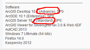
This really isn't a developer-y problem at all:
[ATTACH=CONFIG]23548[/ATTACH]
[ATTACH=CONFIG]23549[/ATTACH]
That tool requires an advanced license, which you have on desktop but not server..
[ATTACH=CONFIG]23548[/ATTACH]
[ATTACH=CONFIG]23549[/ATTACH]
That tool requires an advanced license, which you have on desktop but not server..
5 Replies
04-15-2013
06:39 AM
- Mark as New
- Bookmark
- Subscribe
- Mute
- Subscribe to RSS Feed
- Permalink
- Report Inappropriate Content
Perhaps try to run the tool from the GP service's REST endpoint: if it fails here, examine the GP service. If it succeeds, the problem is in your client app.
You might also want to look at client logs (I believe this is available in the latest Flex release) and ArcGIS Server logs.
You might also want to look at client logs (I believe this is available in the latest Flex release) and ArcGIS Server logs.
by
Anonymous User
Not applicable
04-15-2013
10:32 AM
- Mark as New
- Bookmark
- Subscribe
- Mute
- Subscribe to RSS Feed
- Permalink
- Report Inappropriate Content
Original User: Jamal432@gmail.com
Many thanks Robert for the help,
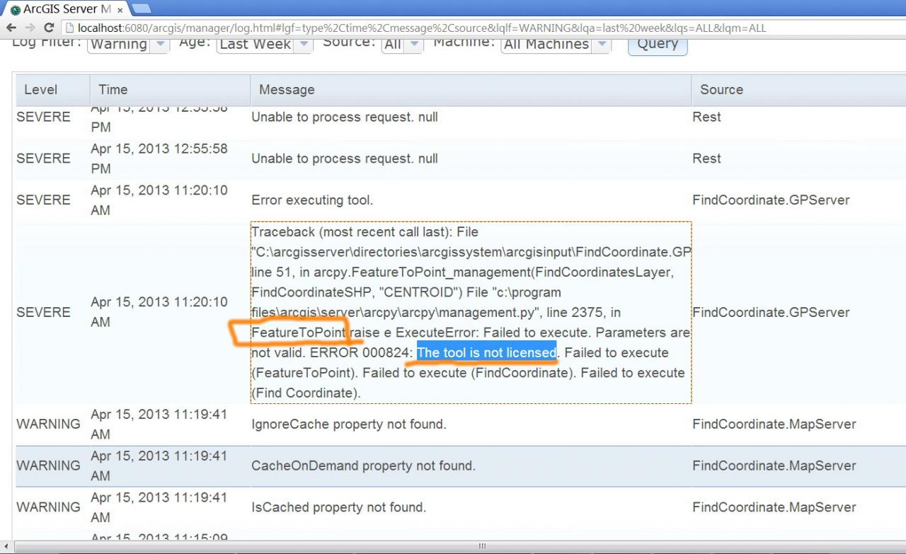
It fails to work from GP service! I got the log details below:
[ATTACH=CONFIG]23515[/ATTACH]
But how does it work on the desktop but not as service?
[ATTACH=CONFIG]23516[/ATTACH], [ATTACH=CONFIG]23518[/ATTACH]
How might this issue be overcome?
I was really struggling since long time ago with this issue and couldn�??t find any solution.
Unfortunately, I�??m not a developer to play with the code of the tool
Suggestions are highly appreciated
Best
Jamal
Perhaps try to run the tool from the GP service's REST endpoint: if it fails here, examine the GP service. If it succeeds, the problem is in your client app.
You might also want to look at client logs (I believe this is available in the latest Flex release) and ArcGIS Server logs.
Many thanks Robert for the help,
It fails to work from GP service! I got the log details below:
[ATTACH=CONFIG]23515[/ATTACH]
But how does it work on the desktop but not as service?
[ATTACH=CONFIG]23516[/ATTACH], [ATTACH=CONFIG]23518[/ATTACH]
How might this issue be overcome?
I was really struggling since long time ago with this issue and couldn�??t find any solution.
Unfortunately, I�??m not a developer to play with the code of the tool
Suggestions are highly appreciated
Best
Jamal
04-16-2013
06:38 AM
- Mark as New
- Bookmark
- Subscribe
- Mute
- Subscribe to RSS Feed
- Permalink
- Report Inappropriate Content
by
Anonymous User
Not applicable
04-17-2013
11:29 AM
- Mark as New
- Bookmark
- Subscribe
- Mute
- Subscribe to RSS Feed
- Permalink
- Report Inappropriate Content
Original User: Jamal432@gmail.com
Thank you Robert for the answer,
Correct, in the python script, the �??feature to point�?� tool requires advanced license level
[ATTACH=CONFIG]23577[/ATTACH], [ATTACH=CONFIG]23578[/ATTACH]
Best
Jamal
This really isn't a developer-y problem at all:
[ATTACH=CONFIG]23548[/ATTACH]
[ATTACH=CONFIG]23549[/ATTACH]
That tool requires an advanced license, which you have on desktop but not server..
Thank you Robert for the answer,
Correct, in the python script, the �??feature to point�?� tool requires advanced license level
[ATTACH=CONFIG]23577[/ATTACH], [ATTACH=CONFIG]23578[/ATTACH]
Best
Jamal
05-04-2013
06:00 AM
- Mark as New
- Bookmark
- Subscribe
- Mute
- Subscribe to RSS Feed
- Permalink
- Report Inappropriate Content
This really isn't a developer-y problem at all:
[ATTACH=CONFIG]23548[/ATTACH]
[ATTACH=CONFIG]23549[/ATTACH]
That tool requires an advanced license, which you have on desktop but not server..
Hi Robert,
I managed to get an evaluation copy for the ArcGIS Server Advanced and the tool worked like a charm
http://forums.arcgis.com/threads/78352-Displaying-more-than-one-%28x-y%29-point?p=295355#post295355
Many thanks
Best
Jamal
----------------------------------------
Jamal Numan
Geomolg Geoportal for Spatial Information
Ramallah, West Bank, Palestine
Jamal Numan
Geomolg Geoportal for Spatial Information
Ramallah, West Bank, Palestine