Turn on suggestions
Auto-suggest helps you quickly narrow down your search results by suggesting possible matches as you type.
Cancel
- Home
- :
- All Communities
- :
- Products
- :
- ArcGIS Viewer for Flex (Retired)
- :
- ArcGIS Viewer for Flex Questions
- :
- Re: Table of Contents - Legend Widget for FlexView...
Options
- Subscribe to RSS Feed
- Mark Topic as New
- Mark Topic as Read
- Float this Topic for Current User
- Bookmark
- Subscribe
- Mute
- Printer Friendly Page
Table of Contents - Legend Widget for FlexViewer 2.x
Subscribe
98905
664
12-01-2010 07:30 AM
12-01-2010
07:30 AM
- Mark as New
- Bookmark
- Subscribe
- Mute
- Subscribe to RSS Feed
- Permalink
- Report Inappropriate Content
All,
Here is the next in my line of widgets for the FlexViewer 2.x.
The legend portion of this widget is the same code as my dynamic legend widget so,
IT IS FOR ARCGIS SERVER 10 OR GREATER ONLY
This is just a simple TOC Widget that includes my dynamic legend component.
This widget also includes my enhancement for map service transparency,
right click context menu for zoom to make layer visible, and my scale
dependent renderer for the TOC checkboxes.
664 Replies
05-10-2012
07:49 AM
- Mark as New
- Bookmark
- Subscribe
- Mute
- Subscribe to RSS Feed
- Permalink
- Report Inappropriate Content
Robert, I don't suppose there is anything we can do to fix this leak shown in the Debug Mode in Flash Builder?
Any direction you could lead me to look into it or is it no big deal?
Any direction you could lead me to look into it or is it no big deal?
[SWF] \bin-debug\widgets\TOC\TOCWidget.swf - 511,883 bytes after decompression
warning: The class widgets.TOC.toc.tocClasses.LegendDataClassItem has been used in a call to net.registerClassAlias() in _TOCWidget_FlexInit. This will cause widgets.TOC:TOCWidget to be leaked. To resolve the leak, define widgets.TOC.toc.tocClasses.LegendDataClassItem in the top-level application.
warning: The class widgets.TOC.toc.tocClasses.LegendDataItem has been used in a call to net.registerClassAlias() in _TOCWidget_FlexInit. This will cause widgets.TOC:TOCWidget to be leaked. To resolve the leak, define widgets.TOC.toc.tocClasses.LegendDataItem in the top-level application.
warning: The class widgets.TOC.toc.tocClasses.LegendSymbolItem has been used in a call to net.registerClassAlias() in _TOCWidget_FlexInit. This will cause widgets.TOC:TOCWidget to be leaked. To resolve the leak, define widgets.TOC.toc.tocClasses.LegendSymbolItem in the top-level application.
05-10-2012
08:28 AM
- Mark as New
- Bookmark
- Subscribe
- Mute
- Subscribe to RSS Feed
- Permalink
- Report Inappropriate Content
Lefteris,
Straight from the readme.txt
THank you and I apologize for wasting your time. I should have read it more thoroughly.
05-10-2012
10:50 PM
- Mark as New
- Bookmark
- Subscribe
- Mute
- Subscribe to RSS Feed
- Permalink
- Report Inappropriate Content
Hey Robert,
thanks for the new Version and the Major Change. Great Stuff.
thanks for the new Version and the Major Change. Great Stuff.
05-11-2012
04:05 AM
- Mark as New
- Bookmark
- Subscribe
- Mute
- Subscribe to RSS Feed
- Permalink
- Report Inappropriate Content
M Lowry,
I will look into it.
I will look into it.
05-13-2012
01:46 PM
- Mark as New
- Bookmark
- Subscribe
- Mute
- Subscribe to RSS Feed
- Permalink
- Report Inappropriate Content
Hello,
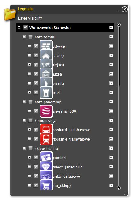
My name is Adrian and I'm student from Poland. I have download your widget and it is great! However, I have little problem with largeness of symbols. In enclosed file you can see what I mean. Images are too large and text titles are covered. Can I modify this widget to repair this and how can I do it? Could you help me?
Thanks,
Adrian
My project: http://www.warszawskastarowka.pl/mapa/
05-13-2012
06:54 PM
- Mark as New
- Bookmark
- Subscribe
- Mute
- Subscribe to RSS Feed
- Permalink
- Report Inappropriate Content
Adrian,
Wow I can't believe you are the first to report this issue. The fix is 2 simple lines of code and I will add them to the next release. If you happen to be using the uncompiled version than you can add the fix your self by opening the TocMapLayerItem.as and find the loadImage function and add the two lines below in red:
Also you may want to st your maps top attribute back to 40 unless you have some reason for the 100 empty pixels above your map.
Don't forget to click the top arrow (promote).
as shown in the below graphic:

Wow I can't believe you are the first to report this issue. The fix is 2 simple lines of code and I will add them to the next release. If you happen to be using the uncompiled version than you can add the fix your self by opening the TocMapLayerItem.as and find the loadImage function and add the two lines below in red:
        private function loadImage(imageData:String):Image
        {
            const base64Dec:Base64Decoder = new Base64Decoder();
            base64Dec.decode(imageData);
            const byteArr:ByteArray = base64Dec.toByteArray();

            const loader:Loader = new Loader();
            const lc:LoaderContext = new LoaderContext(false);
            const image:Image = new Image();
            image.maxHeight = 30;
            image.maxWidth = 30;
            loader.contentLoaderInfo.addEventListener(Event.COMPLETE,
                function(e:Event):void
                {
                    image.smoothBitmapContent = true;
                    image.source = e.currentTarget.content;
                });
            loader.loadBytes(byteArr, lc);
            return image;
        }
Also you may want to st your maps top attribute back to 40 unless you have some reason for the 100 empty pixels above your map.
Don't forget to click the top arrow (promote).
as shown in the below graphic:
05-14-2012
07:09 AM
- Mark as New
- Bookmark
- Subscribe
- Mute
- Subscribe to RSS Feed
- Permalink
- Report Inappropriate Content
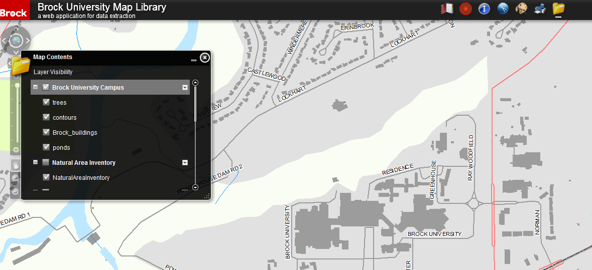
RS,
I am having trouble with the TOC. I have it in the config file and I turned off the layervisibility in the map switcher. When the viewer loads and I open the Map Contents 1) nothing shows up, 2) the symbols are unknown to the legend, 3) I can no longer zoom in or out (only pan).
Some of the layers do not have defined min/max (could that be the issue?). Even layers that do have defined min and max (such as my mosaic dataset), does not show up.
Thoughts?
Here is a screen grab for reference.
Greg
[ATTACH=CONFIG]14303[/ATTACH]
05-14-2012
07:29 AM
- Mark as New
- Bookmark
- Subscribe
- Mute
- Subscribe to RSS Feed
- Permalink
- Report Inappropriate Content
Greg,
A couple of questions...
A couple of questions...
- Are you using Flex Viewer 2.5?
- Is your ArcGIS Server at least version 10?
05-14-2012
07:32 AM
- Mark as New
- Bookmark
- Subscribe
- Mute
- Subscribe to RSS Feed
- Permalink
- Report Inappropriate Content
Yes on both fronts. I went through the read-me file and made sure to follow the instructions. I will note that the same issue occurs with the "Legend" widget from ESRI.
Greg,
A couple of questions...Hopefully you saw these requirement in the documentation of the download.
- Are you using Flex Viewer 2.5?
- Is your ArcGIS Server at least version 10?
05-14-2012
07:36 AM
- Mark as New
- Bookmark
- Subscribe
- Mute
- Subscribe to RSS Feed
- Permalink
- Report Inappropriate Content
Greg,
Hmm... that actually helps a lot. it points to the possibility that you have changed something in the standard setup of your ArcGIS Server. Did you happen to disable anonymous access to your ArcGIS output folders or change some setting in IIS to require authentication?
Hmm... that actually helps a lot. it points to the possibility that you have changed something in the standard setup of your ArcGIS Server. Did you happen to disable anonymous access to your ArcGIS output folders or change some setting in IIS to require authentication?