Turn on suggestions
Auto-suggest helps you quickly narrow down your search results by suggesting possible matches as you type.
Cancel
- Home
- :
- All Communities
- :
- Products
- :
- Viewer for Silverlight (Retired)
- :
- Viewer for Silverlight
- :
- Not all features are drawing in Viewer
Options
- Subscribe to RSS Feed
- Mark Topic as New
- Mark Topic as Read
- Float this Topic for Current User
- Bookmark
- Subscribe
- Mute
- Printer Friendly Page
04-24-2012
01:37 PM
- Mark as New
- Bookmark
- Subscribe
- Mute
- Subscribe to RSS Feed
- Permalink
- Report Inappropriate Content
Just trying my first viewer app and already got an issue. I have published a MXD with feature layers and I can view the parcel layer correctly in ArcMAp and ArcExplorer.
When I add the parcel layer as an individual layer in the viewer only some of the parcels are drawn. When I add the map service that contain the parcel layer it is drawn correctly. Is there a limitation as to the number of features in an individual layer?
I have attached some pictures of the area in question showing the individual layer SL viewer view, the MXD view, and the SL viewer map service view.
Notes:
SLviewer 1.0.1
ArcGIS 10 sp1
Window 7 dev machine
Solved! Go to Solution.
1 Solution
Accepted Solutions
05-02-2012
11:13 AM
- Mark as New
- Bookmark
- Subscribe
- Mute
- Subscribe to RSS Feed
- Permalink
- Report Inappropriate Content
Hi Angel,
It looks like it's a bug. As you noted, it happens in both the SL Viewer and ArcGIS.com, which means that it's on the server side of things. At this point you'll need to continue using the workaround you've mentioned.
Thanks for you patience on this!
Katy
It looks like it's a bug. As you noted, it happens in both the SL Viewer and ArcGIS.com, which means that it's on the server side of things. At this point you'll need to continue using the workaround you've mentioned.
Thanks for you patience on this!
Katy
Katy Dalton | Technical Consultant
THE SCIENCE OF WHERE™
THE SCIENCE OF WHERE™
10 Replies
by
Anonymous User
Not applicable
04-24-2012
05:22 PM
- Mark as New
- Bookmark
- Subscribe
- Mute
- Subscribe to RSS Feed
- Permalink
- Report Inappropriate Content
Hi Angel,
Can you ensure that the OBJECTID and Shape fields are turned on for the layer in the mxd ?
In addition, are there any group layer or scale-dependency layers in the map document ? Can you please try to turn everything on in the map document and restart your map service?
Can you ensure that the OBJECTID and Shape fields are turned on for the layer in the mxd ?
In addition, are there any group layer or scale-dependency layers in the map document ? Can you please try to turn everything on in the map document and restart your map service?
by
Anonymous User
Not applicable
04-25-2012
11:52 AM
- Mark as New
- Bookmark
- Subscribe
- Mute
- Subscribe to RSS Feed
- Permalink
- Report Inappropriate Content
Original User: angelg
Hi Pho,
I checked the layers on the mxd and the OBJECTID and shape fields are all turn on. I did have scale-dependent layers and removed the scales. I then save the mxd and restarted the map service. I had no group layers in my mxd. It looks like only the parcels that have shading are coming across in SLV. I have attached new photos. I also tryed dropping the layer in SLV and re-add. I also refreshed the service. Still not working.
Any ideas?
Thanks
04-26-2012
01:22 PM
- Mark as New
- Bookmark
- Subscribe
- Mute
- Subscribe to RSS Feed
- Permalink
- Report Inappropriate Content
All Map Service layers limit the number of features that are returned. I believe it is set to 1000. This is probably the problem.
Craig
Craig
by
Anonymous User
Not applicable
04-26-2012
01:52 PM
- Mark as New
- Bookmark
- Subscribe
- Mute
- Subscribe to RSS Feed
- Permalink
- Report Inappropriate Content
Original User: angelg
I thought about the limit also. The one thing I tried was zooming in until only a few parcels were showing. Only those parcels that were shaded appeared. Those without shading did not appear. I also increase the number of records returned by the server from 1000 to 5000 and restared the map service. Still have the same issue. I also cleared the cache on the server. Still the same issue.
ESRI any help?
04-27-2012
10:03 AM
- Mark as New
- Bookmark
- Subscribe
- Mute
- Subscribe to RSS Feed
- Permalink
- Report Inappropriate Content
Hi Angel,
Are the parcels shaded or are they actually "selected" in the map document? I just wonder if it is related to parcels/features being in a "selected" state when published. Also, the reason the full map service works is that it is bringing over image tiles, so you see everything. But when you add the feature service/individual layers, it's retrieving graphics.
Katy
Katy Dalton | Technical Consultant
THE SCIENCE OF WHERE™
THE SCIENCE OF WHERE™
by
Anonymous User
Not applicable
04-30-2012
07:49 AM
- Mark as New
- Bookmark
- Subscribe
- Mute
- Subscribe to RSS Feed
- Permalink
- Report Inappropriate Content
Original User: angelg
Hi Katy,
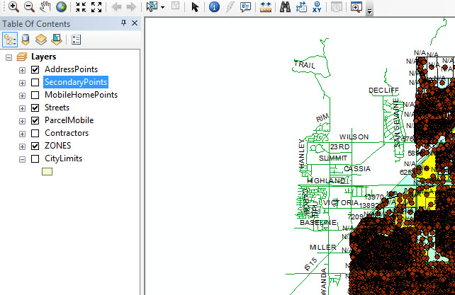
The parcels are shaded depending an an attribute value.(see pic) We do this on a nightly basis. This mxd also has a moblie map service associated with it since it is used with our mobile app. Question for you. If a feature service is set to retrieve 1000 records and I zoom in to where only 200 parcels are showing, should not all 200 parcels show up whether shaded or not?
Thanks.
Hi Katy,
The parcels are shaded depending an an attribute value.(see pic) We do this on a nightly basis. This mxd also has a moblie map service associated with it since it is used with our mobile app. Question for you. If a feature service is set to retrieve 1000 records and I zoom in to where only 200 parcels are showing, should not all 200 parcels show up whether shaded or not?
Thanks.
04-30-2012
10:55 AM
- Mark as New
- Bookmark
- Subscribe
- Mute
- Subscribe to RSS Feed
- Permalink
- Report Inappropriate Content
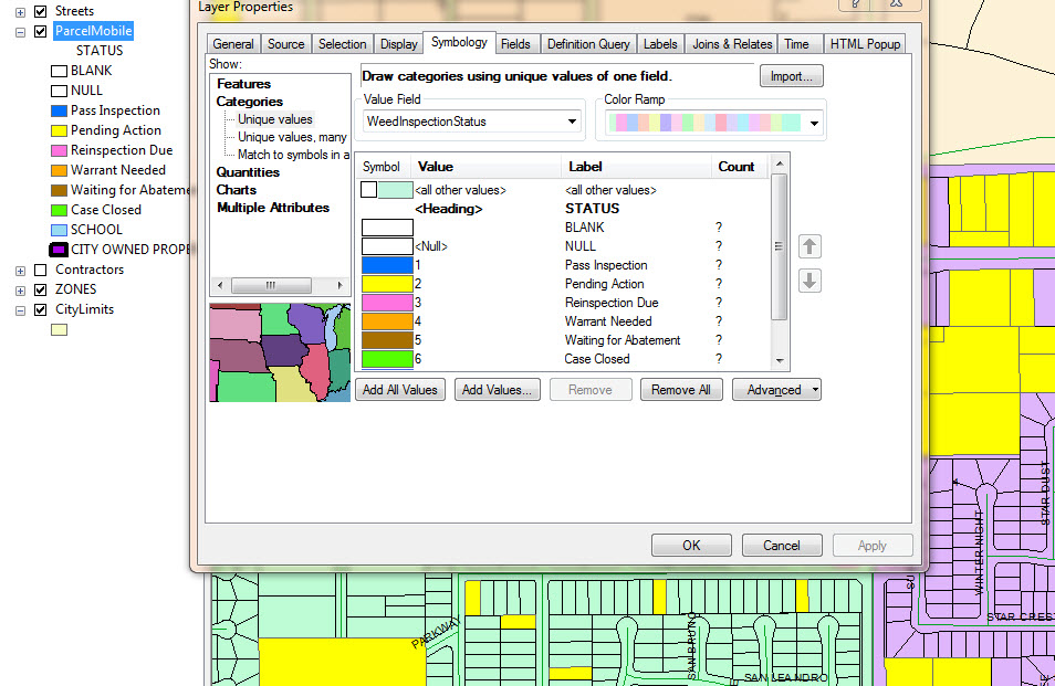
After playing around with the settings I finally discovered the problem. The shading of the parcels depends on the attribute of a field, which is defined on the symbology tab within the Layer Property setting. The field which is used to define the symbology/shading of the layer can have a value of "NULL"(see symbology1.jpg). The SL viewer(SLV) cannot handle the "Null" value within symbology. It does not draw them. Once I removed the value of "NULL" from the list and enabled the "<all other values>"(symbol is defined as Hollow -see symbology2.jpg) the parcels are seen in the SLV(see SLViewer3.jpg).
Bug??
Note to ESRI: The same above issue occurrs when viewing a feature layer on ArcGIS.com with the value of a symbology field set to null. When applying the above changes you can see the parcels on ArcGIS.com
Can you confirm both?
Thanks
Bug??
Note to ESRI: The same above issue occurrs when viewing a feature layer on ArcGIS.com with the value of a symbology field set to null. When applying the above changes you can see the parcels on ArcGIS.com
Can you confirm both?
Thanks
by
Anonymous User
Not applicable
05-01-2012
08:10 AM
- Mark as New
- Bookmark
- Subscribe
- Mute
- Subscribe to RSS Feed
- Permalink
- Report Inappropriate Content
Original User: katydalton
Hi Angel,
Quite possibly a bug; we're looking in to it now.
As for your other question: "If a feature service is set to retrieve 1000 records and I zoom in to where only 200 parcels are showing, should not all 200 parcels show up whether shaded or not?" --- Yes, all 200 parcels should display.
Katy
Hi Angel,
Quite possibly a bug; we're looking in to it now.
As for your other question: "If a feature service is set to retrieve 1000 records and I zoom in to where only 200 parcels are showing, should not all 200 parcels show up whether shaded or not?" --- Yes, all 200 parcels should display.
Katy
05-02-2012
11:13 AM
- Mark as New
- Bookmark
- Subscribe
- Mute
- Subscribe to RSS Feed
- Permalink
- Report Inappropriate Content
Hi Angel,
It looks like it's a bug. As you noted, it happens in both the SL Viewer and ArcGIS.com, which means that it's on the server side of things. At this point you'll need to continue using the workaround you've mentioned.
Thanks for you patience on this!
Katy
It looks like it's a bug. As you noted, it happens in both the SL Viewer and ArcGIS.com, which means that it's on the server side of things. At this point you'll need to continue using the workaround you've mentioned.
Thanks for you patience on this!
Katy
Katy Dalton | Technical Consultant
THE SCIENCE OF WHERE™
THE SCIENCE OF WHERE™