- Home
- :
- All Communities
- :
- User Groups
- :
- Cartography and Maps
- :
- Questions
- :
- Extra Line Appearing on Export
- Subscribe to RSS Feed
- Mark Topic as New
- Mark Topic as Read
- Float this Topic for Current User
- Bookmark
- Subscribe
- Mute
- Printer Friendly Page
Extra Line Appearing on Export
- Mark as New
- Bookmark
- Subscribe
- Mute
- Subscribe to RSS Feed
- Permalink
- Report Inappropriate Content
Hi,
I am using ArcMap 10.5.1.
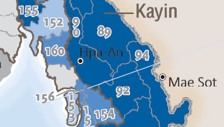
I am making a series of maps though not using DD Pages. On one of my maps, when I export a thin blue line, whose color matches my ocean background, appears running horizontal at an angle across my map. It is quite unsightly and I need to submit my final draft to my client by next week.
I saw an earlier thread suggesting to adjust printer properties and another suggesting to remove rotation on symbols. I have tried all of these options to no avail.
I also tried exporting to various formats, including JPEG and PDF, with same result.
I would be grateful if somebody out there can let me know how to remedy this situation. See screenshot.
Thanks,
Lyndy
- Mark as New
- Bookmark
- Subscribe
- Mute
- Subscribe to RSS Feed
- Permalink
- Report Inappropriate Content
What is the source of the data input? If vector, did you try a repair geometry to ensure you aren't getting bleed-through in the geometry
- Mark as New
- Bookmark
- Subscribe
- Mute
- Subscribe to RSS Feed
- Permalink
- Report Inappropriate Content
Are you using leader lines for the labels/annotation where this problem occurs?
- Mark as New
- Bookmark
- Subscribe
- Mute
- Subscribe to RSS Feed
- Permalink
- Report Inappropriate Content
Yes. I am. But many of my other maps do as well and I am not getting this line.
Any thoughts?
Lyndy
- Mark as New
- Bookmark
- Subscribe
- Mute
- Subscribe to RSS Feed
- Permalink
- Report Inappropriate Content
All of my maps in the series use same underlying data so if it were a geometry issue wouldn't it show up on all maps? In addition, I don't see the line until I export. If it was a geometry issue, wouldn't it be visible in the map?
Lyndy
- Mark as New
- Bookmark
- Subscribe
- Mute
- Subscribe to RSS Feed
- Permalink
- Report Inappropriate Content
Not necessarily. A check wouldn't hurt
The only other thing you can do is sequentially remove layers to isolate the issue, then try that layer in a new, separate project and repeat your procedure. Could be the project, a layer, just about anything
- Mark as New
- Bookmark
- Subscribe
- Mute
- Subscribe to RSS Feed
- Permalink
- Report Inappropriate Content
Hi Dan,
Per your suggestion, I removed all the layers and determined with reasonable certainty the issue is not with any of my layers but rather appears to be something with the data frame. Thus, I examined the data frame properties and determined if I uncheck the Default Group Name in Annotation tab in the the Data Frame Properties (See attached), I don't get the line.
However, the catch is that if I turn this off, all of my leader lines disappear. So it has got to be something related to the annotation and/or data frame properties. I compared the settings with my other maps and they are all the same though so I don't understand why one map is doing this but the others are not.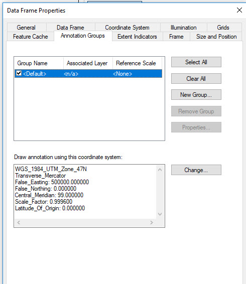
Anyway, I appreciate your help. If anyone else has an idea about what is going on here, please chime in.
Thanks,
Lyndy
- Mark as New
- Bookmark
- Subscribe
- Mute
- Subscribe to RSS Feed
- Permalink
- Report Inappropriate Content
Hi, Lyndy,
I have seen strange behavior like this before. . .we have found that opening a fresh ArcMap and copying the data frame over is simple enough to try. I know it will not answer your question as to what is going on. Also, we have seen lines show up (or disappear) once in while upon printing. Our fix is when printing a PDF, under the advanced tab, check "print as image".
If you have Adobe Pro, simply select the line and delete.
We have seen strange lines and when one (accidentally or not) did some labeling in design view.
Sorry this this reply is low so tech!