- Home
- :
- All Communities
- :
- User Groups
- :
- Coordinate Reference Systems
- :
- Questions
- :
- Re: ESRI imagery world 2D not projecting on the fl...
- Subscribe to RSS Feed
- Mark Topic as New
- Mark Topic as Read
- Float this Topic for Current User
- Bookmark
- Subscribe
- Mute
- Printer Friendly Page
ESRI imagery world 2D not projecting on the fly
- Mark as New
- Bookmark
- Subscribe
- Mute
- Subscribe to RSS Feed
- Permalink
- Report Inappropriate Content
I have traced the outline of an area in Google Earth. Having saved the KMZ I've converted it to a shapefile and then reprojected the shapefile to Arc 1950 UTM 35s (using transformation 8). My data frame is in Arc 1950 UTM 35s. In the dataframe properties I have set a transformation to WGS84 (using transformation 8).
When I add the basemap "World Imagery" (which comes in Web Mercator Auxillary Sphere projection) everything is fine. See below:
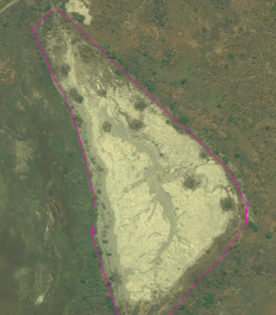
However, if I choose the "ESRI Imagery World 2D" basemap (which comes in WGS84 projection) the shapefile and the basemap no longer line up. See below:

Why is this?
**Update**
As a further test I have started a new MXD. I've brought in the ESRI 2D basemap which has set the dataframe CRS to EPSG 4326 (WGS84).
I've then created a new shapefile in WGS84 and traced around the same feature:
I've converted this new shapefile to a KMZ and this is what it looks like in Google Earth:

Again the offset is ~70m.
- Mark as New
- Bookmark
- Subscribe
- Mute
- Subscribe to RSS Feed
- Permalink
- Report Inappropriate Content
Well, there you go. Someone messed up. Transformation 7 is for DRC.
But I am curious, I am just looking at both in a new ArcMap session, so the frame is still WebMerc (WGS84 based). There is an offset.
I think that the 2d layer is just badly referenced.
- Mark as New
- Bookmark
- Subscribe
- Mute
- Subscribe to RSS Feed
- Permalink
- Report Inappropriate Content
If you are still interested in this question, I recommend downloading the list of Geographic Transformations linked to Esri Knowledge article 000004829, which includes the published accuracy of all the transformations we support. The accuracy of each transformation has been calculated by the agency or company that published the transformation, and Esri does not verify these values. However we do include them in the list for your convenience. As an example, the transformation Arc_1950_To_WGS_1984_7 has a published accuracy of 25 meters, and was calculated by the US Defense Mapping Agency. Generally their transformations are calculated from a single point, so the accuracy is not very precise. In the EPSG Registry, WKID 1119 is listed as being deprecated.
How To: Select the correct geographic (datum) transformation when projecting between datums
Another issue as well - back in 2016 when this question was posted, Google Maps were displaying data in Mercator on a sphere. There are no geographic (datum) transformations between any sphere and a datum. Recently, Google Earth has switched to Mercator on a datum, so transformations can be applied in Esri software to give better alignment.
- « Previous
-
- 1
- 2
- Next »
- « Previous
-
- 1
- 2
- Next »