- Home
- :
- All Communities
- :
- User Groups
- :
- Coordinate Reference Systems
- :
- Questions
- :
- Re: Formula For State Plane to Lat/Lon Conversion
- Subscribe to RSS Feed
- Mark Topic as New
- Mark Topic as Read
- Float this Topic for Current User
- Bookmark
- Subscribe
- Mute
- Printer Friendly Page
Formula For State Plane to Lat/Lon Conversion
- Mark as New
- Bookmark
- Subscribe
- Mute
- Subscribe to RSS Feed
- Permalink
- Report Inappropriate Content
Does anyone know where I can find the equation to put into Excel that will convert CT State Plane coordinates to Lat/Lon? I know ways to programmatically do this using ArcGIS but have a scenario/workflow where we may need to do this from within Excel. Thanks!
- Mark as New
- Bookmark
- Subscribe
- Mute
- Subscribe to RSS Feed
- Permalink
- Report Inappropriate Content
I would very much like a copy of your SQL formulas. I once tried to do this using SQL, but due to the large numbers of formulas involved,and the number of steps, I found that rounding errors became significant, and my results were not as accurate as I needed.
If you have found a better way, I would be very interested.
- Mark as New
- Bookmark
- Subscribe
- Mute
- Subscribe to RSS Feed
- Permalink
- Report Inappropriate Content
Since I can't attach through a comment, below are the Sql functions, and some notes to be aware of...
- These functions calculate longitude and latitude for Lambert Conformal Conic 2-parallel projections (as this is what our production features are stored in (wkid: 6463 --- NAD 1983 (2011) Iowa State Plane North))
- Note lines 59 through 76 --- you will need to provide the values for your coordinate system
- You can find these values within the XY Coordinate System properties of a feature class
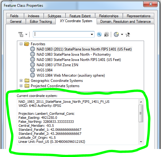
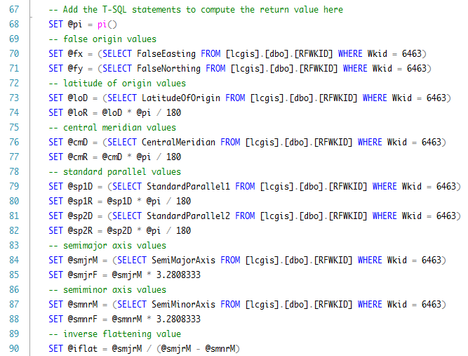
- I do this by storing the values in a table and call them through a SELECT statement, that way the values are stored in one place (example below)
- You can find these values within the XY Coordinate System properties of a feature class
Longitude Calculation
USE [**DatabaseName**]
GO
/****** Object: UserDefinedFunction [dbo].[get_longitude] ******/
SET ANSI_NULLS ON
GO
SET QUOTED_IDENTIFIER ON
GO
-- =============================================
-- Author: Your Name
-- Create date: Date
-- Description: Returns longitude given x,y coordinates in Lambert Conformal Conic projection
-- =============================================
CREATE FUNCTION [dbo].[get_longitude]
(
-- Add the parameters for the function here
@x numeric(24,12), --state plane x coordinate
@y numeric(24,12) --state plane y coordinate
)
RETURNS numeric(24,12)
AS
BEGIN
-- Declare the return variable here
DECLARE
@pi numeric(24,12), --pi
@fx numeric(24,12), --false easting
@fy numeric(24,12), --false northing
@cmD numeric(24,12), --central meridian in degrees
@cmR numeric(24,12), --central meridian in radians
@sp1D numeric(24,12), --standard parallel 1 in degrees
@sp1R numeric(24,12), --standard parallel 1 in radians
@sp2D numeric(24,12), --standard parallel 2 in degrees
@sp2R numeric(24,12), --standard parallel 2 in radians
@loD numeric(24,12), --latitude of origin in degrees
@loR numeric(24,12), --latitude of origin in radians
@smjrM numeric(24,12), --semimajor axis in meters
@smjrF numeric(24,12), --semimajor axis in feet
@smnrM numeric(24,12), --semiminor axis in meters
@smnrF numeric(24,12), --semiminor axis in feet
@flat numeric(24,12), --flattenging
@iflat numeric(24,12), --inverse flattening
@e numeric(24,12), --eccentricity
@m1 numeric(24,12), --calculation value
@m2 numeric(24,12), --calculation value
@t1 numeric(24,12), --calculation value
@t2 numeric(24,12), --calculation value
@tf numeric(24,12), --calculation value
@n numeric(24,12), --calculation value
@F numeric(24,12), --calculation value
@rf numeric(24,12), --calculation value
@rz numeric(24,12), --calculation value
@tz numeric(24,12), --calculation value
@zz numeric(24,12), --calculation value
@lonR numeric(24,12), --longitude in radians
@lonD numeric(24,12) --longitude in degrees
-- Add the T-SQL statements to compute the return value here
SET @pi = pi()
-- false origin values
SET @fx = /* Enter false easting value */
SET @fy = /* Enter false northing value */
-- latitude of origin values
SET @loD = /* Enter latitude of origin value */
SET @loR = @loD * @pi / 180
-- central meridian values
SET @cmD = /* Enter central meridian value */
SET @cmR = @cmD * @pi / 180
-- standard parallel values
SET @sp1D = /* Enter standard parallel 1 value */
SET @sp1R = @sp1D * @pi / 180
SET @sp2D = /* Enter standard parallel 2 value */
SET @sp2R = @sp2D * @pi / 180
-- semimajor axis values
SET @smjrM = /* Enter semimajor axis value in meters */
SET @smjrF = @smjrM * 3.2808333
-- semiminor axis values
SET @smnrM = /* Enter semiminor axis value in meters */
SET @smnrF = @smnrM * 3.2808333
-- inverse flattening value
SET @iflat = @smjrM / (@smjrM - @smnrM)
-- flattenging value
SET @flat = 1 / @iflat
-- eccentricity value
SET @e = SQRT(2 * @flat - SQUARE(@flat))
-- m values
SET @m1 = COS(@sp1R) / POWER((1 - SQUARE(@e) * SQUARE(SIN(@sp1R))), 0.5)
SET @m2 = COS(@sp2R) / POWER((1 - SQUARE(@e) * SQUARE(SIN(@sp2R))), 0.5)
-- t values
SET @t1 = TAN((@pi / 4) - (@sp1R / 2)) / POWER((1 - (@e * SIN(@sp1R))) / (1 + (@e * SIN(@sp1R))), (@e / 2))
SET @t2 = TAN((@pi / 4) - (@sp2R / 2)) / POWER((1 - (@e * SIN(@sp2R))) / (1 + (@e * SIN(@sp2R))), (@e / 2))
SET @tf = TAN((@pi / 4) - (@loR / 2)) / POWER((1 - (@e * SIN(@loR))) / (1 + (@e * SIN(@loR))), (@e / 2))
-- n value
SET @n = (LOG(@m1) - LOG(@m2)) / (LOG(@t1) - LOG(@t2))
-- f value
SET @F = @m1 / (@n * POWER(@t1, @n))
-- r value
SET @rf = @smjrF * @F * POWER(@tf, @n)
-- r' value
SET @rz = POWER(POWER((@x - @fx), 2) + POWER((@rf - (@y - @fy)), 2), 0.5)
-- t' value
SET @tz = POWER((@rz / (@smjrF * @F)), (1 / @n))
-- thetha' value
SET @zz = ATAN((@x - @fx) / (@rf - (@y - @fy)))
-- longitude value in radians
SET @lonR = ((@zz / @n) + @cmR)
-- longitude value in degrees
SET @lonD = (@lonR * 180) / @pi
-- Return the result of the function
RETURN @lonD;
END
Latitude Calculation
USE [**DatabaseName**]
GO
/****** Object: UserDefinedFunction [dbo].[get_latitude] ******/
SET ANSI_NULLS ON
GO
SET QUOTED_IDENTIFIER ON
GO
-- =============================================
-- Author: Your Name
-- Create date: Date
-- Description: Returns latitude given x,y coordinates in Lambert Conformal Conic projection
-- =============================================
CREATE FUNCTION [dbo].[get_latitude]
(
-- Add the parameters for the function here
@x numeric(24,12), --state plane x coordinate
@y numeric(24,12) --state plane y coordinate
)
RETURNS numeric(24,12)
AS
BEGIN
-- Declare the return variable here
DECLARE
@pi numeric(24,12), --pi
@fx numeric(24,12), --false easting
@fy numeric(24,12), --false northing
@cmD numeric(24,12), --central meridian in degrees
@cmR numeric(24,12), --central meridian in radians
@sp1D numeric(24,12), --standard parallel 1 in degrees
@sp1R numeric(24,12), --standard parallel 1 in radians
@sp2D numeric(24,12), --standard parallel 2 in degrees
@sp2R numeric(24,12), --standard parallel 2 in radians
@loD numeric(24,12), --latitude of origin in degrees
@loR numeric(24,12), --latitude of origin in radians
@smjrM numeric(24,12), --semimajor axis in meters
@smjrF numeric(24,12), --semimajor axis in feet
@smnrM numeric(24,12), --semiminor axis in meters
@smnrF numeric(24,12), --semiminor axis in feet
@flat numeric(24,12), --flattenging
@iflat numeric(24,12), --inverse flattening
@e numeric(24,12), --eccentricity
@m1 numeric(24,12), --calculation value
@m2 numeric(24,12), --calculation value
@t1 numeric(24,12), --calculation value
@t2 numeric(24,12), --calculation value
@tf numeric(24,12), --calculation value
@n numeric(24,12), --calculation value
@F numeric(24,12), --calculation value
@rf numeric(24,12), --calculation value
@rz numeric(24,12), --calculation value
@tz numeric(24,12), --calculation value
@zz numeric(24,12), --calculation value
@latTR numeric(24,12), --latitude trial in radians
@lat1R numeric(24,12), --latitude iteration 1 in radians
@lat2R numeric(24,12), --latitude iteration 2 in radians
@lat3R numeric(24,12), --latitude iteration 3 in radians
@lat4R numeric(24,12), --latitude iteration 4 in radians
@latFR numeric(24,12), --latitude final iteration in radians
@latTD numeric(24,12), --latitude trial in degrees
@lat1D numeric(24,12), --latitude iteration 1 in degrees
@lat2D numeric(24,12), --latitude iteration 2 in degrees
@lat3D numeric(24,12), --latitude iteration 3 in degrees
@lat4D numeric(24,12), --latitude iteration 4 in degrees
@latFD numeric(24,12) --latitude final iteration in degrees
-- Add the T-SQL statements to compute the return value here
SET @pi = pi()
-- false origin values
SET @fx = /* Enter false easting value */
SET @fy = /* Enter false northing value */
-- latitude of origin values
SET @loD = /* Enter latitude of origin value */
SET @loR = @loD * @pi / 180
-- central meridian values
SET @cmD = /* Enter central meridian value */
SET @cmR = @cmD * @pi / 180
-- standard parallel values
SET @sp1D = /* Enter standard parallel 1 value */
SET @sp1R = @sp1D * @pi / 180
SET @sp2D = /* Enter standard parallel 2 value */
SET @sp2R = @sp2D * @pi / 180
-- semimajor axis values
SET @smjrM = /* Enter semimajor axis value in meters */
SET @smjrF = @smjrM * 3.2808333
-- semiminor axis values
SET @smnrM = /* Enter semiminor axis value in meters */
SET @smnrF = @smnrM * 3.2808333
-- inverse flattening value
SET @iflat = @smjrM / (@smjrM - @smnrM)
-- flattenging value
SET @flat = 1 / @iflat
-- eccentricity value
SET @e = SQRT(2 * @flat - SQUARE(@flat))
-- m values
SET @m1 = COS(@sp1R) / POWER((1 - SQUARE(@e) * SQUARE(SIN(@sp1R))), 0.5)
SET @m2 = COS(@sp2R) / POWER((1 - SQUARE(@e) * SQUARE(SIN(@sp2R))), 0.5)
-- t values
SET @t1 = TAN((@pi / 4) - (@sp1R / 2)) / POWER((1 - (@e * SIN(@sp1R))) / (1 + (@e * SIN(@sp1R))), (@e / 2))
SET @t2 = TAN((@pi / 4) - (@sp2R / 2)) / POWER((1 - (@e * SIN(@sp2R))) / (1 + (@e * SIN(@sp2R))), (@e / 2))
SET @tf = TAN((@pi / 4) - (@loR / 2)) / POWER((1 - (@e * SIN(@loR))) / (1 + (@e * SIN(@loR))), (@e / 2))
-- n value
SET @n = (LOG(@m1) - LOG(@m2)) / (LOG(@t1) - LOG(@t2))
-- f value
SET @F = @m1 / (@n * POWER(@t1, @n))
-- r value
SET @rf = @smjrF * @F * POWER(@tf, @n)
-- r' value
SET @rz = POWER(POWER((@x - @fx), 2) + POWER((@rf - (@y - @fy)), 2), 0.5)
-- t' value
SET @tz = POWER((@rz / (@smjrF * @F)), (1 / @n))
-- thetha' value
SET @zz = ATAN((@x - @fx) / (@rf - (@y - @fy)))
-- latitude trial value in radians
SET @latTR = (@pi / 2) - (2 * ATAN(@tz))
-- latitude iteration 1 value in radians
SET @lat1R = (@pi / 2) - (2 * ATAN((@tz * POWER((1 - (@e * SIN(@latTR))) / (1 + (@e * SIN(@latTR))), (@e / 2)))))
-- latitude iteration 2 value in radians
SET @lat2R = (@pi / 2) - (2 * ATAN((@tz * POWER((1 - (@e * SIN(@lat1R))) / (1 + (@e * SIN(@lat1R))), (@e / 2)))))
-- latitude iteration 3 value in radians
SET @lat3R = (@pi / 2) - (2 * ATAN((@tz * POWER((1 - (@e * SIN(@lat2R))) / (1 + (@e * SIN(@lat2R))), (@e / 2)))))
-- latitude iteration 4 value in radians
SET @lat4R = (@pi / 2) - (2 * ATAN((@tz * POWER((1 - (@e * SIN(@lat3R))) / (1 + (@e * SIN(@lat3R))), (@e / 2)))))
-- latitude final iteration value in radians
SET @latFR = (@pi / 2) - (2 * ATAN((@tz * POWER((1 - (@e * SIN(@lat4R))) / (1 + (@e * SIN(@lat4R))), (@e / 2)))))
-- latitude trial value in degrees
SET @latTD = (@latTR * 180) / @pi
-- latitude iteration 1 value in degrees
SET @lat1D = (@lat1R * 180) / @pi
-- latitude iteration 2 value in degrees
SET @lat2D = (@lat2R * 180) / @pi
-- latitude iteration 3 value in degrees
SET @lat3D = (@lat3R * 180) / @pi
-- latitude iteration 4 value in degrees
SET @lat4D = (@lat4R * 180) / @pi
-- latitude final iteration value in degrees
SET @latFD = (@latFR * 180) / @pi
-- Return the latitude in degrees
RETURN @latFD;
END
- Mark as New
- Bookmark
- Subscribe
- Mute
- Subscribe to RSS Feed
- Permalink
- Report Inappropriate Content
I'll give it a try. Thanks!
- Mark as New
- Bookmark
- Subscribe
- Mute
- Subscribe to RSS Feed
- Permalink
- Report Inappropriate Content
This is awesome - thanks so much.Works well, and very fast.
- Mark as New
- Bookmark
- Subscribe
- Mute
- Subscribe to RSS Feed
- Permalink
- Report Inappropriate Content
Very helpful, thanks a million. I have to keep all my geographically projected feature classes in SQL Server for easy retrieval with other applications, and the ESRI Python script I thought I had to use just for reprojection kept crashing and burning on me.
- Mark as New
- Bookmark
- Subscribe
- Mute
- Subscribe to RSS Feed
- Permalink
- Report Inappropriate Content
It looks like the last forum migration messed up the formatting of your code. I've reformatted it to maybe help others. Hope you don't mind.
USE yourDB
GO

/****** Object:  UserDefinedFunction [dbo].[get_longitude] ******/
SET ANSI_NULLS ON
GO
SET QUOTED_IDENTIFIER ON
GO
-- =============================================
-- Author:     Your Name
-- Create date: Date
-- Description:     Returns longitude given x,y coordinates in Lambert Conformal Conic projection
-- =============================================C
CREATE FUNCTION [dbo].[get_longitude] (
        -- Add the parameters for the function here
        @x numeric(24,12),
        --state plane x coordinate
        @y numeric(24,12)
        --state plane y coordinate
    )
    RETURNS numeric(24,12)
    AS
    BEGIN
        -- Declare the return variable here
        DECLARE   @pi numeric(24,12),
        --pi
        @fx numeric(24,12),
        --false easting
        @fy numeric(24,12),
        --false northing
        @cmD numeric(24,12),
        --central meridian in degrees
        @cmR numeric(24,12),
        --central meridian in radians
        @sp1D numeric(24,12),
        --standard parallel 1 in degrees
        @sp1R numeric(24,12),
        --standard parallel 1 in radians
        @sp2D numeric(24,12),
        --standard parallel 2 in degrees
        @sp2R numeric(24,12),
        --standard parallel 2 in radians
        @loD numeric(24,12),
        --latitude of origin in degrees
        @loR numeric(24,12),
        --latitude of origin in radians
        @smjrM numeric(24,12),
        --semimajor axis in meters
        @smjrF numeric(24,12),
        --semimajor axis in feet
        @smnrM numeric(24,12),
        --semiminor axis in meters
        @smnrF numeric(24,12),
        --semiminor axis in feet
        @flat numeric(24,12),
        --flattenging
        @iflat numeric(24,12),
        --inverse flattening
        @e numeric(24,12),
        --eccentricity
        @m1 numeric(24,12),
        --calculation value
        @m2 numeric(24,12),
        --calculation value
        @t1 numeric(24,12),
        --calculation value
        @t2 numeric(24,12),
        --calculation value
        @TF numeric(24,12),
        --calculation value
        @n numeric(24,12),
        --calculation value
        @F numeric(24,12),
        --calculation value
        @RF numeric(24,12),
        --calculation value
        @RZ numeric(24,12),
        --calculation value
        @tz numeric(24,12),
        --calculation value
        @zz numeric(24,12),
        --calculation value
        @lonR numeric(24,12),
        --longitude in radians
        @lonD numeric(24,12)
        --longitude in degrees
        -- Add the T-SQL statements to compute the return value here
        SET @pi = pi()
        -- false origin values
        SET @fx = /* Enter false easting value */
        SET @fy = /* Enter false northing value */
        -- latitude of origin values
        SET @loD = /* Enter latitude of origin value */
        SET @loR = @loD * @pi / 180
        -- central meridian values
        SET @cmD = /* Enter central meridian value */
        SET @cmR = @cmD * @pi / 180
        -- standard parallel values
        SET @sp1D = /* Enter standard parallel 1 value */
        SET @sp1R = @sp1D * @pi / 180
        SET @sp2D = /* Enter standard parallel 2 value */
        SET @sp2R = @sp2D * @pi / 180
        -- semimajor axis values
        SET @smjrM =  /* Enter semimajor axis value in meters */
        SET @smjrF = @smjrM * 3.2808333
        -- semiminor axis values
        SET @smnrM =  /* Enter semiminor axis value in meters */
        SET @smnrF = @smnrM * 3.2808333
        -- inverse flattening value
        SET @iflat = @smjrM / (@smjrM - @smnrM)
        -- flattenging value
        SET @flat = 1 / @iflat
        -- eccentricity value
        SET @e = SQRT(2 * @flat - SQUARE(@flat))
        -- m values
        SET @m1 = COS(@sp1R) / POWER((1 - SQUARE(@e) * SQUARE(SIN(@sp1R))), 0.5)
        SET @m2 = COS(@sp2R) / POWER((1 - SQUARE(@e) * SQUARE(SIN(@sp2R))), 0.5)
        -- t values
        SET @t1 = TAN((@pi / 4) - (@sp1R / 2)) / POWER((1 - (@e * SIN(@sp1R))) / (1 + (@e * SIN(@sp1R))), (@e / 2))
        SET @t2 = TAN((@pi / 4) - (@sp2R / 2)) / POWER((1 - (@e * SIN(@sp2R))) / (1 + (@e * SIN(@sp2R))), (@e / 2))
        SET @TF = TAN((@pi / 4) - (@loR / 2)) / POWER((1 - (@e * SIN(@loR))) / (1 + (@e * SIN(@loR))), (@e / 2))
        -- n value
        SET @n = (LOG(@m1) - LOG(@m2)) / (LOG(@t1) - LOG(@t2))
        -- f value
        SET @F = @m1 / (@n * POWER(@t1, @n))
        -- r value
        SET @RF = @smjrF * @F * POWER(@tf, @n)
        -- r' value
        SET @RZ = POWER(POWER((@x - @fx), 2) + POWER((@rf - (@y - @fy)), 2), 0.5)
        -- t' value
        SET @tz = POWER((@rz / (@smjrF * @F)), (1 / @n))
        -- thetha' value
        SET @zz = ATAN((@x - @fx) / (@rf - (@y - @fy)))
        -- longitude value in radians
        SET @lonR = ((@zz / @n) + @cmR)
        -- longitude value in degrees
        SET @lonD = (@lonR * 180) / @pi
        -- Return the result of the function
        RETURN @lonD;
    END
USE yourDB
GO

/****** Object:  UserDefinedFunction [dbo].[get_latitude] ******/
SET ANSI_NULLS ON
GO
SET QUOTED_IDENTIFIER ON
GO

CREATE FUNCTION [dbo].[get_latitude] (

        -- Add the parameters for the function here
        @x numeric(24,12),
        --state plane x coordinate
        @y numeric(24,12)
        --state plane y coordinate
    )
    RETURNS numeric(24,12)
        AS
    BEGIN
-- Declare the return variable here
        DECLARE @pi numeric(24,12),
        --pi
        @fx numeric(24,12),
        --false easting
        @fy numeric(24,12),
        --false northing
        @cmD numeric(24,12),
        --central meridian in degrees
        @cmR numeric(24,12),
        --central meridian in radians
        @sp1D numeric(24,12),
        --standard parallel 1 in degrees
        @sp1R numeric(24,12),
        --standard parallel 1 in radians
        @sp2D numeric(24,12),
        --standard parallel 2 in degrees
        @sp2R numeric(24,12),
        --standard parallel 2 in radians
        @loD numeric(24,12),
        --latitude of origin in degrees
        @loR numeric(24,12),
        --latitude of origin in radians
        @smjrM numeric(24,12),
        --semimajor axis in meters
        @smjrF numeric(24,12),
        --semimajor axis in feet
        @smnrM numeric(24,12),
        --semiminor axis in meters
        @smnrF numeric(24,12),
        --semiminor axis in feet
        @flat numeric(24,12),
        --flattenging
        @iflat numeric(24,12),
        --inverse flattening
        @e numeric(24,12),
        --eccentricity
        @m1 numeric(24,12),
        --calculation value
        @m2 numeric(24,12),
        --calculation value
        @t1 numeric(24,12),
        --calculation value
        @t2 numeric(24,12),
        --calculation value
        @TF numeric(24,12),
        --calculation value
        @n numeric(24,12),
        --calculation value
        @F numeric(24,12),
        --calculation value
        @RF numeric(24,12),
        --calculation value
        @RZ numeric(24,12),
        --calculation value
        @tz numeric(24,12),
        --calculation value
        @zz numeric(24,12),
        --calculation value
        @latTR numeric(24,12),
        --latitude trial in radians
        @lat1R numeric(24,12),
        --latitude iteration 1 in radians
        @lat2R numeric(24,12),
        --latitude iteration 2 in radians
        @lat3R numeric(24,12),
        --latitude iteration 3 in radians
        @lat4R numeric(24,12),
        --latitude iteration 4 in radians
        @latFR numeric(24,12),
        --latitude final iteration in radians
        @latTD numeric(24,12),
        --latitude trial in degrees
        @lat1D numeric(24,12),
        --latitude iteration 1 in degrees
        @lat2D numeric(24,12),
        --latitude iteration 2 in degrees
        @lat3D numeric(24,12),
        --latitude iteration 3 in degrees
        @lat4D numeric(24,12),
        --latitude iteration 4 in degrees
        @latFD numeric(24,12)
        --latitude final iteration in degrees
        -- Add the T-SQL statements to compute the return value here
        SET @pi = pi()
        -- false origin values
        SET @fx =  /* Enter false easting value */
        SET @fy =  /* Enter false northing value */
        -- latitude of origin values
        SET @loD =  /* Enter latitude of origin value */
        SET @loR = @loD * @pi / 180
        -- central meridian values
        SET @cmD =  /* Enter central meridian value */
        SET @cmR = @cmD * @pi / 180
        -- standard parallel values
        SET @sp1D =  /* Enter standard parallel 1 value */
        SET @sp1R = @sp1D * @pi / 180
        SET @sp2D =  /* Enter standard parallel 2 value */
        SET @sp2R = @sp2D * @pi / 180
        -- semimajor axis values
        SET @smjrM =   /* Enter semimajor axis value in meters */
        SET @smjrF = @smjrM * 3.2808333
        -- semiminor axis values
        SET @smnrM =  /* Enter semiminor axis value in meters */
        SET @smnrF = @smnrM * 3.2808333
        -- inverse flattening value
        SET @iflat = @smjrM / (@smjrM - @smnrM)
        -- flattenging value
        SET @flat = 1 / @iflat
        -- eccentricity value
        SET @e = SQRT(2 * @flat - SQUARE(@flat))
        -- m values
        SET @m1 = COS(@sp1R) / POWER((1 - SQUARE(@e) * SQUARE(SIN(@sp1R))), 0.5)
        SET @m2 = COS(@sp2R) / POWER((1 - SQUARE(@e) * SQUARE(SIN(@sp2R))), 0.5)
        -- t values
        SET @t1 = TAN((@pi / 4) - (@sp1R / 2)) / POWER((1 - (@e * SIN(@sp1R))) / (1 + (@e * SIN(@sp1R))), (@e / 2))
        SET @t2 = TAN((@pi / 4) - (@sp2R / 2)) / POWER((1 - (@e * SIN(@sp2R))) / (1 + (@e * SIN(@sp2R))), (@e / 2))
        SET @TF = TAN((@pi / 4) - (@loR / 2)) / POWER((1 - (@e * SIN(@loR))) / (1 + (@e * SIN(@loR))), (@e / 2))
        -- n value
        SET @n = (LOG(@m1) - LOG(@m2)) / (LOG(@t1) - LOG(@t2))
        -- f value
        SET @F = @m1 / (@n * POWER(@t1, @n))
        -- r value
        SET @RF = @smjrF * @F * POWER(@tf, @n)
        -- r\' value
        SET @RZ = POWER(POWER((@x - @fx), 2) + POWER((@rf - (@y - @fy)), 2), 0.5)
        -- t\' value
        SET @tz = POWER((@rz / (@smjrF * @F)), (1 / @n))
        -- thetha\'' value
        SET @zz = ATAN((@x - @fx) / (@rf - (@y - @fy)))
        -- latitude trial value in radians
        SET @latTR = (@pi / 2) - (2 * ATAN(@tz))
        -- latitude iteration 1 value in radians
        SET @lat1R = (@pi / 2) - (2 * ATAN((@tz * POWER((1 - (@e * SIN(@latTR))) / (1 + (@e * SIN(@latTR))), (@e / 2)))))
        -- latitude iteration 2 value in radians
        SET @lat2R = (@pi / 2) - (2 * ATAN((@tz * POWER((1 - (@e * SIN(@lat1R))) / (1 + (@e * SIN(@lat1R))), (@e / 2)))))
        -- latitude iteration 3 value in radians
        SET @lat3R = (@pi / 2) - (2 * ATAN((@tz * POWER((1 - (@e * SIN(@lat2R))) / (1 + (@e * SIN(@lat2R))), (@e / 2)))))
        -- latitude iteration 4 value in radians
        SET @lat4R = (@pi / 2) - (2 * ATAN((@tz * POWER((1 - (@e * SIN(@lat3R))) / (1 + (@e * SIN(@lat3R))), (@e / 2)))))
        -- latitude final iteration value in radians
        SET @latFR = (@pi / 2) - (2 * ATAN((@tz * POWER((1 - (@e * SIN(@lat4R))) / (1 + (@e * SIN(@lat4R))), (@e / 2)))))
        -- latitude trial value in degrees
        SET @latTD = (@latTR * 180) / @pi
        -- latitude iteration 1 value in degrees
        SET @lat1D = (@lat1R * 180) / @pi
        -- latitude iteration 2 value in degrees
        SET @lat2D = (@lat2R * 180) / @pi
        -- latitude iteration 3 value in degrees
        SET @lat3D = (@lat3R * 180) / @pi
        -- latitude iteration 4 value in degrees
        SET @lat4D = (@lat4R * 180) / @pi
        -- latitude final iteration value in degrees
        SET @latFD = (@latFR * 180) / @pi
        -- Return the latitude in degrees
        RETURN @latFD;
    END
- Mark as New
- Bookmark
- Subscribe
- Mute
- Subscribe to RSS Feed
- Permalink
- Report Inappropriate Content
This is awesome. Thank you
- Mark as New
- Bookmark
- Subscribe
- Mute
- Subscribe to RSS Feed
- Permalink
- Report Inappropriate Content
It might be worth noting that the above code uses 39.37 / 12 = 3.2808333 for the meters to feet conversions. This is correct for the US Survey Foot, which (since 1959) is slightly different from an international foot. The difference would amount to about 1 foot per 100 miles. I presume the Survey Foot is correct for this application.
- Mark as New
- Bookmark
- Subscribe
- Mute
- Subscribe to RSS Feed
- Permalink
- Report Inappropriate Content
Hi @mpboyle ,
If you could provide those calculations (if you still have access to them), it would be much appreciated!
- Mark as New
- Bookmark
- Subscribe
- Mute
- Subscribe to RSS Feed
- Permalink
- Report Inappropriate Content
Fairly certain it was this publication I used for the formulas.