- Home
- :
- All Communities
- :
- User Groups
- :
- Coordinate Reference Systems
- :
- Questions
- :
- Why did 'Project' tool erase features & attributes...
- Subscribe to RSS Feed
- Mark Topic as New
- Mark Topic as Read
- Float this Topic for Current User
- Bookmark
- Subscribe
- Mute
- Printer Friendly Page
Why did 'Project' tool erase features & attributes?
- Mark as New
- Bookmark
- Subscribe
- Mute
- Subscribe to RSS Feed
- Permalink
- Report Inappropriate Content
I got some shapefiles from a local energy utility company. They are in GCS_WGS_1984. I brought them into ArcMap (10.3) and performed a Project to get them into my projection (NAD_1983_SPC CO-N). This erased all the features. Never had this happen before. The original shapefile is intact, but the newly created file geodatabase feature class has zero features. Zero features, zero attributes. It brought over the fields & field names, but there's not a shred of data. I've tried doing it in ArcMap, ArcCatalog, shapefile --> shapefile, and shapefile --> file geodatabase feature class. What am I missing?
Thanks in advance, Alex
- Mark as New
- Bookmark
- Subscribe
- Mute
- Subscribe to RSS Feed
- Permalink
- Report Inappropriate Content
load the file, examine its properties and provide the extents for the file. When doing the project, the file must have a defined coordinate system for it to work so I assume that is the case. and you had no features selected when you did this.
- Mark as New
- Bookmark
- Subscribe
- Mute
- Subscribe to RSS Feed
- Permalink
- Report Inappropriate Content
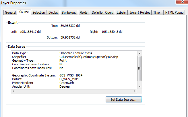
See extents below for the source file. Did the project with features selected and unselected both just for fun.
- Mark as New
- Bookmark
- Subscribe
- Mute
- Subscribe to RSS Feed
- Permalink
- Report Inappropriate Content
Did you do everything outside of a geodatabase. The area is quite small. It would be worthwhile seeing if it displays in a new project, projecting it to another shapefile then proceed from there. since it is a point file, the repair geometry won't do anything.
- Mark as New
- Bookmark
- Subscribe
- Mute
- Subscribe to RSS Feed
- Permalink
- Report Inappropriate Content
Does the same thing happen if you try to project to another CRS, like UTM? I've never seen that particular CRS and it doesn't appear in my list, so I assume it's custom.
- Mark as New
- Bookmark
- Subscribe
- Mute
- Subscribe to RSS Feed
- Permalink
- Report Inappropriate Content
Same thing projecting into UTM.
- Mark as New
- Bookmark
- Subscribe
- Mute
- Subscribe to RSS Feed
- Permalink
- Report Inappropriate Content
I am not familiar with NAD_1983_SPC CO-N, athough it looks like a custom state plane north system for Colorado... If that's true, can you verify the coordinate system? What happens if you reproject another shapefile? What happens if you use a built-in state plane projection?
- Mark as New
- Bookmark
- Subscribe
- Mute
- Subscribe to RSS Feed
- Permalink
- Report Inappropriate Content
The full name for the coordinate system we use is NAD_1983_StatePlane_Colorado_North_FIPS_0501_Feet. All of our data is in this projection. For grins I ran the Project tool and used HARN 1983 and NAD_1983_StatePlane_Colorado_Central_FIPS_0502 as well. Same results - field names persist in the new feature class, but no features or attribute data.
- Mark as New
- Bookmark
- Subscribe
- Mute
- Subscribe to RSS Feed
- Permalink
- Report Inappropriate Content
I can project other shapefiles fine. So it must be something to do with the source files from the utility company then?
Happy to share one of these shapefiles for testing purposes.
- Mark as New
- Bookmark
- Subscribe
- Mute
- Subscribe to RSS Feed
- Permalink
- Report Inappropriate Content
Yes, please zip and upload.