Turn on suggestions
Auto-suggest helps you quickly narrow down your search results by suggesting possible matches as you type.
Cancel
- Home
- :
- All Communities
- :
- Products
- :
- Data Management
- :
- Data Management Questions
- :
- Inverted terrain features
Options
- Subscribe to RSS Feed
- Mark Topic as New
- Mark Topic as Read
- Float this Topic for Current User
- Bookmark
- Subscribe
- Mute
- Printer Friendly Page
Inverted terrain features
Subscribe
371
2
06-12-2013 05:00 AM
by
Anonymous User
Not applicable
06-12-2013
05:00 AM
- Mark as New
- Bookmark
- Subscribe
- Mute
- Subscribe to RSS Feed
- Permalink
- Report Inappropriate Content
Original User: jimcousins
Greetings,
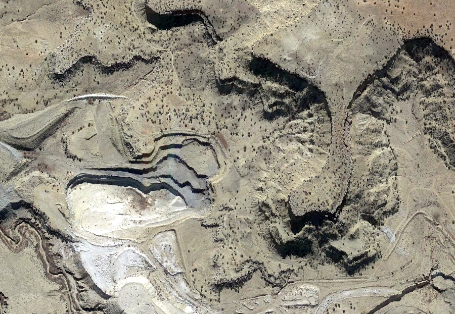
I have some aerial imagery with the shadowing causing terrain features to be inverted - hills look like depressions and gullies look like ridges (see attachment Aerial unchanged.jpg). Is there any way to alter this so it looks correct without rotating the data frame (what is should look like is attachment Aerial rotated.jpg).
Greetings,
I have some aerial imagery with the shadowing causing terrain features to be inverted - hills look like depressions and gullies look like ridges (see attachment Aerial unchanged.jpg). Is there any way to alter this so it looks correct without rotating the data frame (what is should look like is attachment Aerial rotated.jpg).
2 Replies
by
Anonymous User
Not applicable
06-12-2013
12:43 PM
- Mark as New
- Bookmark
- Subscribe
- Mute
- Subscribe to RSS Feed
- Permalink
- Report Inappropriate Content
Original User: sarajase
Appears to be scanning error/artifact.
Perhaps nothing much could be done about it other than to rescan
By some chance it is not a product of some digital mapping camera (such as MS Vexcel or Leica ADS80), isn't it?
Thanks
Appears to be scanning error/artifact.
Perhaps nothing much could be done about it other than to rescan
By some chance it is not a product of some digital mapping camera (such as MS Vexcel or Leica ADS80), isn't it?
Thanks
06-12-2013
01:26 PM
- Mark as New
- Bookmark
- Subscribe
- Mute
- Subscribe to RSS Feed
- Permalink
- Report Inappropriate Content
You misunderstand. This is not an artifact from scanning, it is an optical illusion created by the direction of the shadows on the ground during the image capture from the airplane. the two photos show the same extents and the same groundsurface, but the features that are raised appear sunken and the features that are sunken appear raised. When you rotate the photo 180 degrees, the features invert and what was sunken appears raised and what was raised appears sunken.
My question is what method exists (if any) that will produce the inversion of features without rotating the image.
Regards,
Jim
My question is what method exists (if any) that will produce the inversion of features without rotating the image.
Regards,
Jim