- Home
- :
- All Communities
- :
- User Groups
- :
- Elevation Data
- :
- Questions
- :
- Re: Units when adding surface elevation to polylin...
- Subscribe to RSS Feed
- Mark Topic as New
- Mark Topic as Read
- Float this Topic for Current User
- Bookmark
- Subscribe
- Mute
- Printer Friendly Page
Re: Units when adding surface elevation to polylines
- Mark as New
- Bookmark
- Subscribe
- Mute
- Subscribe to RSS Feed
- Permalink
- Report Inappropriate Content
I needed slope information for some polyline sections, and after adding surface information to the file and calculating total slope, I find that the result does not seem to match what was previously measures at one of the sites (my test section).
Now, I know the z values are in meters. They come from the National Map Project DEM file I used for the surface data. I would assume the "Shape_Le_1" is as well ... but that doesn't make sense when I convert to feet and take the slope. Where would ArcMap source those units from?
The overall data frame units for the layer are decimal degrees ... but the length can't be in decimal degrees because the values would be tiny.
I tried changing the data frame units to "feet" but still have the same values when I add surface data.
How can I be sure where these units are sourced from and what they are?
(I am a novice user so this is probably a ridiculous question but I have to be 100% about the units)
Solved! Go to Solution.
Accepted Solutions
- Mark as New
- Bookmark
- Subscribe
- Mute
- Subscribe to RSS Feed
- Permalink
- Report Inappropriate Content
Hi Cathina, to find the linear units of any layer, right click on it, select properties, and then select the source tab. Linear unit is different from angular unit, such as degrees. How exactly are you doing the conversion to feet? It's probably a good ide to get your DEM and polylines into the same projection before you run the analysis, by using either the Project or Project Raster tool. Be aware though, that you may never get a perfect match between the ground measurement, and your calculated one , due to the resolution and accuracy of your DEM.
- Mark as New
- Bookmark
- Subscribe
- Mute
- Subscribe to RSS Feed
- Permalink
- Report Inappropriate Content
Well, it looks as though the polylines are in meters, but the "linear units" section for the DEM is empty (which makes sense as it is elevation/z data).
In this regime, would the "shape length" be in meters (from the polyline) and the z values be in meters (from the DEM)?
They are both from the NAD 1983 datum / source
- Mark as New
- Bookmark
- Subscribe
- Mute
- Subscribe to RSS Feed
- Permalink
- Report Inappropriate Content
(also, my simple conversion from meters to feet is ~ X m * (0.03048 ft/1m) )
- Mark as New
- Bookmark
- Subscribe
- Mute
- Subscribe to RSS Feed
- Permalink
- Report Inappropriate Content
Hmmm, if it has a spatial reference it should still have a linear unit, regardless of what the data represents, because it still has x and y values. See this screenshot for a DEM I have:

What does your DEM say for spatial reference?
- Mark as New
- Bookmark
- Subscribe
- Mute
- Subscribe to RSS Feed
- Permalink
- Report Inappropriate Content
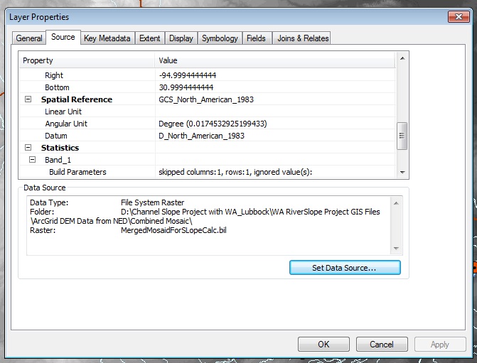
Oh, that is strange. It says GCS_North_American_1983
Here is a screenshot ... I hate that this is such a mystery even at this stage. I have a whole new question about the calculated slope to post, but I'm not going there until I get this unit thing worked out. 
- Mark as New
- Bookmark
- Subscribe
- Mute
- Subscribe to RSS Feed
- Permalink
- Report Inappropriate Content
Ok, what does your original polyline layer say when you do the same?
- Mark as New
- Bookmark
- Subscribe
- Mute
- Subscribe to RSS Feed
- Permalink
- Report Inappropriate Content
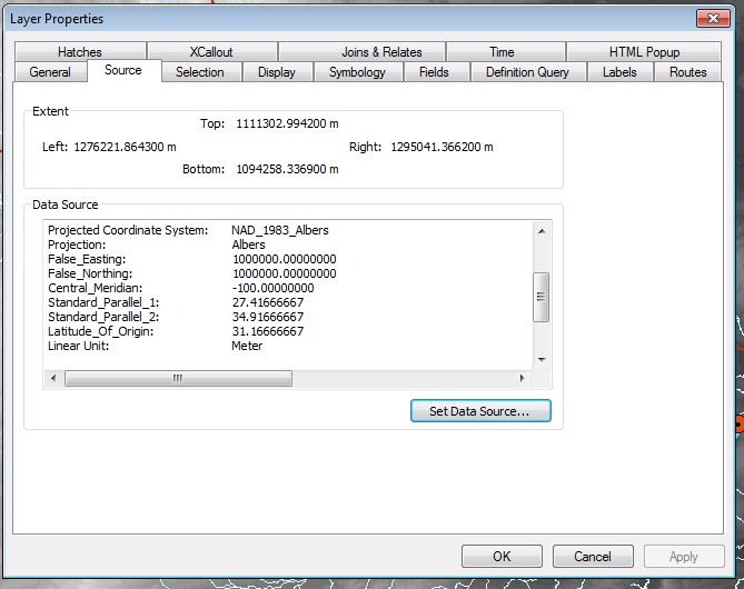
That is the NAD 1983 ... here
- Mark as New
- Bookmark
- Subscribe
- Mute
- Subscribe to RSS Feed
- Permalink
- Report Inappropriate Content
Ok, you need to use the Project Raster tool (ArcGIS Desktop ), to reproject your raster into the exact same projection as the polyline.
- Mark as New
- Bookmark
- Subscribe
- Mute
- Subscribe to RSS Feed
- Permalink
- Report Inappropriate Content
Thank you - I really appreciate the help!
I got them projected on the same datum and the linear units are correct now.
Now on to the slope porblems ...