- Home
- :
- All Communities
- :
- Industries
- :
- Natural Resources
- :
- Forestry
- :
- Forestry Questions
- :
- Re: ArcMAP Symbology
- Subscribe to RSS Feed
- Mark Topic as New
- Mark Topic as Read
- Float this Topic for Current User
- Bookmark
- Subscribe
- Mute
- Printer Friendly Page
- Mark as New
- Bookmark
- Subscribe
- Mute
- Subscribe to RSS Feed
- Permalink
- Report Inappropriate Content
Hello,
This is an ArcMAP 10.4.1 question. Is it possible to symbolize using one value field; then color and size that symbol using another field? I am trying to display a set of surface geochem data. I would like to choose a different symbol for each rock type then color and size that symbol depending on its gold value. So far I am able to symbolize each rock type differently and size each symbol according to its gold value, but I am not able to choose different colors for the increasing gold values. I am using the multiple attributes function in symbology.
Thanks
Ryan
Solved! Go to Solution.
- Mark as New
- Bookmark
- Subscribe
- Mute
- Subscribe to RSS Feed
- Permalink
- Report Inappropriate Content
Once I resolve some issues I'm experiencing with my license server I will mimic some data and see how far I get.
- Mark as New
- Bookmark
- Subscribe
- Mute
- Subscribe to RSS Feed
- Permalink
- Report Inappropriate Content
OK, so I think it will be possible, but it will require some manual configuration:

I generated a random dataset with this structure:

The SoilValueClass is a classification of the SoilValues into 5 classes.
I used two field as Value fields (Soil and SoilValueClass):

I manually assigned the colors, since applying the ramp will assign blue to "igneous, 1" and red to the end "Soil, 5" which is not what you want. So I selected "igneous, 1", "metamorphic,1", etc up to "soil, 1" and assigned the blue color and for every "SoilValueClass" value a different color in the range of blue to red.
The Symbol Size was defined by the field SoilValues:
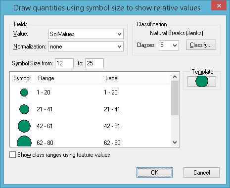
The legend is very, very, very long...

- Mark as New
- Bookmark
- Subscribe
- Mute
- Subscribe to RSS Feed
- Permalink
- Report Inappropriate Content
Nice work, how did you populate the "soilvalueclass" field? Is it possible to add a field and populate it in Arc or do I need to do that in an excel file?
- Mark as New
- Bookmark
- Subscribe
- Mute
- Subscribe to RSS Feed
- Permalink
- Report Inappropriate Content
You can use the FieldCalculator (Making simple field calculations—Help | ArcGIS for Desktop ) to fill the new classified field:
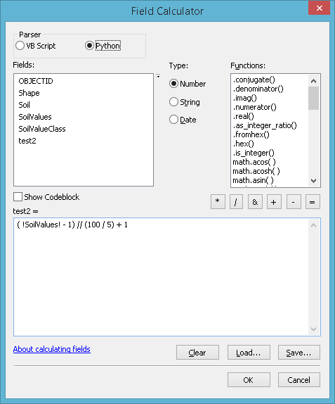
In this example I am classifying the Field "!SoilValues!" into 5 classes and my maximum value is 100:
( !SoilValues! - 1) // (100 / 5) + 1
Please note that "Python" is selected as Parser.
If you can share the range of values you have, I can adapt the formula for you.
- Mark as New
- Bookmark
- Subscribe
- Mute
- Subscribe to RSS Feed
- Permalink
- Report Inappropriate Content
That would be great. The ranges I am using are visible in the image I posted earlier.
Thank you very much
- Mark as New
- Bookmark
- Subscribe
- Mute
- Subscribe to RSS Feed
- Permalink
- Report Inappropriate Content
In case you are referring to these "Quantile" ranges:
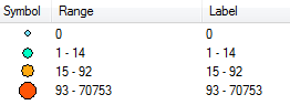
... it would require a slightly different approach.
You could do this:
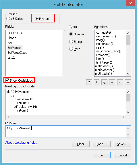
Select Python as Parser, activate the option "Show Codeblock"
Past the code below in the "Pre-Logic Script Code":
def Clfy(value):
try:
if value == 0:
return 0
elif value <= 14:
return 1
elif value <= 92:
return 2
else:
return 3
except:
return -1and enter the expression:
Clfy( !SoilValues! )
... where "SoilValues" should be replaced by the name of your field with unclassified values.
- Mark as New
- Bookmark
- Subscribe
- Mute
- Subscribe to RSS Feed
- Permalink
- Report Inappropriate Content
Well, congrats, you're hired!
Thank you very much for your persistence and ArcMAP skills. Your help has been greatly appreciated.
Have a great day
- Mark as New
- Bookmark
- Subscribe
- Mute
- Subscribe to RSS Feed
- Permalink
- Report Inappropriate Content
You're welcome! Could you mark the post that answered your question as the "Correct Answer"?
- « Previous
-
- 1
- 2
- Next »
- « Previous
-
- 1
- 2
- Next »