- Home
- :
- All Communities
- :
- Products
- :
- Geoprocessing
- :
- Geoprocessing Questions
- :
- Creating a model with modelbuilder
- Subscribe to RSS Feed
- Mark Topic as New
- Mark Topic as Read
- Float this Topic for Current User
- Bookmark
- Subscribe
- Mute
- Printer Friendly Page
- Mark as New
- Bookmark
- Subscribe
- Mute
- Subscribe to RSS Feed
- Permalink
- Report Inappropriate Content
I am exporting attributes out from a web application to Excel spreadsheets and then displaying those points in my map. I would like to build a model which will help me automate this process and was wondering if there is a geoprocessing tool which does the same thing as Display XY does in the popup menu?
The process I am using is Export the records out from the Web Application map to an Excel spreadsheet and then bring the Excel spreadsheet into my map and right click it to bring up the Display XY option. Once I have the points displayed on my map I copy and paste the points into my Feature class which holds all the attributes for the point feature.
Any help would be appreaciated
Solved! Go to Solution.
Accepted Solutions
- Mark as New
- Bookmark
- Subscribe
- Mute
- Subscribe to RSS Feed
- Permalink
- Report Inappropriate Content
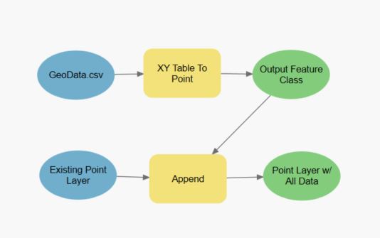
I haven't tried every step of this, but I think you could create a model that does this in just two steps. First, use the XY Table to Point function on the .csv you have. Second, you can use the Append tool to add it to the feature class you already have. You'll need to figure out field matching in Append, but other than that, if I'm understanding what you're looking for, it should be easy peasy. I've attached a pic of how I would make a model to do what you're asking.
- Mark as New
- Bookmark
- Subscribe
- Mute
- Subscribe to RSS Feed
- Permalink
- Report Inappropriate Content
I don't do python, but I think this can be automated with a python script. Have you thought of using python? I'm sure there are samples that would help write a script for your process. If you want (or need) to stick with Model Builder (in ArcMap, presumably?), then perhaps you can use the Excel to Table tool along with Add XY Coordinates tool and then perhaps the Append or Copy tool?
Good luck!
- Mark as New
- Bookmark
- Subscribe
- Mute
- Subscribe to RSS Feed
- Permalink
- Report Inappropriate Content
I haven't tried every step of this, but I think you could create a model that does this in just two steps. First, use the XY Table to Point function on the .csv you have. Second, you can use the Append tool to add it to the feature class you already have. You'll need to figure out field matching in Append, but other than that, if I'm understanding what you're looking for, it should be easy peasy. I've attached a pic of how I would make a model to do what you're asking.
- Mark as New
- Bookmark
- Subscribe
- Mute
- Subscribe to RSS Feed
- Permalink
- Report Inappropriate Content
Thanks for the reply! Right after I posted the message, I found the XY Table to Point tool that looks like it would accomplish what I am trying to do. I am currently in the process of putting the model together.
Thanks
- Mark as New
- Bookmark
- Subscribe
- Mute
- Subscribe to RSS Feed
- Permalink
- Report Inappropriate Content
Can you not just consume the feature or map service from the app?