- Home
- :
- All Communities
- :
- Products
- :
- Geoprocessing
- :
- Geoprocessing Questions
- :
- Creating expanded network from points?
- Subscribe to RSS Feed
- Mark Topic as New
- Mark Topic as Read
- Float this Topic for Current User
- Bookmark
- Subscribe
- Mute
- Printer Friendly Page
- Mark as New
- Bookmark
- Subscribe
- Mute
- Subscribe to RSS Feed
- Permalink
- Report Inappropriate Content
I have a set of points as shown in the picture below. What I want to do is to create a series of crisscrossing lines like the second picture below. Is there any way to do this without having to resort to manual line-drawing? I have tried many ways from the "points to line" function to fishnets, but none of them seem to work! Any tips to make this easier would be much appreciated too! Thanks!


Solved! Go to Solution.
Accepted Solutions
- Mark as New
- Bookmark
- Subscribe
- Mute
- Subscribe to RSS Feed
- Permalink
- Report Inappropriate Content
There is an easy solution but with many steps.
Frist , you will measure the diagonal line between the two closer points. (as the picture ).

2- Use Add XY Coordinates to your point feature class .
3- Use Spatial Join and make the join feature class and target feature class is your point feature class (same layer). and Join operation one to many , and match option within a distance and the distance is the diagonal distance the measured in step 1.( as the picture)
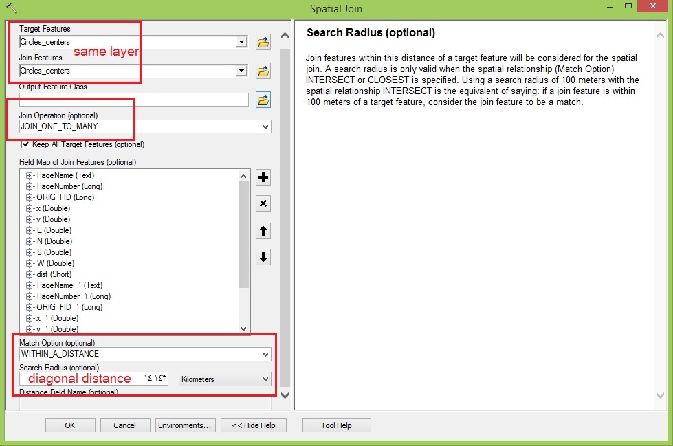
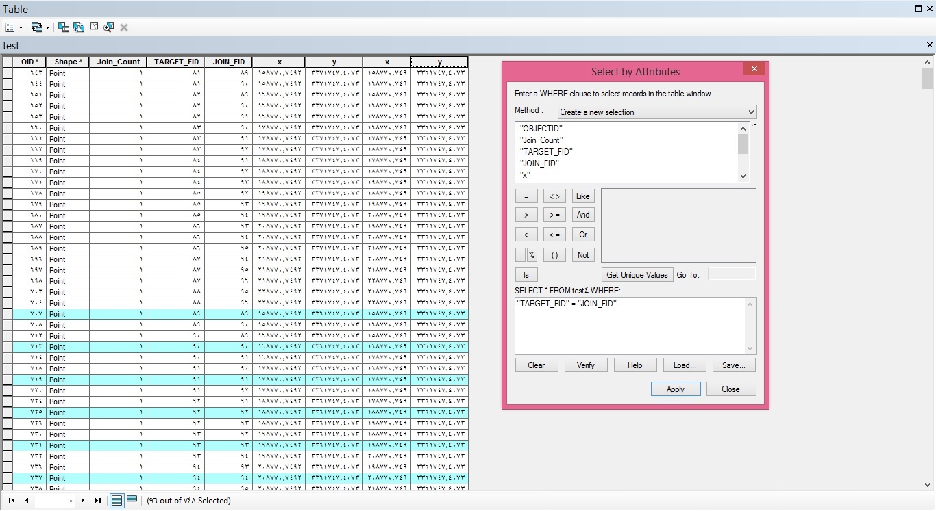
4-After Join we should delete the join with the same point , so we will go to attribute table and make a query ("TARGET_FID" = "JOIN_FID") to select those points then delete them. (as the picture)
5- The main operation in this solution is using XY To Line tool. and define Start X field and Start Field as the x and y coordinates of target fields and End X field and End Field as the x and y coordinates of Join fields (Vice versa). and define same spatial reference.

6-Finaly , you will get the square and diagonal lines. as you want. But you will need to Use Dissolve tool, to remove the duplicate lines .
- Mark as New
- Bookmark
- Subscribe
- Mute
- Subscribe to RSS Feed
- Permalink
- Report Inappropriate Content
How are your points generated? The method of constructing them could be exploited to assist in connecting the points. Using the nearest X points will fail in many corner cases unless a specific rule set is used to ensure that once a line is formed, that point is removed from the candidate list of points to connect to. I wrote some base code to make point connections but I hadn't considered this possible use, so even it fails since the algorithm is based on connecting the closest but not with removal once it has been used 'n-times' (if you want to pull out some of the base code to modify, it is here )
- Mark as New
- Bookmark
- Subscribe
- Mute
- Subscribe to RSS Feed
- Permalink
- Report Inappropriate Content
The points were created by generating tessellations (square) and converting them into points. I am actually trying to replicate an expanded network grid for a continuous space siting problem in vector format. I can easily create the square grid lines but have had difficulty creating the diagonal lines. Thanks for the link though, I'd see what I can do with it!
- Mark as New
- Bookmark
- Subscribe
- Mute
- Subscribe to RSS Feed
- Permalink
- Report Inappropriate Content
I thought about a simple Delaunay triangulation but that will only return one of the diagonals. I couldn't get consistent results using the code link I posted, that is why I thought of modifying the base code to form the diagonals in a predictable fashion. Have a go yourself if you want, and I will think on it some more.
- Mark as New
- Bookmark
- Subscribe
- Mute
- Subscribe to RSS Feed
- Permalink
- Report Inappropriate Content
There is an easy solution but with many steps.
Frist , you will measure the diagonal line between the two closer points. (as the picture ).
2- Use Add XY Coordinates to your point feature class .
3- Use Spatial Join and make the join feature class and target feature class is your point feature class (same layer). and Join operation one to many , and match option within a distance and the distance is the diagonal distance the measured in step 1.( as the picture)
4-After Join we should delete the join with the same point , so we will go to attribute table and make a query ("TARGET_FID" = "JOIN_FID") to select those points then delete them. (as the picture)
5- The main operation in this solution is using XY To Line tool. and define Start X field and Start Field as the x and y coordinates of target fields and End X field and End Field as the x and y coordinates of Join fields (Vice versa). and define same spatial reference.
6-Finaly , you will get the square and diagonal lines. as you want. But you will need to Use Dissolve tool, to remove the duplicate lines .
- Mark as New
- Bookmark
- Subscribe
- Mute
- Subscribe to RSS Feed
- Permalink
- Report Inappropriate Content
This worked fantastically! Thanks so much for taking the time to come up with this! 