- Home
- :
- All Communities
- :
- User Groups
- :
- GIS Manager's Group
- :
- Questions
- :
- Re: Small City Strategy
- Subscribe to RSS Feed
- Mark Topic as New
- Mark Topic as Read
- Float this Topic for Current User
- Bookmark
- Subscribe
- Mute
- Printer Friendly Page
Small City Strategy
- Mark as New
- Bookmark
- Subscribe
- Mute
- Subscribe to RSS Feed
- Permalink
- Report Inappropriate Content
I just took a new role as GIS Coordinator in a small city. Noone knows what my job is and there is no direction. I'm new to GIS so I'm lacking that experience as well. I've been reading articles about Strategy and how to create one for an organization. Is there any way to get examples of other organizations GIS Strategy especially if they are from other small cities to help give me a framework on what we are looking to develop?
- Mark as New
- Bookmark
- Subscribe
- Mute
- Subscribe to RSS Feed
- Permalink
- Report Inappropriate Content
Derek: If you would like to discuss contact me at swardurp@alphaetta.ga.us. Most important items:
Infrastructure, software requirements, dataset requirements (priority datasets), in-house outreach, and community outreach.
- Mark as New
- Bookmark
- Subscribe
- Mute
- Subscribe to RSS Feed
- Permalink
- Report Inappropriate Content
Derek,
Congrats and condolenses on your new role. I can say that because I've been there. It's tough work to get GIS and its benefits accepted as a reason to change long-held beliefs of people that have much more experience than you. Find an executive sponsor to help establish the urgency to change/improve your city's operations - City Manager? Dept. Head? If you're embedded with a depatment you may have to live in that ecosystem for a while before branching out. Being under the city manager is preferred over a department because, with the right city vision, GIS will be expected to deliver organizational benefits and departments will need to leverage the technology, data structures and information sharing that GIS can bring. You may not be able to effect this level of change for a while and that's OK, find quick wins that demonstrate the benefits and value you and GIS can bring - document them, communicate them broadly so as to find friendly programs that want the benefits you can deliver with GIS. Search ArcUser for GIS ROI to find ways to prove/share your GIS results. Use other GIS program's strategic plans as templates for a plan, but know that your city's needs/priorities must come from your agency.
- Mark as New
- Bookmark
- Subscribe
- Mute
- Subscribe to RSS Feed
- Permalink
- Report Inappropriate Content
I was brought into a county to work the bugs out of an unorganized GIS. I spent 3 years repairing data and building rapport with the people in the GIS silos. I was my own department when hired. Under new management, I was placed in the IT Department. Being placed in an established department properly aligned the GIS to move forward. Management never fully committed to the GIS Department because they didn't know what to do with it or me for that matter.
No one in Management or IT know ANYTHING about GIS so although I am not a Department Head any longer, I am still responsible for leading out and establishing a viable GIS in Lancaster County. Management was abrupt in their dealings with me in demotion and salary reduction. I'm just about over that fiasco. Bottom line, GIS now has representation of sorts and can move forward, being accepted by management.
I have found that getting in the proper spot to be recognized by Management is the key. From there comes the governance document. Once the corporate plan is established, then the GIS moves ahead. Getting the data correct with documentation is also a must. Your GIS has to be reliable. Only then can it become set out to be used by the public.
The 3 items I found useful are the 2 attached documents and this link https://www.esri.com/about/newsroom/arcuser/what-makes-an-enterprise-gis-successful/.
Stick with it.
Jim
- Mark as New
- Bookmark
- Subscribe
- Mute
- Subscribe to RSS Feed
- Permalink
- Report Inappropriate Content
hi, Jim.
I don't see the attachments that you mentioned. Would you be willing to repost with the attachments?
Thank you!
- Mark as New
- Bookmark
- Subscribe
- Mute
- Subscribe to RSS Feed
- Permalink
- Report Inappropriate Content
Hi Derek, welcome to the wonderful world of GIS! I'd also be glad to share my experiences. mnorthey@ocalafl.gov Initial thoughts...a great place to start is to meet with others that use GIS in your city and find out what they need. Some departments may already know what they need, others may not have the resources, so meeting with those directors and finding out what their visions are is also helpful. Find out what your County is doing with GIS. Reach out to your Esri rep, they can help get you connected if you don't know your neighbors and they may also know what your neighboring cities, counties are doing. You may be able to work with them rather than reinventing the wheel.
- Mark as New
- Bookmark
- Subscribe
- Mute
- Subscribe to RSS Feed
- Permalink
- Report Inappropriate Content
This sounds like a great opportunity. If no one knows what your job is and no direction, then you have a lot of leeway to make it what you want.
I took a job with the same title for a small town of 55,000 about a decade ago. It was a brand new position for the town. My boss and council had some general ideas of what they wanted from me in the position, but no clear direction on how to get there. I found a great first step is to meet with each department you are to serve (Public Works, Planning, Police, Fire, Parks, etc...) and find out what they want from their GIS, what do they currently have for data and personnel, and get a feel for each department's workflow needs and limitations. In doing so, you can make allies, likely discover personnel who are already using GIS in some capacity, and develop a strategy that targets specific, quantifiable needs. This greatly helps secure buy-in from those departments, which is critical for success.
Good luck!
- Mark as New
- Bookmark
- Subscribe
- Mute
- Subscribe to RSS Feed
- Permalink
- Report Inappropriate Content
Thanks everyone for all the great advice. When I say small city, we are only 14.5k people. I've been meeting with other departments like many people have suggested but I think I will start trying to understand each department's strategy and purpose and pain points in addition to their GIS struggles. Our last GIS Coordinator left on bad terms with the City Manager, but we have a new Manager starting next week. I hope to meet with him early to establish some top level support. I've already knocked off some quick hit fixes and updates and for the most part I think people are receptive to GIS, but usually as an afterthought.
- Mark as New
- Bookmark
- Subscribe
- Mute
- Subscribe to RSS Feed
- Permalink
- Report Inappropriate Content
Hi @DerekBernard, you've gotten great advice here to move forward. This article may spark useful ideas on getting department leaders interested in how GIS could support their priorities: https://www.esri.com/about/newsroom/arcuser/lascruces/.
- Mark as New
- Bookmark
- Subscribe
- Mute
- Subscribe to RSS Feed
- Permalink
- Report Inappropriate Content
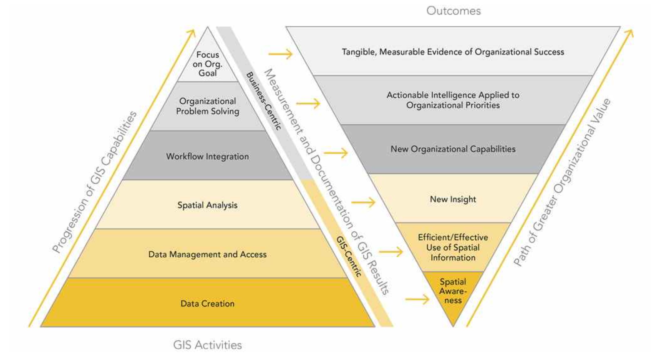
I would recommend you reach out to Marvin Davis (https://www.linkedin.com/in/marvin-davis-373a0b89/) and Robert Hawks (https://www.linkedin.com/in/robert-hawks-gisp-49556577/). Both of them have been successful in building GIS programs at cities smaller than yours.
In a nutshell, the graphic below is a good way to think about your mission. Build relationships with those in charge of meeting organizational goals. Find out from them what their challenges are. Implement sustainable GIS solutions using configurable, commercial-off-the-shelf (COTS) software, like ArcGIS Solutions, following best practices. Be sure to document and publicize your successes (business value).
