- Home
- :
- All Communities
- :
- Products
- :
- Imagery and Remote Sensing
- :
- Imagery Questions
- :
- Re: ArcGIS 10.2.2 Mosaic Dataset -- Overviews not ...
- Subscribe to RSS Feed
- Mark Topic as New
- Mark Topic as Read
- Float this Topic for Current User
- Bookmark
- Subscribe
- Mute
- Printer Friendly Page
ArcGIS 10.2.2 Mosaic Dataset -- Overviews not generated/do not display
- Mark as New
- Bookmark
- Subscribe
- Mute
- Subscribe to RSS Feed
- Permalink
- Report Inappropriate Content
I'm having trouble building a mosaic dataset with a particular set of preprocessed MrSID images.
When I add rasters to a freshly created mosaic dataset, built with the same projection as that of the imagery, I get the following:

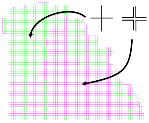
You can see that the footprints appear to have been added correctly, but something is clearly wrong with the boundary.
This is because some preprocessed images within the mosaic have been correctly aligned, while others have not. This is a fault of the imagery, not the mosaic dataset. You can see the gaps in the image below on the left; they're smaller than a single pixel in one of the images, so when you zoom out they are invisible, but when the footprints and boundary are built they stand out like a sore thumb.

I believe this is causing an issue when generating overviews: after rebuilding footprints and the boundary, then recalculating item visibility and defining and building overviews (all with the default settings), this is the result:

Only 5 overviews are generated at a scale that is visible when zoomed to the extent of the dataset (the attribute table in the image has been sorted by descending MinPS value). Overviews are built at the lower levels in the "empty" sections of the mosaic, but their MaxPS values are such that they won't display at this scale. The levels layer is below. You can see that level 2 contains the overviews that appear at full extent.

After analyzing the dataset, these are the pertinent errors/warnings:
Error 70124: the SHAPE field of the mosaic dataset contains invalid geometry
Warning 71118: the boundary has too many vertices
Warning 71119: the footprint contains too many vertices
Repairing the geometry takes care of error 70124, while rebuilding the boundary using the Envelope simplification method solves warning 71118.
However, after synchronizing the mosaic dataset to fix warning 71119, error 70124 reappears.
Rebuilding overviews after taking any one of these steps does not result in a change in the number or display of any of the overviews.
I'm really not sure how to proceed. Are there settings I can change to modify how the footprints are created? Has anyone else run into this sort of thing? If so, how did you deal with it?
Thanks for the help!
Solved! Go to Solution.
Accepted Solutions
- Mark as New
- Bookmark
- Subscribe
- Mute
- Subscribe to RSS Feed
- Permalink
- Report Inappropriate Content
DISCLAIMER: There may be a better solution than what I describe below.
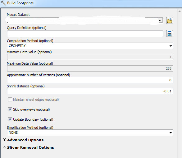
I have seen this issue a few times recently and one approach that helps is to rebuild the footprints using a negative shrink distance so that the footprints expand to cover the gaps between the source images. There is also an option in the Build Footprints tool to update the boundary. Employing this option while expanding the footprints to cover the gaps results in a properly generated boundary. With a properly generated boundary you should be able to successfully build overviews. Here is an example procedure:
1. Remove any existing overviews using a selection and the Remove Rasters From Mosaic Dataset tool.
2. Rebuild the footprints and boundary using the Build Footprints tool. Use a shrink distance value that will expand the footprint enough to cover the gap (but the value should be entered as a negative number).
3. Verify the boundary appears correct (i.e., it should be a boundary of the mosaic dataset and not of the individual datasets).
4. Build overviews.
Here is an example of the settings I have used to correct the issue.
- Mark as New
- Bookmark
- Subscribe
- Mute
- Subscribe to RSS Feed
- Permalink
- Report Inappropriate Content
DISCLAIMER: There may be a better solution than what I describe below.
I have seen this issue a few times recently and one approach that helps is to rebuild the footprints using a negative shrink distance so that the footprints expand to cover the gaps between the source images. There is also an option in the Build Footprints tool to update the boundary. Employing this option while expanding the footprints to cover the gaps results in a properly generated boundary. With a properly generated boundary you should be able to successfully build overviews. Here is an example procedure:
1. Remove any existing overviews using a selection and the Remove Rasters From Mosaic Dataset tool.
2. Rebuild the footprints and boundary using the Build Footprints tool. Use a shrink distance value that will expand the footprint enough to cover the gap (but the value should be entered as a negative number).
3. Verify the boundary appears correct (i.e., it should be a boundary of the mosaic dataset and not of the individual datasets).
4. Build overviews.
Here is an example of the settings I have used to correct the issue.
- Mark as New
- Bookmark
- Subscribe
- Mute
- Subscribe to RSS Feed
- Permalink
- Report Inappropriate Content
I believe the source of your issue is an accuracy in the definition of the pixel size of the data.
Looking at your graphics is would appear that the size of each raster is very slightly too small and so there is a gap between the tiles. Double check the cell size of the source data. You may find there is a rounding eg 2.667 vs 2.6666666667. After 1000 pixels the difference adds up.
One way to resolve this is to create World Files for each of the MrSID files (.sdw) which are text files. Then edit the pixel size defined in them to be the correct values. Then recreate the mosaic dataset after setting (ArcMap Options, Raster,
You should now find that the gaps disappear (and the issues you are facing)
The gaps in the image will cause another issue in the you will get NoData values when you zoom in which will reduce performance.
As Gabriel mentions you can also rebuild the footprint with a negative shrink distance.Then build the boundary and then rebuild the footprints without the negative shrink.
Another solution is to use Merge. You can select set of image (a few hundred) and do a merge which will replace the rasters with a single raster. There some fixed in merge at 10.3 so I might not suggest it as a good solution in your case.
Also note when creating overviews. I often find it better to use the Define Overview followed by BuildOverview. In Define overview you can define the pixel size of the initial overview. Typically I would set this to a value that is about width of typical tile/1000 and then round the number to something sensible. If then data is uniform as in this case you can set the 'Force Overview Tiles'. I also typically set the overview sampling factor to 2. (The resulting service is a bit faster, although takes a bit more space.)
- Mark as New
- Bookmark
- Subscribe
- Mute
- Subscribe to RSS Feed
- Permalink
- Report Inappropriate Content
Thanks for all the great suggestions Peter. I hadn't thought about running Build Footprints again with the "Update Boundary" parameter disabled to reset the footprints to the correct geometry.
- Mark as New
- Bookmark
- Subscribe
- Mute
- Subscribe to RSS Feed
- Permalink
- Report Inappropriate Content
Thanks so much for the fast replies and helpful information! I'm in the process of trying these suggestions and will post my results as soon as I can.
- Mark as New
- Bookmark
- Subscribe
- Mute
- Subscribe to RSS Feed
- Permalink
- Report Inappropriate Content
After multiple attempts, I was finally able to correctly build overviews using the black magic of negative shrink values. In my case, it required increasing the shrink distance to -1.6, twice the width of the image pixels!

Thankfully, there were no issues with rounding of pixel values: they were all set to 0.8 feet, so I didn't need to alter the world files. Also, rebuilding the footprints with the "Update Boundary" parameter disabled after achieving the correct boundary did not solve the problem. This was the output after that operation:

Thanks again for everyone's help and suggestions!