- Home
- :
- All Communities
- :
- Products
- :
- Imagery and Remote Sensing
- :
- Imagery Questions
- :
- Is there any advantage to creating pyramids for JP...
- Subscribe to RSS Feed
- Mark Topic as New
- Mark Topic as Read
- Float this Topic for Current User
- Bookmark
- Subscribe
- Mute
- Printer Friendly Page
Is there any advantage to creating pyramids for JPEG2000 raster format?
- Mark as New
- Bookmark
- Subscribe
- Mute
- Subscribe to RSS Feed
- Permalink
- Report Inappropriate Content
- JPEG2000 raster format has internal pyramids.*
- With ArcGIS versions 10.x, pyramids can be built for the JPEG2000 format. It seems this wasn't possible with 9.x versions of ArcGIS**
- Is there a reason why only for the JPEG2000 format pyramids can be created, but for other raster formats with internal pyramids like ECW & MrSID, pyramids cannot be created?
References
* Raster pyramids—Help | ArcGIS for Desktop
**34490 - Why can't pyramids for ECW, JPEG 2000, or MrSID files be built?
- Mark as New
- Bookmark
- Subscribe
- Mute
- Subscribe to RSS Feed
- Permalink
- Report Inappropriate Content
First of all, all wavelet-compressed raster file formats like ECW, MrSID, and JPEG 2000, will have internal pyramids. This indicates that pyramids cannot be created by any solution packages, including ArcGIS…
Secondly, let’s argue one statement on JPEG 2000 at http://desktop.arcgis.com/en/desktop/latest/manage-data/raster-and-images/raster-pyramids.htm :
(With ArcGIS), you can create pyramids for JPEG 2000. Geodatabase rasters with wavelet compression can also have pyramids built.
Personally, it is a confusing statement. In fact, when running the GP tool ‘Building Pyramids” on JPEG 2000, the resulted JP2 does not have the associated .ovr file. Also, the result JP2 does not have any performance improvement…
Finally, on JPEG2000 standard (http://www.jpeg.org/jpeg2000/applications.html ), it is well known that many solution vendors have different implementations on this standard JPEG2000; even though their JP2 can be compatible with each other…This fact indicates one implementation may have more advantages over others… However, many computer solution vendors extend the above JPEG2000 standard differently for different purposes.
For example, ERDAS Imagine supports the following supplements to the JPEDG2000 standard via the “Advanced” parameters:
Tile Dimensions, Precinct Dimensions, Progression Order (RPCL - Fastest loading from networks; Progression by resolution; LRCP - Slower loading from networks except when datastream is sent by quality layer; Progression by quality layer; RLCP- Faster loading from networks than LRCP option; Progression by resolution, and then by quality layer)…
- Mark as New
- Bookmark
- Subscribe
- Mute
- Subscribe to RSS Feed
- Permalink
- Report Inappropriate Content
Thank you for your reply. But consider the following:
Quote "Personally, it is a confusing statement. In fact, when running the GP tool ‘Building Pyramids” on JPEG 2000, the resulted JP2 does not have the associated .ovr file. Also, the result JP2 does not have any performance improvement…"
Unquote
My attempts to create pyramids for a JPEG2000 raster format have always yielded a .ovr file. And there is a visual difference and there seems to be a performance difference when using the file with a pyramid created.
I have about 30 1 to 2 GB rasters all in JPEG2000 raster format and since the pyramid creation takes considerable time (about an hour per raster with my resources), I'd like to know if there is any value in having them created. These rasters may later be present in a mosaic dataset which also uses pyramids to reduce overview creation - another reason why knowing if there's any reason why only the JPEG2000 raster format that comes with internal pyramids allows pyramid creation with ArcGIS.
- Mark as New
- Bookmark
- Subscribe
- Mute
- Subscribe to RSS Feed
- Permalink
- Report Inappropriate Content
As you mentioned, you can generate an .ovr file for JPEG2000 and obtained the performance improvement. If correct, it is an advantage with pyramids for a JPEG2000.
++++++++++++++++++
In practice, not sure why I couldn't reproduce the statement (generating an .ovr file for JPEG2000) with ArcGIS (in all my office & home workstations).
In addition, in theory, it is challenging for me to understand how the generation of pyramids for a JPEG2000 can improve performance…
pls share if anyone has any references on this...
- Mark as New
- Bookmark
- Subscribe
- Mute
- Subscribe to RSS Feed
- Permalink
- Report Inappropriate Content
Perhaps as you've stated 'it is well known that many solution vendors have different implementations on this standard JPEG2000', Maybe the implementation of JPEG2000 raster files I have could be producing an ovr file and the implementation of JPEG2000 of your raster file does not result in a ovr file if the ArcGIS create pyramids tool is run. It's speculation as of now. 
- Mark as New
- Bookmark
- Subscribe
- Mute
- Subscribe to RSS Feed
- Permalink
- Report Inappropriate Content
What do you mean?
...It's speculation as of now.
+++++++++++++
If the pyramids of any JP2 file can be generated, personally, the implementation of wavelet-based JPEG2000 (standard) might be not optimal...
Two years ago, we have generated and compared many JP2 files by different GIS & remote sensing solution vendors on JPEG2000, including PCI, ERDAS Imagine, ArcGIS, ENVI, ...The initial results (usually giving us with different sizes, diffierent performances, etc.) indicate the following: many solution vendors have different implementations on this standard JPEG2000...
Here worth to mention that, when generating JP2, we usually set up the parameters with “lossless” (if the implementation in JPEG2000 is available).
- Mark as New
- Bookmark
- Subscribe
- Mute
- Subscribe to RSS Feed
- Permalink
- Report Inappropriate Content
Well I was being presumptuous with what I said in my previous post, that perhaps there's something different between the JPEG2000 files we are working with, which causes one to have .ovr when running the create pyramids tool. There's no proof that our files are different. Hence the speculation.
- Mark as New
- Bookmark
- Subscribe
- Mute
- Subscribe to RSS Feed
- Permalink
- Report Inappropriate Content
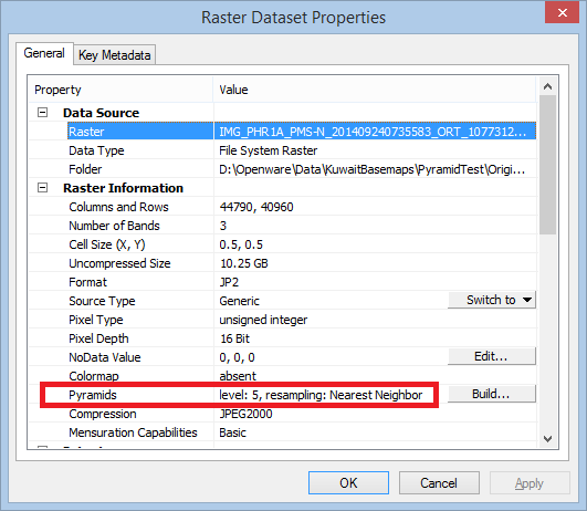
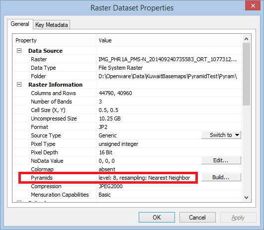
Here are two images showing raster properties before and after creating pyramids with JPEG2000 format. Clearly, the pyramid creation is adding more pyramid levels.
Before pyramid creation:
After pyramid creation:
cc: larry zhang
- Mark as New
- Bookmark
- Subscribe
- Mute
- Subscribe to RSS Feed
- Permalink
- Report Inappropriate Content
It makes sense to me now.
With ArcGIS, if JP2 images having low Pyramid levels, the GP tool can help increase ...
Thx,
+++++++++++++
In fact, with Wavelet-based 'lossless' compression algorithms (MrSID, ECW, or JP2), users usually create 10 levels of Pyramids by default, in most Remote Sensing packages like ERDAS Imagine.