- Home
- :
- All Communities
- :
- Products
- :
- Imagery and Remote Sensing
- :
- Imagery Questions
- :
- Landsat 8 color not correct, Any ideas?
- Subscribe to RSS Feed
- Mark Topic as New
- Mark Topic as Read
- Float this Topic for Current User
- Bookmark
- Subscribe
- Mute
- Printer Friendly Page
Landsat 8 color not correct, Any ideas?
- Mark as New
- Bookmark
- Subscribe
- Mute
- Subscribe to RSS Feed
- Permalink
- Report Inappropriate Content

I have Arcmap 10.0.I am not able to take the Glovis images and get them to look like a true satellite image through Arcmap. Perhaps is it easier to do through a 3rd party software.., I'm really struggling with how to make it look green instead of really dark.
Is there one image of the Bundle that is supposed to make this process simpler, when downloaded it hits 500 megs, but all pics overlap. Any help appreciated

- Mark as New
- Bookmark
- Subscribe
- Mute
- Subscribe to RSS Feed
- Permalink
- Report Inappropriate Content
Hi Gary,
If I am understanding your problem correctly, you might try using the Composite Bands tool to combine all the individual bands into a single multi-band dataset. Here is a help document on the tool: Composite Bands—Help | ArcGIS for Desktop
- Mark as New
- Bookmark
- Subscribe
- Mute
- Subscribe to RSS Feed
- Permalink
- Report Inappropriate Content
Hi Gabriel:
Thank You!, I did get it working. The bands available 1-13, I tried several combinations to get the greenish result I'm familiar with for photography.Band 3 for red, band 5 for green and band 9 for blue.
- Mark as New
- Bookmark
- Subscribe
- Mute
- Subscribe to RSS Feed
- Permalink
- Report Inappropriate Content
Here are a few blog posts on Landsat band combinations that you may find useful. Also, the Landsat Advisory Group has a questionnaire they'd like Landsat users to fill out. I posted the link to it on GeoNet yesterday. I'll repeat it below. If you get a couple of minutes, please go on and respond as they will use the results for deciding future missions.
Landsat 8 band combinations | ArcGIS Blog
Accessing Landsat 8 band combinations in ArcGIS Online | ArcGIS Blog
Band Combinations for Landsat 8 | ArcGIS Blog
https://www.surveymonkey.com/s/Landsat_requirements_analysis
- Mark as New
- Bookmark
- Subscribe
- Mute
- Subscribe to RSS Feed
- Permalink
- Report Inappropriate Content
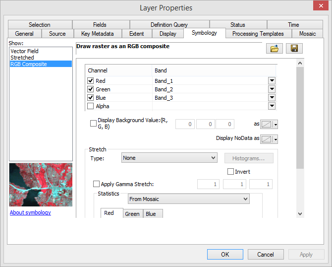
It looks like that the stretch renderer was applied. If you access the image layer properties from the ToC can you manually change the renderer in the display from Stretched to RGB Composite?