- Home
- :
- All Communities
- :
- Industries
- :
- Land Records and Valuation
- :
- Land Records and Valuation Questions
- :
- BUG-000087677
- Subscribe to RSS Feed
- Mark Topic as New
- Mark Topic as Read
- Float this Topic for Current User
- Bookmark
- Subscribe
- Mute
- Printer Friendly Page
BUG-000087677
- Mark as New
- Bookmark
- Subscribe
- Mute
- Subscribe to RSS Feed
- Permalink
- Report Inappropriate Content
I have run in to problems with this bug while working with our parcel fabric, I just wanted to let folks know to put off upgrading to 10.3.1 or warn you not install the Parcel Fabric General Maintenance patch if you have downloaded it.
Summit County, Utah
- Mark as New
- Bookmark
- Subscribe
- Mute
- Subscribe to RSS Feed
- Permalink
- Report Inappropriate Content
Jeff,
Note that there is a workaround for the problem as indicated in the bug description. I hope that this workaround can be used until the update is available. We're currently testing the fix, and working on publishing an updated patch for 10.3--it will be available as soon as possible. There will also be a 10.3.1 patch to follow that addresses this same problem. Apologies to all those affected.
-Tim
- Mark as New
- Bookmark
- Subscribe
- Mute
- Subscribe to RSS Feed
- Permalink
- Report Inappropriate Content
Tim,
I am aware of the workaround, and it does seem to be working although it is a pain. I just wanted to make folks aware of the issue - it took me quite a while to notice it was happening.
Summit County, Utah
- Mark as New
- Bookmark
- Subscribe
- Mute
- Subscribe to RSS Feed
- Permalink
- Report Inappropriate Content
Thanks Jeff. Did you notice the problem prior to saving edits, or do you now have instances of control points stored in the database that have had the incorrect unit conversion already applied? If you (or anyone reading this) have a large number of instances of the wrong control points stored in the database as a result of this problem, there is a way that these can be repaired.
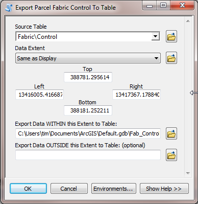
Since we know that the coordinates are getting a unit conversion applied, we can detect the control points that are well outside the proper extent, export them to a table (dropping some of the system fields), recalculate the X and Y fields by multiplying them by a scale factor, and then re-import them using the Control point Importer. Once it’s been determined that the process occurred correctly, then the control points that are in the wrong location can be deleted.
I’ve uploaded a toolbox to AGOL with a script for exporting the control.
Here are the steps to follow after downloading it:
- Drag the control fabric class that has the incorrect control points onto a new map.
- You should see two clusters of control points, one of the clusters being at the incorrect location
- Use the Zoom tool and zoom to the location of the incorrect control so that all are within the map extents
- In the toolbox double click the script called “Export Parcel Fabric Control To Table”
- Set the source table to be the Control layer
- For the Data Extent parameter, click the dropdown and pick “Same as Display”
- Choose the location for the exported table
- Click OK
- The table is added to the Table of Contents
- Open the Table
- Confirm that the X and Y values are well outside the correct range
- Right-click the X field column and click Field Calculator
If your original data is in US Feet then calculate as follows:
If your original data is in International Feet then calculate as follows:
- Do the same steps for the Y field column, and Calculate the
- Right-click the Fabric in the Catalog window, and click Import->Control Points
- Navigate to the table that you exported, and that you updated the coordinates on
- Accept the default values in the Control import wizard and then add the fabric to the map
- Confirm that the control points that had been changed are now back in the correct location
- If all’s OK, Start Editing, and go back to the incorrect control points, and delete them.
- Mark as New
- Bookmark
- Subscribe
- Mute
- Subscribe to RSS Feed
- Permalink
- Report Inappropriate Content
I did save edits before I knew about the workaround. I was deleting the faulty control points and replacing them with new ones where they belong. Now that I have the data frame set to the meter equivalent of my coordinate system it's not a problem. When I enter a control point, I have to switch the data frame back to feet.
Summit County, Utah