- Home
- :
- All Communities
- :
- User Groups
- :
- Local Government Solutions Users
- :
- Questions
- :
- What causes ArcGIS Online Parcel Drafter to not ca...
- Subscribe to RSS Feed
- Mark Topic as New
- Mark Topic as Read
- Float this Topic for Current User
- Bookmark
- Subscribe
- Mute
- Printer Friendly Page
What causes ArcGIS Online Parcel Drafter to not caluclate misclose or save parcels?
- Mark as New
- Bookmark
- Subscribe
- Mute
- Subscribe to RSS Feed
- Permalink
- Report Inappropriate Content
Hi all,
I've missed a step or a particular piece of the configuration while setting up the Parcel Drafter for Local Government solution using Web AppBuilder Dev. Edition. I loaded the required schema for parcel drafter lines and parcel drafter parcels into our enterprise GIS and included these in an AGS service with Feature Access enabled. I added these two layers (FeatureServer) and an additional Tax Parcel layer (MapServer) to the web map. I've configured the Parcel Drafter widget with these layers, with snapping on all 3 of the layers.
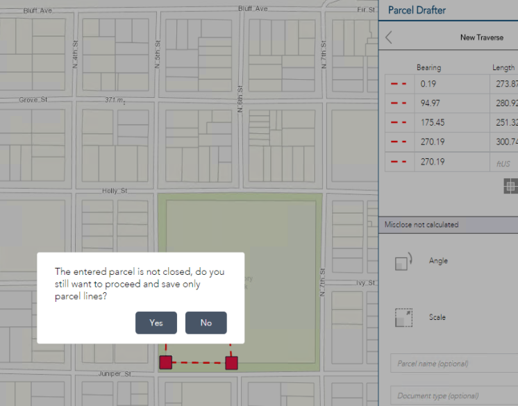
When entering a new traverse, the misclose is not calculated, and when I save a traverse I get the error "The entered parcel is not closed, do you still want to proceed and save only parcel lines?" However, my traverse end point is snapped to the starting point, so I have a complete polygon.
Has anyone experienced this issue and what can be done to resolve this? Like I mentioned, this is probably a simple misconfiguration on my end and any help is always appreciated.
Thanks all,
Kyle
- Mark as New
- Bookmark
- Subscribe
- Mute
- Subscribe to RSS Feed
- Permalink
- Report Inappropriate Content
Here is the link to the Parcel Drafter solution to demonstrate the issue: ArcGIS Web Application
- Mark as New
- Bookmark
- Subscribe
- Mute
- Subscribe to RSS Feed
- Permalink
- Report Inappropriate Content
Like our Parcel Editing Solution, the Parcel Drafter uses different line categories used to construct parcels. Connection lines (ones that you are entering) and Boundary lines are provided in the app. Connection lines are used to connect your start point (or origin point) to the point of beginning (POB). Boundary lines are used to define actual parcel boundaries, please update the traverse to set boundary lines and the app should calculate the mis-close if the line start and end fall within the mis-close tolerance set by the widget.
Thanks
Chris Buscaglia
Local Government Solutions Team
- Mark as New
- Bookmark
- Subscribe
- Mute
- Subscribe to RSS Feed
- Permalink
- Report Inappropriate Content
Aha! Yes!
Like I prefaced, it was my own user error. Crazy how things work great when one knows how to use them 
Thanks Chris, hope you're well!!
Kyle
- Mark as New
- Bookmark
- Subscribe
- Mute
- Subscribe to RSS Feed
- Permalink
- Report Inappropriate Content
Not solely user error - working on a video to describe the widget functions in more detail.
Glad it worked for you - let us know how the app works!
Chris
- Mark as New
- Bookmark
- Subscribe
- Mute
- Subscribe to RSS Feed
- Permalink
- Report Inappropriate Content
I am having the same issue but can't figure out where you change the setting for the traverse. Here are my settings: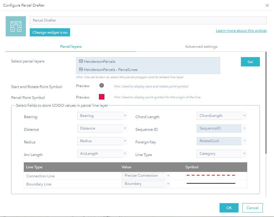
- Mark as New
- Bookmark
- Subscribe
- Mute
- Subscribe to RSS Feed
- Permalink
- Report Inappropriate Content
Hi Brian,
Your configuration looks good.
Without more information, I can provide 2 possible causes.
1. You have entered a parcel with only connection lines, you need to have boundary lines to form a closed parcel and calculate misclose.
2. You have not met the standard misclose tolerance set in the advanced settings.
Let me know if either of these solves the problem, if not, we can dig into it in more detail.
Chris
Government Solutions
- Mark as New
- Bookmark
- Subscribe
- Mute
- Subscribe to RSS Feed
- Permalink
- Report Inappropriate Content
I figured it out and my boundary now closes. But, I get an error message when I try to save it that it failed to save the polygon boundary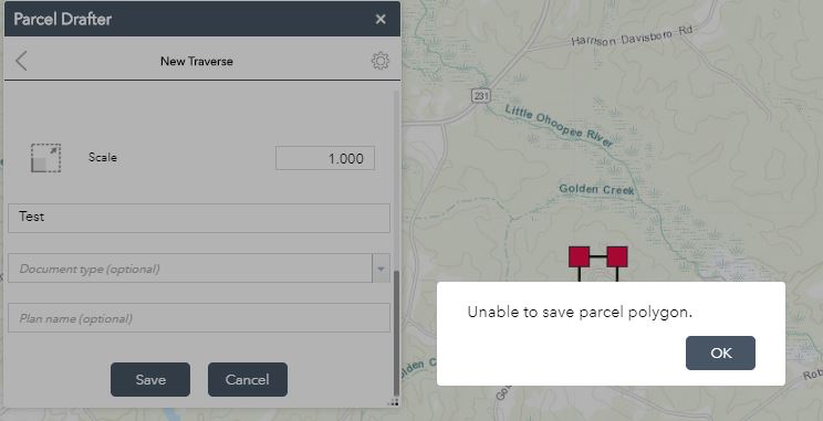
- Mark as New
- Bookmark
- Subscribe
- Mute
- Subscribe to RSS Feed
- Permalink
- Report Inappropriate Content
Brian -
Please open a support ticket and they can triage the issue.
Did you use our solution?