- Home
- :
- All Communities
- :
- Products
- :
- Mapping
- :
- Mapping Questions
- :
- Re: How to convert KML file to layer , on an alrad...
- Subscribe to RSS Feed
- Mark Topic as New
- Mark Topic as Read
- Float this Topic for Current User
- Bookmark
- Subscribe
- Mute
- Printer Friendly Page
How to convert KML file to layer , on an alrady existing map in arcgis
- Mark as New
- Bookmark
- Subscribe
- Mute
- Subscribe to RSS Feed
- Permalink
- Report Inappropriate Content
I have a map in arcGIS, and i want some kml data to be shown over that map. But if i convert kml to layer, the data is not visible on that map. Both the layers can be seen separately by "zoom to layer" option but not simultaneously. Even if the map itself is converted from KML file, the other data when i convert goes to somewhere else and does not show over that map (Though that was over the map in Google earth) Please help
- Mark as New
- Bookmark
- Subscribe
- Mute
- Subscribe to RSS Feed
- Permalink
- Report Inappropriate Content
Yes, except on your screenshots, all three windows clearly say data frame properties in the title bar, so something else is going on here.
- Mark as New
- Bookmark
- Subscribe
- Mute
- Subscribe to RSS Feed
- Permalink
- Report Inappropriate Content
Hi Saadia,
The "City" layer is projected wrongly, seems to be a projected coordinate system.. Export the layers to shapefile using the spatial reference of the data source. Then, In ArcCatalog, right-click the properties of the shapefile. Edit the spatial reference. And define the correct spatial reference (Projected) for your area. You can start with WGS 1984 Web Mercator (Auxiliary Sphere), as suggested by Dan.
Think Location
- Mark as New
- Bookmark
- Subscribe
- Mute
- Subscribe to RSS Feed
- Permalink
- Report Inappropriate Content
I didn't get your answer that how to export using spatial reference....
I tried to change the coordinate system to as WGS 1984 Web Mercator (Auxiliary Sphere), but the city layer disappears when i do so. I am so fed up at this point 
- Mark as New
- Bookmark
- Subscribe
- Mute
- Subscribe to RSS Feed
- Permalink
- Report Inappropriate Content
I gave some advice in this thread on how to try and resolve mis-identified coordinate systems
basically, in order to resolve the differences, you need to examine the extents and values of the different layers in
separate data frames and by examining their extents. Once you have established the coordinate system of one, they it is a matter of finding out what the other is. You cant do this with other data in the data frame since the first layer decides what the data fram coordinate system is...unless you change it. So get one correct then figure out what is needed to get the other do. If the data were obtained from a source like google earth or google maps...find out what coordinate system they use since there is a strong possibility that your data have the same one...you will note I said probability and not guarantee. If you have other data that you are certain about, then you can sneak one of the files into a dataframe containing it...it should line up. When you get everything in its place...get in the habit of using the same coordinate system for all work. good luck
- Mark as New
- Bookmark
- Subscribe
- Mute
- Subscribe to RSS Feed
- Permalink
- Report Inappropriate Content
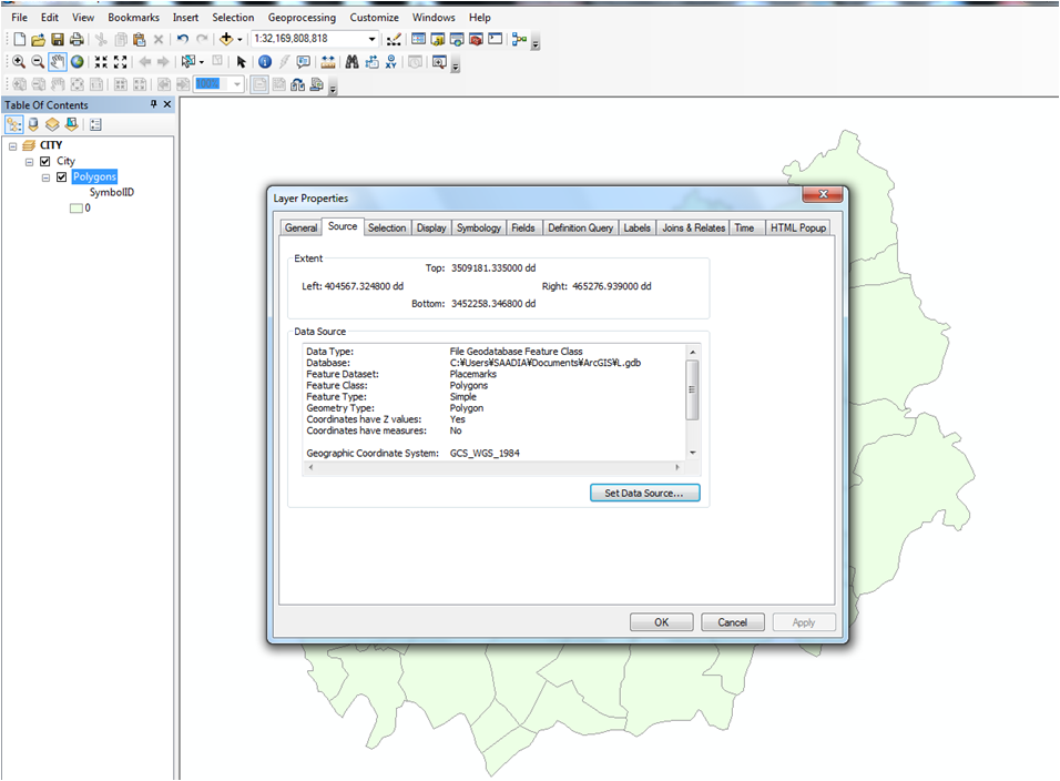
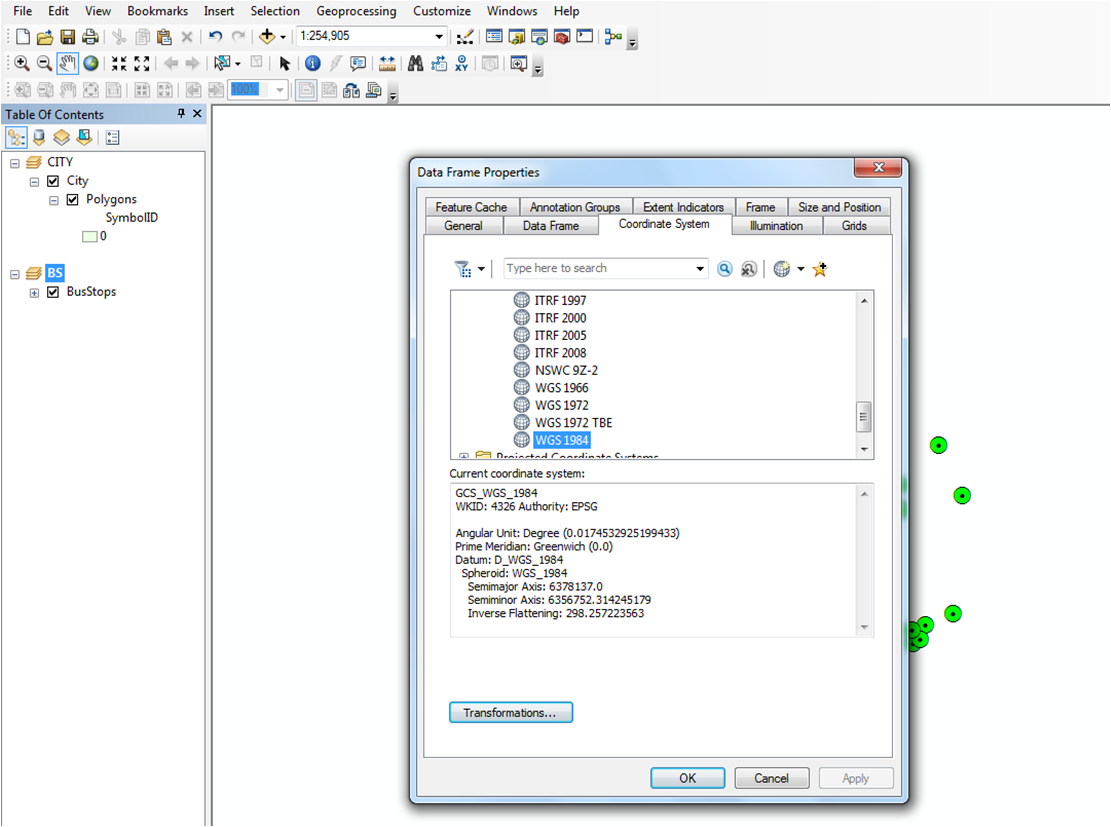
Dan-san Thank you so much for your help. I prepared the separate data frames and found that both the layers have same coordinate systems (as obtained from the same source) , figure1 and 3. But both the layers have different extents, figure2&4. I tried to make the extent same by data frame/properties/ extent/specify extent... but it didn't work. By changing the extent, the layer extent remains the same , it doesn't change.
I have read somewhere that layer extent can not be changed in any way. However i am not sure about it. Anyways i am in view of changing the data source now. Thank you for your kind help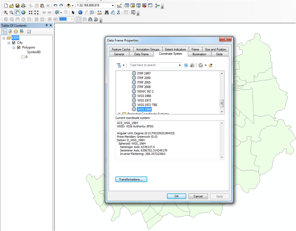

- Mark as New
- Bookmark
- Subscribe
- Mute
- Subscribe to RSS Feed
- Permalink
- Report Inappropriate Content
As I suspected ... your 'numbers' second and fourth image reveal all. Don't look at the 'words' in figures 1 and 3.... In Figure 2, your extent value number indicate that your coordinates are projected. They are NOT in decimal degrees...they are projected. The last one is in decimal degrees. So your 2nd data set seems to be in decimal degrees, most likely GCS_WGS_1984 Your first data set has been defined as such...probably the Define Projection tool was used in error...and it isn't. Fix it...do they look like UTM values for your area? I don't have any reference in your part of the world. In any event, the first file...figures 1 and 2... has been defined incorrectly... they are called Placemarks...Google Earth? Google Maps? Google Google and find out what their coordinate systems are
see projection - EPSG 3857 or 4326 for GoogleMaps, OpenStreetMap and Leaflet - Geographic Information Sy... for instance.
There are a few things that you are mixing up.
- Google Earth is in a Geographic coordinate system with the wgs84 datum. (EPSG: 4326)
- Google Maps is in a projected coordinate system that is based on the wgs84 datum. (EPSG 3857)
- The data in Open Street Map database is stored in a gcs with units decimal degrees & datum of
good luck
- « Previous
-
- 1
- 2
- Next »
- « Previous
-
- 1
- 2
- Next »