- Home
- :
- All Communities
- :
- Products
- :
- Mapping
- :
- Mapping Questions
- :
- Re: Reprojecting to Web Mercator
- Subscribe to RSS Feed
- Mark Topic as New
- Mark Topic as Read
- Float this Topic for Current User
- Bookmark
- Subscribe
- Mute
- Printer Friendly Page
Reprojecting to Web Mercator
- Mark as New
- Bookmark
- Subscribe
- Mute
- Subscribe to RSS Feed
- Permalink
- Report Inappropriate Content
I have the Census TIGER/Line state boundaries, which I am trying to reproject to resemble more commonly held perceptions of state boundaries (i.e. Google maps). The TIGER/Line data is currently projected in:
Projected Coordinate System: Hawaii_Albers_Equal_Area_Conic
Projection: Albers
I am trying to reproject to WGS 1984 Web Mercator (auxiliary sphere), which from my research I understand to be the projection used by Google.
The reprojection tool runs successfully; however, the output looks the same as the input (stretched boundaries as compared to Google maps). I've spent an hour or two researching the best way to accomplish this particular task, but I'm not coming up with answers that have worked.
Advice is much appreciated!
- Mark as New
- Bookmark
- Subscribe
- Mute
- Subscribe to RSS Feed
- Permalink
- Report Inappropriate Content
Thanks. As I mentioned, the reprojection completes successfully. But the shape of the features in the output is the same as the input (even when adding to a new data frame). The details of the input are listed below, if helpful:
Projected Coordinate System: WGS_1984_Web_Mercator_Auxiliary_Sphere
Projection: Mercator_Auxiliary_Sphere
False_Easting: 0.00000000
False_Northing: 0.00000000
Central_Meridian: 0.00000000
Standard_Parallel_1: 0.00000000
Auxiliary_Sphere_Type: 0.00000000
Linear Unit: Meter
Geographic Coordinate System: GCS_WGS_1984
Datum: D_WGS_1984
Prime Meridian: Greenwich
Angular Unit: Degree
I studied projections and coordinates systems in great detail when I was in graduate school, but alas that was many moons ago and I hate to admit I didn't retain all of the knowledge - so I'm struggling to figure out where/ what the issue is.
Thanks for the help.
- Mark as New
- Bookmark
- Subscribe
- Mute
- Subscribe to RSS Feed
- Permalink
- Report Inappropriate Content
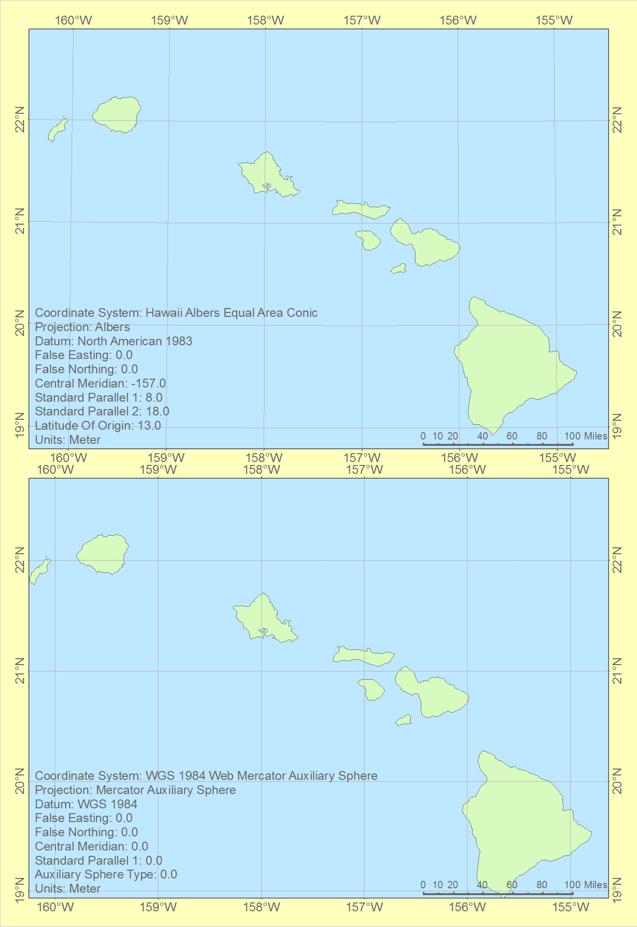
Although it has little relevance to this debate, I thought I would have a look at the 2 projections. Centred on Hawaii, I think that this is where we are talking about.
Both frames are exactly the same scale and are centred on the same point. Note that Web Mercator the scale is smaller. It really is a bad projection to use for almost anywhere!!!!
- Mark as New
- Bookmark
- Subscribe
- Mute
- Subscribe to RSS Feed
- Permalink
- Report Inappropriate Content
Thanks. I don't know why the original data is projected into Hawaii_Albers_Equal_Area_Conic, as the dataset covers the contiguous US (probably some reason why). But, I'm trying to create a US state boundaries dataset that resembles Google maps.
- Mark as New
- Bookmark
- Subscribe
- Mute
- Subscribe to RSS Feed
- Permalink
- Report Inappropriate Content
Well a dataset covering the entire USA would look a little funny using the Hawaii projection (centred on 157degW). Isn't the whole of eastern USA rather distorted?
- Mark as New
- Bookmark
- Subscribe
- Mute
- Subscribe to RSS Feed
- Permalink
- Report Inappropriate Content
I do not know why the original data (as provided by Census TIGER/Line) is projected in the Hawaii Albers projection - that is the original projection - my issue is trying to reproject it to Web Mercator.
- Mark as New
- Bookmark
- Subscribe
- Mute
- Subscribe to RSS Feed
- Permalink
- Report Inappropriate Content
have you checked to see whether you can download the data in another format? You have two non-nationals trying to help with US census data which I am sure someone could step in and solve the problem in a snap. Trying to reproject something that is suitable to something that is barely tolerable is an onerous task.
- Mark as New
- Bookmark
- Subscribe
- Mute
- Subscribe to RSS Feed
- Permalink
- Report Inappropriate Content
I have not been able to find the data I am looking for in the projection I've described. While one may deem it to be an onerous task, 1) I was assigned to find the state boundaries projected as described, and 2) Being that my multiple attempts to reproject the dataset without the desired results, I am now interested in learning why the desired result is not being produced and how I may resolve the issue.
Thanks.
- Mark as New
- Bookmark
- Subscribe
- Mute
- Subscribe to RSS Feed
- Permalink
- Report Inappropriate Content
Your life would be easier if you could get the data in decimal degrees (aka a GCS) and project it directly to the web mercator... that is why I ask.
- Mark as New
- Bookmark
- Subscribe
- Mute
- Subscribe to RSS Feed
- Permalink
- Report Inappropriate Content
Ok, I will try to find the data in a geographic coordinate system. Thanks for the tip.
- Mark as New
- Bookmark
- Subscribe
- Mute
- Subscribe to RSS Feed
- Permalink
- Report Inappropriate Content
Hi David,
Is the location you downloaded the data from public? That is, can you post the location so someone else can try downloading the data?
Also, would you mind sharing the extent of the original data? If you add the data to a new ArcMap and don't change the data frame's coordinate system, what are the extents as you check the edges of the data?
If I add the Esri topographic base map (EPSG:3857), and change the data frame's coordinate system to Hawaii Albers, the extents of the lower 48 are (very roughly!):
x min: 2950000 m
y min: 2060000
x max: 8400000
y max: 5000000

(As far as I know, US census data is almost always in geographic, latitude-longitude).