- Home
- :
- All Communities
- :
- Industries
- :
- Natural Resources
- :
- Mining
- :
- Mining Questions
- :
- Selection halos for ArcPro?
- Subscribe to RSS Feed
- Mark Topic as New
- Mark Topic as Read
- Float this Topic for Current User
- Bookmark
- Subscribe
- Mute
- Printer Friendly Page
Selection halos for ArcPro?
- Mark as New
- Bookmark
- Subscribe
- Mute
- Subscribe to RSS Feed
- Permalink
- Report Inappropriate Content
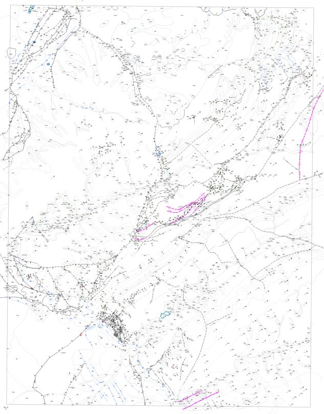
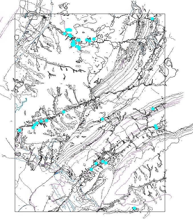
Is there a way to create a selection halo in ArcPro rather than just having the color of the feature change to the selection color? When using the select by attribute feature in ArcPro to select multiple point features that are symbolized as small dots with labels over them, I then press "zoom to" to see where those points are on the map. If the selected points happen to be scattered over a large area, I can't see where the selected points are because the points has just changed color and no selection halo is created. I understand that sometimes the selection halo in ArcMap is annoying because it blocks the view of the actual feature when you zoom in. However, the selection halo is extremely useful when zooming out to smaller scale to see where multiple selected features are within context of your map. The two images are screen captures from ArcMap and ArcPro, both have the exact same data, selected features, symbolization, and same reference scale set. In the ArcPro capture you can't tell where the selected features are. In the the ArcMap capture it's very easy to see where the selected features are. Does anyone know if there is a way to turn on selection halos in ArcPro?
- Mark as New
- Bookmark
- Subscribe
- Mute
- Subscribe to RSS Feed
- Permalink
- Report Inappropriate Content
ArcGIS Pro offers many options to customize feature selection, including how selected features are highlighted in the map. Once you have opened an ArcGIS Pro, navigate to the Project tab and click Options. From here, click on Selection and you will be presented with options to alter the selection configuration. To achieve similar results to those you have specified, I suggest setting the selection colour to R:0 G:255 B:255.
Selection options—ArcGIS Pro | Documentation

Regards,
- Mark as New
- Bookmark
- Subscribe
- Mute
- Subscribe to RSS Feed
- Permalink
- Report Inappropriate Content
I don't think this truly addresses the question - @ZachAnderson2 is asking about the bright CYAN halo that shows in ArcMap when something is selected. The halo makes it much easier to see selected points. The color alone is not enough.
I have changed the selection color in Pro and two things happen. 1. like @ZachAnderson2 i cannot see the points until I zoom way in - and that doesn't help me.
2. in a current project (actually an esri class), the selection color is suddenly PINK even though I have the selection color set to 0/255/255. Please see attached. Using ArcPro 2.8.3, Win10, ESRI earthquake data on 3D map; and ArcMap 10.8
Thank you
- Mark as New
- Bookmark
- Subscribe
- Mute
- Subscribe to RSS Feed
- Permalink
- Report Inappropriate Content
Hi @MatthewBrown8. Thanks for the response but unfortunately your suggestion is not a solution to the problem. As @PegGronemeyer1 says below, changing the color doesn't change the halo effect and the ability to see your selection one bit. The example @PegGronemeyer1 attached and the one I attached to my original post displays the issue very clearly. Try it yourself: Take the same data set of points and throw it into ArcMap and ArcPro. Symbolize those points to be black dots (or any shape of your choosing) under the size of 10. Set both reference scales to 1:24,000. Select a subset of your data in both applications. Zoom out to 1:60,000 (I know this is beyond the reference scale, but it's a very common thing to do if your data cover a large area, or even a USGS 7.5' quadrangle, which is 1:24,000 scale. Point is, don't get hung up on the fact that it's past the reference scale). Now, can you see which points are selected in ArcMap - Yes. Can you see which points are selected in ArcPro - No.
For some reason, the issues isn't as bad with lines and polygons.
- Mark as New
- Bookmark
- Subscribe
- Mute
- Subscribe to RSS Feed
- Permalink
- Report Inappropriate Content
- Mark as New
- Bookmark
- Subscribe
- Mute
- Subscribe to RSS Feed
- Permalink
- Report Inappropriate Content
Dear ESRI,
Selected features, namely points, are way too hard to see in ArcPro compared to ArcGIS. Please promptly fix this, it's extremely annoying.