- Home
- :
- All Communities
- :
- Industries
- :
- Public Safety
- :
- Public Safety Questions
- :
- Move address point from parcel center location to ...
- Subscribe to RSS Feed
- Mark Topic as New
- Mark Topic as Read
- Float this Topic for Current User
- Bookmark
- Subscribe
- Mute
- Printer Friendly Page
Move address point from parcel center location to the center of a smaller polygon within a larger one?
- Mark as New
- Bookmark
- Subscribe
- Mute
- Subscribe to RSS Feed
- Permalink
- Report Inappropriate Content
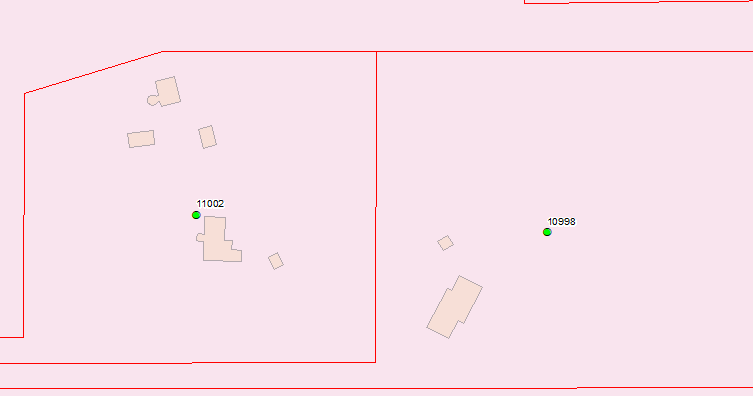
I have a huge area of polygon parcel boundaries and within those parcel boundaries I have smaller polygons for building structures. I also have an address assigned to each parcel but the point is in the center of the parcel polygon.
In the screen capture the red lines are the parcel boundaries and the tan are the building polygon and the green dots are my address points. You can see that I have multiple building polygons in each parcel and I would like the address point moved to the center of the largest building polygon in each parcel. Is this possible? Or do have have to move these one at a time?
- Mark as New
- Bookmark
- Subscribe
- Mute
- Subscribe to RSS Feed
- Permalink
- Report Inappropriate Content
Here's a workflow that probably would work:
1. Do a Spatial Join to add the parcel identification to the buildings layer.
Spatial Join—Help | ArcGIS Desktop
2. Use the shape.area field (or whatever area field is in the database you are using) to find the largest building in each parcel. Save these features as a separate feature class. (There's probably an automated way to find the largest building polygon for each similar parcel ID when there are multiple buildings, but at the moment that process is eluding me)
3. Run Feature to Point with the Point Location (optional) setting set to Centroid on the largest buildings found in step 2. Run the tool again with the the Inside option to see if that works better for your data.
Feature To Point—Data Management toolbox | ArcGIS Desktop
4. Make a copy of the parcel address point feature class. Run Snap on the copy of the parcel address point features (not the original, as this tool will permanently modify the features).
Chris Donohue, GISP
- Mark as New
- Bookmark
- Subscribe
- Mute
- Subscribe to RSS Feed
- Permalink
- Report Inappropriate Content
Chris, I like this workflow but it's good to point out that Feature to Point is only with an Advanced License and Snap is only with a Standard or Advanced License.
For a Feature to Point work around, you could potentially do this:
1. Add Geometry Attributes—Help | ArcGIS for Desktop
to get internal XY
2. Create Table—Help | ArcGIS for Desktop
to spit out a table with all the attributes of your polygon including XY attributes
3. Adding x,y coordinate data as a layer—Help | ArcGIS for Desktop
make an event layer with your new XY table - to make points
4. Export the data to a new feature class.