- Home
- :
- All Communities
- :
- Industries
- :
- Public Safety
- :
- Public Safety Questions
- :
- Re: Topology AddIn Guinea Pig wanted
- Subscribe to RSS Feed
- Mark Topic as New
- Mark Topic as Read
- Float this Topic for Current User
- Bookmark
- Subscribe
- Mute
- Printer Friendly Page
Topology AddIn Guinea Pig wanted
- Mark as New
- Bookmark
- Subscribe
- Mute
- Subscribe to RSS Feed
- Permalink
- Report Inappropriate Content
Hey everybody,
On a monthly basis I create a bunch of topologys to make sure that my polygon layers don't overlap or have gaps (ESN). I also run a topology on my street layer to find street segments that aren't snapped. This process consists mostly of models.
Since I always try to help my Public safety brethren, I figured I compile my process in a Python AddIn, that "should be easy to use". I started a day ago and have the skeleton of the AddIn finished and now I am looking for a Guinea Pig (I am looking at you Chris Donohue, GISP & Joe Borgione ) to use it!
Latest Update:
- Created an official document: Topology Check Python AddIn (6/30/17)
- Added Error message when the wrong feature is chosen for certain Checks (i.e. polygon feature is chosen for dangle check)
- Now works with ArcGIS Desktop Standard
- Latest test version that includes a polygon break check. This check make sure that your line features are broken when they intersect with a polygon feature. Just select the line feature and polygon feature in the TOC and run the check.
Dropbox - TopoAddIn.esriaddin 10.3.1 + version
Here is what you need:
ArcGIS Desktop Standard 10.3.1 or later versions
Here is how it works:
1. You would download the add in HERE. (10.1 version HERE )
2. Double click it and install it.
3. Open an MXD and add a polygon layer and a street layer.
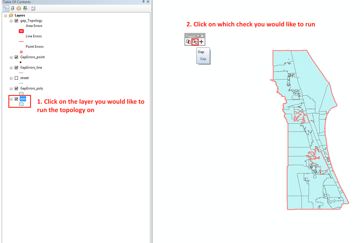
4.The toolbar should be there but if it is not click on Customize -> Toolbars -> TopoCheck
5. Follow the steps in the screenshot!
As I said it is still a work in progress, especially the street dangle check.
Let me know what you think!
Tim
- Mark as New
- Bookmark
- Subscribe
- Mute
- Subscribe to RSS Feed
- Permalink
- Report Inappropriate Content
Since it seems to be in a stable condition, I might create a document instead of using the guinea pig thread.
- Mark as New
- Bookmark
- Subscribe
- Mute
- Subscribe to RSS Feed
- Permalink
- Report Inappropriate Content
Fun fact jborgion , apparently you can use the select tool and select a couple of streets and then run the dangle tool on just those streets (you still need to select the street layer in your table of contents).
- Mark as New
- Bookmark
- Subscribe
- Mute
- Subscribe to RSS Feed
- Permalink
- Report Inappropriate Content
That's cool Tim; just tried it. Before running the tool I created the dangle that was subsequently found. It's the only one in the YourDangleErrors point feature class:

This is great feature for me; I can run it just on streets that are newly added and get them fixed asap. Thanks!
ETA: here is a perfect example. Notice the M_DATE value (modified date) of the street that has the dangle...

- Mark as New
- Bookmark
- Subscribe
- Mute
- Subscribe to RSS Feed
- Permalink
- Report Inappropriate Content
That just reminds me how I hate creating or modifying streets!
- Mark as New
- Bookmark
- Subscribe
- Mute
- Subscribe to RSS Feed
- Permalink
- Report Inappropriate Content
- Mark as New
- Bookmark
- Subscribe
- Mute
- Subscribe to RSS Feed
- Permalink
- Report Inappropriate Content
timw1984 I would like to demo this tool to my integration group in a couple of weeks. Do you mind?
- Mark as New
- Bookmark
- Subscribe
- Mute
- Subscribe to RSS Feed
- Permalink
- Report Inappropriate Content
Go ahead Heather and let me know how it went! I have created a document with the latest download here https://community.esri.com/docs/DOC-9983-topology-check-python-addin This download also includes a readme file, which has pretty pictures and explanations 
- Mark as New
- Bookmark
- Subscribe
- Mute
- Subscribe to RSS Feed
- Permalink
- Report Inappropriate Content
Great! Will do. One suggestion on the documentation is to add in your assumptions - like the 15 ft distance for dangles if that's what it is. I like your idea of adding a user-defined distance in a future version!
- Mark as New
- Bookmark
- Subscribe
- Mute
- Subscribe to RSS Feed
- Permalink
- Report Inappropriate Content
- Mark as New
- Bookmark
- Subscribe
- Mute
- Subscribe to RSS Feed
- Permalink
- Report Inappropriate Content
Anyone test this with 10.5?