- Home
- :
- All Communities
- :
- Developers
- :
- Python
- :
- Python Questions
- :
- Get parameter as text
- Subscribe to RSS Feed
- Mark Topic as New
- Mark Topic as Read
- Float this Topic for Current User
- Bookmark
- Subscribe
- Mute
- Printer Friendly Page
- Mark as New
- Bookmark
- Subscribe
- Mute
- Subscribe to RSS Feed
- Permalink
- Report Inappropriate Content
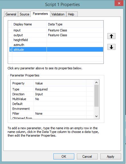
I have 5 parameters in my arcpy script, imported into a toolbox.
inputFC = arcpy.GetParameterAsText(0)
outputFC = arcpy.GetParameterAsText(1)
heightfield = arcpy.GetParameterAsText(2) #Must be in the same units as the coordinate system!
azimuth = math.radians(float(arcpy.GetParameterAsText(3))) #Must be in degrees
altitude = math.radians(float(arcpy.GetParameterAsText(4))) #Must be in degrees
I have building footprints, including height in the attribute, and I want to compute the shadow of the building in 2D.
Could anyone tell me which 'Data type' and parameter properties I should define before running the script? Thanks
Solved! Go to Solution.
Accepted Solutions
- Mark as New
- Bookmark
- Subscribe
- Mute
- Subscribe to RSS Feed
- Permalink
- Report Inappropriate Content
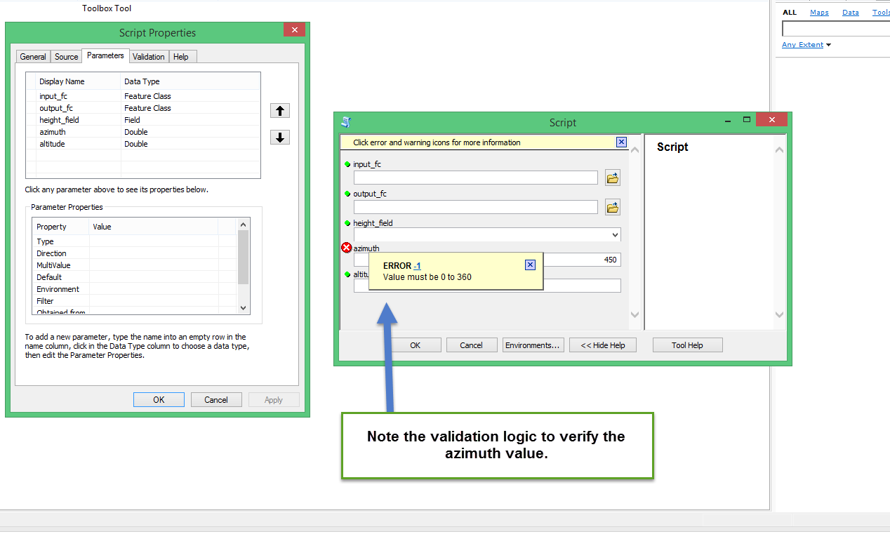
Is there a reason why you're specifying the Azimuth and Altitude values as Any Value and not Double? The Any Value type would allow you to insert alphanumeric text and I'd assume you'd need to add logic into your code to account for this. For example, Any Value would allow you to provide values like 90° or EAST or 90.0, whereas Double would restrict you to 90.0. You could also use validation logic to verify that your azimuth or altitude values are within the expected ranges. I've included a quick example of the logic below.
import arcpy
class ToolValidator(object):
"""Class for validating a tool's parameter values and controlling
the behavior of the tool's dialog."""
def __init__(self):
"""Setup arcpy and the list of tool parameters."""
self.params = arcpy.GetParameterInfo()
def initializeParameters(self):
"""Refine the properties of a tool's parameters. This method is
called when the tool is opened."""
return
def updateParameters(self):
"""Modify the values and properties of parameters before internal
validation is performed. This method is called whenever a parameter
has been changed."""
return
def updateMessages(self):
"""Modify the messages created by internal validation for each tool
parameter. This method is called after internal validation."""
if self.params[3].value < 0.0 or self.params[3].value > 360.0:
self.params[3].setErrorMessage("Value must be 0 to 360")
else:
self.params[3].clearMessage()
return
- Mark as New
- Bookmark
- Subscribe
- Mute
- Subscribe to RSS Feed
- Permalink
- Report Inappropriate Content
The numbers (Height) etc could be added as any value
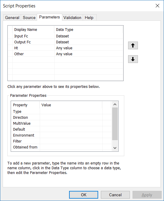
Also see here :
- Mark as New
- Bookmark
- Subscribe
- Mute
- Subscribe to RSS Feed
- Permalink
- Report Inappropriate Content
The height value is not a constant value through the whole building shapefile. It varies from one polygon to another. Its the same data you have commented on the other question of mine: HERE is there a 'data type' where it can import the value of a column of attribute (building height). And I have tried it with the following parameters:

I've typed 'Building_H' at the height field, but then ended up with:
- Mark as New
- Bookmark
- Subscribe
- Mute
- Subscribe to RSS Feed
- Permalink
- Report Inappropriate Content
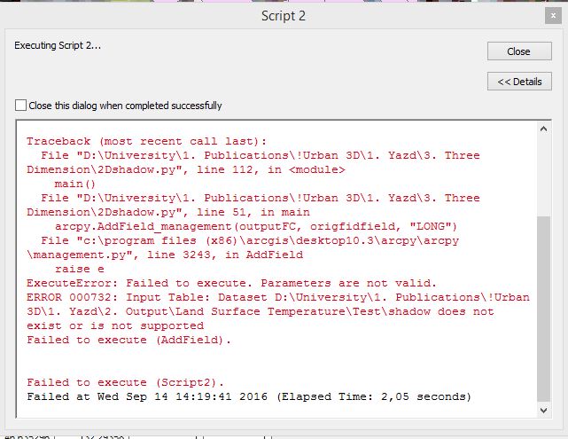
I think the code may be failing on this section:
    # Create in-memory feature class for holding the shadow polygons
    tempshadows = r"in_memory\tempshadows"
    arcpy.CreateFeatureclass_management(
        "in_memory",
        "tempshadows",
        "POLYGON", "", "", "",
        outputSR)
    arcpy.AddField_management(tempshadows, origfidfield, "LONG")
The syntax for the Create Feature Class tool is:
CreateFeatureclass_management (out_path, out_name, {geometry_type}, {template}, {has_m}, {has_z}, {spatial_reference}, {config_keyword}, {spatial_grid_1}, {spatial_grid_2}, {spatial_grid_3})

It looks like you are creating a feature class called in_memory\in_memory\tempshadows - and I think one of the in_memory's needs to be removed.
- Mark as New
- Bookmark
- Subscribe
- Mute
- Subscribe to RSS Feed
- Permalink
- Report Inappropriate Content
I agree with Neil. The "Any Value" option would work well.
In addition to this, if your heightfield parameter should have a field as the input, you can use "Field" for the data type. You can then loop through the values in the field within the script.
If you want to validate that the input values for heightfield, azumuth, and altitude are in the correct data type (ex; degrees) you can add some code to validate the values. Ex; loop through all azimuth values to ensure they are of the float data type and all between 0 and 360 - this would be done within the script after the parameters have been set, but before the rest of the script executes. Then just spit out a message to the user if the data is not in the correct format.
- Mark as New
- Bookmark
- Subscribe
- Mute
- Subscribe to RSS Feed
- Permalink
- Report Inappropriate Content
Is there a reason why you're specifying the Azimuth and Altitude values as Any Value and not Double? The Any Value type would allow you to insert alphanumeric text and I'd assume you'd need to add logic into your code to account for this. For example, Any Value would allow you to provide values like 90° or EAST or 90.0, whereas Double would restrict you to 90.0. You could also use validation logic to verify that your azimuth or altitude values are within the expected ranges. I've included a quick example of the logic below.
import arcpy
class ToolValidator(object):
"""Class for validating a tool's parameter values and controlling
the behavior of the tool's dialog."""
def __init__(self):
"""Setup arcpy and the list of tool parameters."""
self.params = arcpy.GetParameterInfo()
def initializeParameters(self):
"""Refine the properties of a tool's parameters. This method is
called when the tool is opened."""
return
def updateParameters(self):
"""Modify the values and properties of parameters before internal
validation is performed. This method is called whenever a parameter
has been changed."""
return
def updateMessages(self):
"""Modify the messages created by internal validation for each tool
parameter. This method is called after internal validation."""
if self.params[3].value < 0.0 or self.params[3].value > 360.0:
self.params[3].setErrorMessage("Value must be 0 to 360")
else:
self.params[3].clearMessage()
return
- Mark as New
- Bookmark
- Subscribe
- Mute
- Subscribe to RSS Feed
- Permalink
- Report Inappropriate Content
Thanks, It worked finally perfect!