- Home
- :
- All Communities
- :
- Developers
- :
- Python
- :
- Python Questions
- :
- Not sure how to fix an Index Error
- Subscribe to RSS Feed
- Mark Topic as New
- Mark Topic as Read
- Float this Topic for Current User
- Bookmark
- Subscribe
- Mute
- Printer Friendly Page
Not sure how to fix an Index Error
- Mark as New
- Bookmark
- Subscribe
- Mute
- Subscribe to RSS Feed
- Permalink
- Report Inappropriate Content
I am working on updating a python script that was created in python 2.6 for ArcGIS 10.0.
We are now working with python 2.7.8 in ArcGIS 10.3
I did not write the script and am still a little fuzzy on exactly what its doing (which is probably why I need help figuring out this error).
The script is performing a Moore Neighborhood analysis on an array where it's walking through each cell in the DEM raster and comparing that cell value to the 8 surrounding cells, it extracts a minimum value from those 8 cells and then inserts that value into a corresponding constant array.
The script runs through the first 3 if statements ok, but then gets to the 4th one and throws the error:
Traceback (most recent call last):
File "S:\Rachel\Projects\Storm_Sewer\Python\Surface_Flow.py", line 51, in <module>
if myArray
IndexError: index 3510 is out of bounds for axis 0 with size 3510
Presumably, the script is calculating something outside a a predefined range but I'm not sure what that is and/or how to fix it so that the script still returns the correct values.
Both the original DEM and constant raster's were floating values before turning them into arrays. Not sure if that's relevant.
SCRIPT:
#Global Variables: t=numpy.empty((49,1)) c=0 #Turn DEM into an array matrix. myArray = arcpy.RasterToNumPyArray(DEM) constant2 = arcpy.RasterToNumPyArray(constant) #Moore Neighborhood Analysis #Neighboorhood Analysis will walk through each cell comparing all surrounding #cells, extract minimum values, and insert them into the constant raster location for u in range(len(myArray)-1): for v in range(len(myArray)-1): if myArray>myArray[u-1] constant2[u-1]: =myArray[u-1] if myArray>myArray[u+1] constant2[u+1]: =myArray[u+1] if myArray>myArray[u-1][v-1]: constant2[u-1][v-1]=myArray[u-1][v-1] if myArray>myArray[u-1][v+1]: constant2[u-1][v+1]=myArray[u-1][v+1] if myArray[u+1][v+1]>myArray[u+1][v+1]: constant2 [u+1][v+1]=myArray[u+1][v+1] if myArray>myArray[u+1][v-1]: constant2 [u+1][v-1]=myArray[u+1][v-1] if myArray>myArray[v+1]: constant2[v+1]=myArray[v+1] if myArray[v-1]>myArray[v-1]: constant2[v-1]=myArray[v-1]
- Mark as New
- Bookmark
- Subscribe
- Mute
- Subscribe to RSS Feed
- Permalink
- Report Inappropriate Content
There seems to be some inconsistency in you code :
for u in range(len(myArray)-1):
- for v in range(len(myArray)-1):
- if myArray
>myArray[u-1] : - constant2[u-1]
=myArray[u-1] - if myArray
>myArray[u+1] : - constant2[u+1]
=myArray[u+1] - if myArray
>myArray[u-1][v-1]: - constant2[u-1][v-1]=myArray[u-1][v-1]
- if myArray
>myArray[u-1][v+1]: - constant2[u-1][v+1]=myArray[u-1][v+1]
- if myArray[u+1][v+1]>myArray[u+1][v+1]:
- constant2 [u+1][v+1]=myArray[u+1][v+1]
- if myArray
>myArray[u+1][v-1]: - constant2 [u+1][v-1]=myArray[u+1][v-1]
- if myArray
>myArray[v+1]: - constant2[v+1]=myArray[v+1]
- if myArray[v-1]>myArray[v-1]:
- constant2[v-1]=myArray[v-1]
Gee that's looks terrible on my side.
All the "ifs" are comparing myArray(,v]) with the cells around it. Except at lines 11 & 17 (I think)
Why is that?
- Mark as New
- Bookmark
- Subscribe
- Mute
- Subscribe to RSS Feed
- Permalink
- Report Inappropriate Content
Then, why not just run a raster filter for Min on the original raster with a 3X3 processing window?
- Mark as New
- Bookmark
- Subscribe
- Mute
- Subscribe to RSS Feed
- Permalink
- Report Inappropriate Content
The route makes a lot more sense. I ran the tool, but the output was exactly the same as the input. I find that odd, don't you?
- Mark as New
- Bookmark
- Subscribe
- Mute
- Subscribe to RSS Feed
- Permalink
- Report Inappropriate Content
You ran this tool on your data...
This is in SA Tools / Neighbourhood /
The result cannot be the same...
- Mark as New
- Bookmark
- Subscribe
- Mute
- Subscribe to RSS Feed
- Permalink
- Report Inappropriate Content
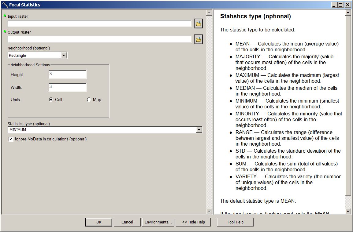
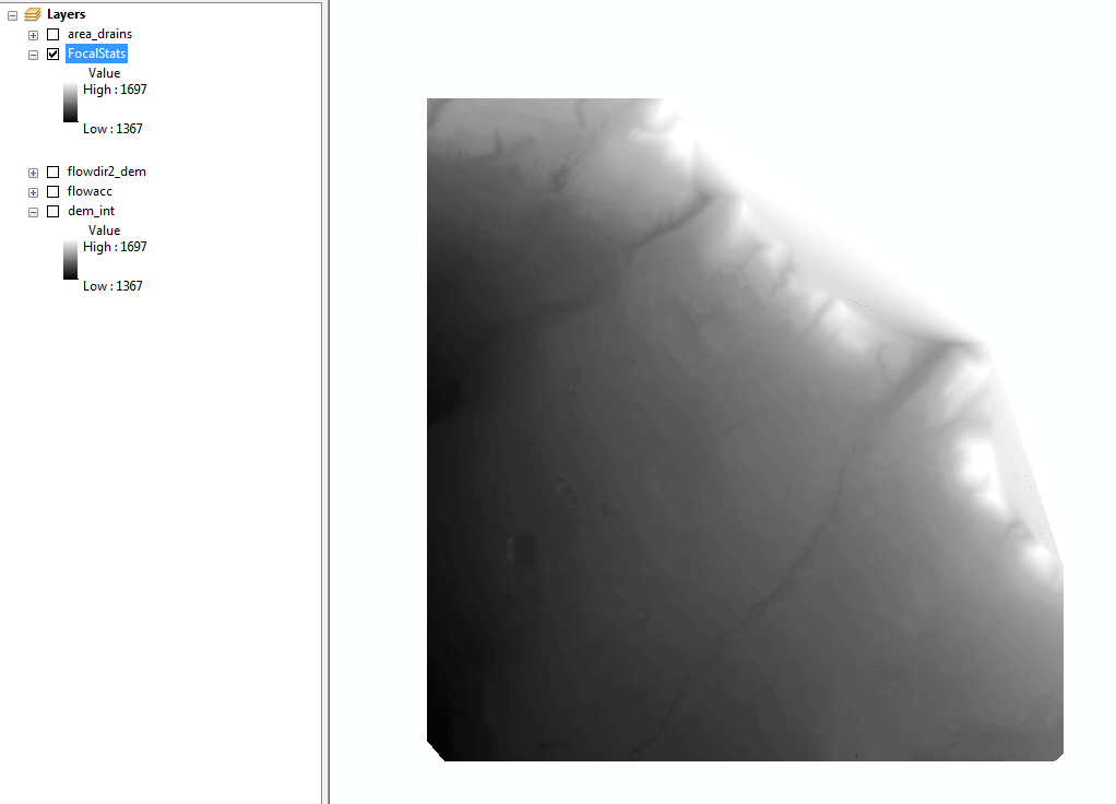
That's exactly what I ran and the results came out exactly like my DEM - somethings wrong and I'm not sure what. DEM being used as input (notes high and low values):

Focal Stats Window:

Results (Note image and high/low values are exactly the same as the DEM)

- Mark as New
- Bookmark
- Subscribe
- Mute
- Subscribe to RSS Feed
- Permalink
- Report Inappropriate Content
Just because the min/max values in the TOC are the same, the internal values (ie the distribution) should / have to be a bit different.
But this is getting a little off the original topic.
- Mark as New
- Bookmark
- Subscribe
- Mute
- Subscribe to RSS Feed
- Permalink
- Report Inappropriate Content
I'm OK with getting a little off topic if the topic leads me to produce the results I need. Thank you
- Mark as New
- Bookmark
- Subscribe
- Mute
- Subscribe to RSS Feed
- Permalink
- Report Inappropriate Content
I don't suppose you can tell me what the shape and number of dimensions the input and constant raster have? And perhaps you can elaborate on what t=numpy.empty((49,1)) is supposed to be...is that the destination array? (which will only hold 49 rows and 1 column of data. What is constant? c? are there lines of code missing? Could you provide the un-updated script that you know worked?
- Mark as New
- Bookmark
- Subscribe
- Mute
- Subscribe to RSS Feed
- Permalink
- Report Inappropriate Content
Both the original input DEM & constant rasters are 3510 (columns) and 3645 (rows)
I'm still trying figure out what the Global variables are there for as well. I commented them out to see if it would make a difference and I still got the same error.