- Home
- :
- All Communities
- :
- Industries
- :
- Natural Resources
- :
- Renewable Energy
- :
- Renewable Energy Questions
- :
- Re: Solar map / Solarkataster
- Subscribe to RSS Feed
- Mark Topic as New
- Mark Topic as Read
- Float this Topic for Current User
- Bookmark
- Subscribe
- Mute
- Printer Friendly Page
Solar map / Solarkataster
- Mark as New
- Bookmark
- Subscribe
- Mute
- Subscribe to RSS Feed
- Permalink
- Report Inappropriate Content
Hello dear community,
I have a question about a production of a solar map / land register. The basis are 2D- and 3D- digitizations of buildings as polygons. Does anyone have an idea or workflow on how to do this efficiently?
Thank you very much.
Christian
Hallo liebe Community,
ich habe eine Frage zur Erstellung eines Solarkatasters. Als Grundlage sollen 2D- und 3D-Auswertungen von Gebäuden als Polygone dienen. Hat jemand eine Idee oder einen Workflow, wie man das effizient vollbringen kann?
Ich freue mich jetzt schon auf hilfreiche Antworten.
Beste Grüße
Christian
- Mark as New
- Bookmark
- Subscribe
- Mute
- Subscribe to RSS Feed
- Permalink
- Report Inappropriate Content
Hi Christian Lehmann , in case you want to obtain the potential solar energy for each rooftop in an defined area, you will need information of the height of the buildings and type of roof. Best would be to have a Digital Surface Model (DSM) which could be obtained using Drones (see: Drone2Map for ArcGIS - Turn Your Drone Into an Enterprise GIS Productivity Tool | Esri ).
The DSM is the most important input when using the tool Area Solar Radiation—Help | ArcGIS Desktop , which will take the DSM and the central lat lon coordinate to model the sun during for instance several representative days during a days and several moments during those days to model and combine the direct, reflected and diffuse radiation:
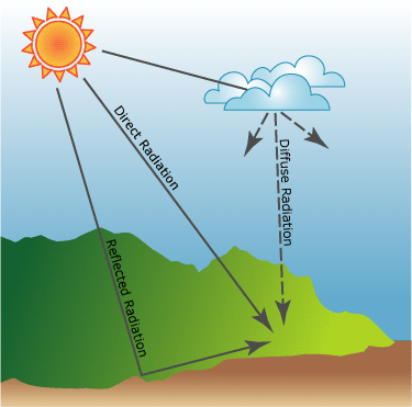
source: Modeling solar radiation—Help | ArcGIS Desktop
The result will be a raster that will contain the potential solar energy for the modeled time range for each pixel, taking into account any shades that larger building might cause on surrounding building. You can link this data to the building polygons by using the Zonal Statistics as Table—Help | ArcGIS Desktop to create a table that contains per building polygon ID statistics about the solar radiation. This can be linked back to the buildings for further processing.
I posted a document on using drones to generate the DSM, calculate solar radiation, link that to the building rooftops and generate solar panel configurations. It is in Spanish, but might be interesting to scroll through: Generación de Paneles Solares en techos Bogotá
- Mark as New
- Bookmark
- Subscribe
- Mute
- Subscribe to RSS Feed
- Permalink
- Report Inappropriate Content
Hi Xander Bakker,
Thanks for your answer!
Kind regards
Christian