- Home
- :
- All Communities
- :
- Industries
- :
- Transportation
- :
- Roads and Highways
- :
- Roads and Highways Questions
- :
- Overpass and Underpass detection for intersections...
- Subscribe to RSS Feed
- Mark Topic as New
- Mark Topic as Read
- Float this Topic for Current User
- Bookmark
- Subscribe
- Mute
- Printer Friendly Page
Overpass and Underpass detection for intersections layer
- Mark as New
- Bookmark
- Subscribe
- Mute
- Subscribe to RSS Feed
- Permalink
- Report Inappropriate Content
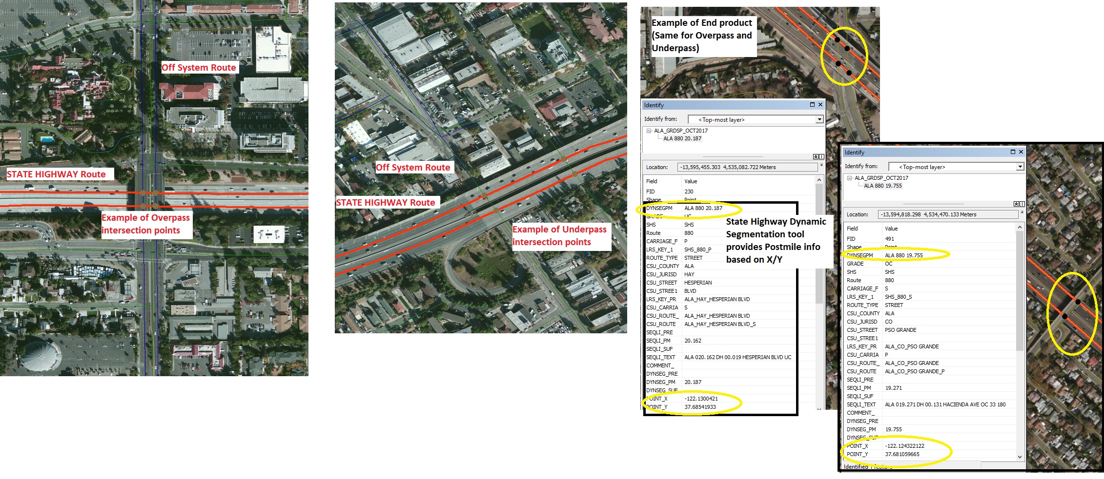
I have a highways layer and a non state routes layer (roads) that I am using to create an intersection points layer. I am then putting the points layer on top of Google Earth and manually identifying highway overpasses and underpasses,
I would like to think there is a way to automate this or are there functions in ArcGIS that relate to it?
Will send screenshots upon request.
- Mark as New
- Bookmark
- Subscribe
- Mute
- Subscribe to RSS Feed
- Permalink
- Report Inappropriate Content
Create Overpass—ArcGIS Pro | ArcGIS Desktop and
Create Underpass—ArcGIS Pro | ArcGIS Desktop
But that would be too easy … and how do you differentiate between over and under (depends on direction I suppose)
are you running into situations where the linework shows an intersection point but it is actually an overpass?
- Mark as New
- Bookmark
- Subscribe
- Mute
- Subscribe to RSS Feed
- Permalink
- Report Inappropriate Content
Dan:
See attached for what I am trying to do.
Yes, your last point is correct (same also goes for Underpass).
1. I don’t have ArcGIS Pro at work although I could get it at home.
2. Direction DOES NOT matter.
3. I have seen the links that you are talking about with Pro but how would they automatically detect Overpass and Underpass?
It might be on our end that we need to upgrade our Postmile Validation Wizard tool to integrate intersection types into it but I cannot speak to whether or not updates will happen soon.
Daniel T. Brenner
RESEARCH ANALYST I (GEOGRAPHIC INFORMATION SYSTEMS)
DIVISION OF RESEARCH, INNOVATION, and SYSTEM INFORMATION
Highway System Information and Performance
1120 N Street MS 38
Sacramento, CA 95814
(916) 657-4277
(510) 593-7547 cell
daniel.brenner@dot.ca.gov<mailto:daniel.brenner@dot.ca.gov>
“Consider the unconsidered.”
“Certainty is not a sure thing!”
- Mark as New
- Bookmark
- Subscribe
- Mute
- Subscribe to RSS Feed
- Permalink
- Report Inappropriate Content
Daniel, those tools won't automatically detect... that's why I said it would be too easy.
I don't know what, if any, logical consistency is used when creating a road network. my first inclination would not to allow an intersection point where lines cross if it is an overpass or underpass. That would separate crossing lines from true intersections.
You seem to be better placed to see if anyone has come up with an automated process
- Mark as New
- Bookmark
- Subscribe
- Mute
- Subscribe to RSS Feed
- Permalink
- Report Inappropriate Content
If other types of features like bridges can be extracted from Google Earth, why couldn’t Overpasses and Underpasses be identified? Or do I have to use another type of imagery to do extraction?
I could be wrong but wouldn’t I also have a sense I’d need to use a Z factor since I’m working with a three dimensional scenario?
Daniel T. Brenner
RESEARCH ANALYST I (GEOGRAPHIC INFORMATION SYSTEMS)
DIVISION OF RESEARCH, INNOVATION, and SYSTEM INFORMATION
Highway System Information and Performance
1120 N Street MS 38
Sacramento, CA 95814
(916) 657-4277
(510) 593-7547 cell
daniel.brenner@dot.ca.gov<mailto:daniel.brenner@dot.ca.gov>
“Consider the unconsidered.”
“Certainty is not a sure thing!”
- Mark as New
- Bookmark
- Subscribe
- Mute
- Subscribe to RSS Feed
- Permalink
- Report Inappropriate Content
I work within Transportation... There is no magical way of detecting Underpasses or Overpasses that are reliable. Old fashion elbow grease is the only sure way. Within the attributes, I generally have a field call OverUnder and I manually populate that field. Values I use: 1 for Overpass, 2 for Underpass and Null/0 for plain old road.
Some techniques I use for finding Overpasses..... They occur at Intersection and generally have a Bridge associated with them. So I query the map for all Intersection points that are within a small buffer range of a Bridge (Polygon layer in my case). This leaves a mucher set of points that I need to determine Over or Under codes manually!
- Mark as New
- Bookmark
- Subscribe
- Mute
- Subscribe to RSS Feed
- Permalink
- Report Inappropriate Content
Ted,
I will go to my corner now and let my GIS career rot on the vine...
The first part is essentially what I have for the Overpass/Underpass classification. The situation I have is not about bridges and selecting points within a buffer isn’t relevant either because I am working with an Intersection Points layer based highway Postmiles created by a Dynamic Segmentation application using the California State Highway System. I do manual identification once I have the Points layer created based on Postmiles.
I don’t have Roads and Highways yet, and you would think the tools in ArcGIS Pro would be able to detect and classify types of intersections but essentially they are high end graphics tools and not related to the spatial data (i.e., Lat/Long point location).
If Bridges and other features can be extracted from imagery, why isn’t there a way to do feature extraction from Google Earth? Or can I only use another type of imagery?
Daniel T. Brenner
RESEARCH ANALYST I (GEOGRAPHIC INFORMATION SYSTEMS)
DIVISION OF RESEARCH, INNOVATION, and SYSTEM INFORMATION
Highway System Information and Performance
1120 N Street MS 38
Sacramento, CA 95814
(916) 657-4277
(510) 593-7547 cell
daniel.brenner@dot.ca.gov<mailto:daniel.brenner@dot.ca.gov>
“Consider the unconsidered.”
“Certainty is not a sure thing!”
- Mark as New
- Bookmark
- Subscribe
- Mute
- Subscribe to RSS Feed
- Permalink
- Report Inappropriate Content
Digital Recognition????
I had a company try this using Lidar in one of our projects.... (failure) We ended up doing it by hand because the reliability was so bad that the false positives were more work than coding by hand. Even Bridge extraction that I have had party to were horribly bad... missed Bridge Culverts, mis-identified sign structures, utility lines etc as Bridges and simply missed classical Bridge structures.
Some articles in reference to extracting Overpasses that I found and may be of assistance:
https://static.googleusercontent.com/media/research.google.com/en//pubs/archive/37364.pdf
https://dl.acm.org/citation.cfm?id=2093975
Yes I am an old fart!
No need to rot away in the corner there is no progress without bumps along the way!
- Mark as New
- Bookmark
- Subscribe
- Mute
- Subscribe to RSS Feed
- Permalink
- Report Inappropriate Content
I have heard the term is Feature Extraction…
Thanks for this too, Ted, this is very useful, although I would have thought it wouldn’t be that hard to do?
But I will say that I have done some research and I have seen how other State DOTs or larger jurisdictions have done Multi Grade intersection layers with postmiles that may be similar to what I want but I just thought I’d try ESRI’s Forums first.
Will check out the articles soon.
Daniel Brenner