- Home
- :
- All Communities
- :
- Products
- :
- Spatial Data Science
- :
- Spatial Data Science Questions
- :
- Re: calculation and mapping Albedo
- Subscribe to RSS Feed
- Mark Topic as New
- Mark Topic as Read
- Float this Topic for Current User
- Bookmark
- Subscribe
- Mute
- Printer Friendly Page
- Mark as New
- Bookmark
- Subscribe
- Mute
- Subscribe to RSS Feed
- Permalink
- Report Inappropriate Content
Can anybody here gives me some suggestions as to the best way to calculate and map Albedo effect. Those of you don't know what it is, Albedo specifies the percentage of incoming solar radiation on a surface that reflects back. I need help. Thanks, folks.
Solved! Go to Solution.
Accepted Solutions
- Mark as New
- Bookmark
- Subscribe
- Mute
- Subscribe to RSS Feed
- Permalink
- Report Inappropriate Content
Albedo is determined from measurement...as per you definition... and it can be used with respect to particular wavelengths or wave bands.. Generic values can be obtained from climatology texts etc.
- Is your desire to ascribe albedo values to land surfaces?
- are you referring to shortwave (within visible range) or longwave/infrared albedo?
- are you interested in albedo at particular wavelengths?
- what type of surfaces are you interested in?
- do you just want average albedo or are you interested in values that may vary by time of day or surface roughness?
Just some thoughts.
- Mark as New
- Bookmark
- Subscribe
- Mute
- Subscribe to RSS Feed
- Permalink
- Report Inappropriate Content
Thanks Dan. Yes my desire is to ascribe albedo values to mountain surface where there are snow stability in most part of the year making sunlight reflection possibly high. I was thinking in generic terms to find out the part of the mountain that faces the sun most. I hope you get my point.
- Mark as New
- Bookmark
- Subscribe
- Mute
- Subscribe to RSS Feed
- Permalink
- Report Inappropriate Content
Then you need the Aspect tool in the Spatial Analyst or 3D analyst extension or aspect function
http://desktop.arcgis.com/en/desktop/latest/tools/spatial-analyst-toolbox/aspect.htm
http://desktop.arcgis.com/en/desktop/latest/manage-data/raster-and-images/aspect-function.htm
You should also have a look at...
- Mark as New
- Bookmark
- Subscribe
- Mute
- Subscribe to RSS Feed
- Permalink
- Report Inappropriate Content
I really apreciate your suggestions. Both aproaches seem so interesting. For now I don't have the extention tool for Spatial Analysyst or 3 D analyst and the Radiation tool analyst but I have requested for one. Please do you think only the historical mountainous snow raster data and their associate statistics are enough?
- Mark as New
- Bookmark
- Subscribe
- Mute
- Subscribe to RSS Feed
- Permalink
- Report Inappropriate Content
If that is what you have, it is definitely a starting part, particularly if you can show that the historical data is consistent.
- Mark as New
- Bookmark
- Subscribe
- Mute
- Subscribe to RSS Feed
- Permalink
- Report Inappropriate Content
Hi again, Dan,
Sorry for the nagging. Still on my Albedo stuff. I now have my Solar Radiation calculated, Aspect
image, and Snow dataset. Please any suggestion as to the way forward?
- Mark as New
- Bookmark
- Subscribe
- Mute
- Subscribe to RSS Feed
- Permalink
- Report Inappropriate Content
You will have to come up with your classification scheme since aspect are floating point numbers. You can use the reclassify tool amongst others and class the slopes and aspects to appropriate classes along with your snow dataset (ie deep, shallow etc) and use the combine tool to delineat areas that meet certain criteria (ie N facing shallow slopes have the deepest snow...or whatever you are interested in)
- Mark as New
- Bookmark
- Subscribe
- Mute
- Subscribe to RSS Feed
- Permalink
- Report Inappropriate Content
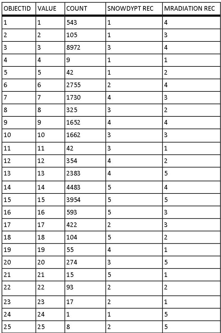
Hi again, Dan.
The Reclassification and the Combine tool is working well and giving me some
interesting tables. The only problem is that I'm trying to make sense of the
values from different combination and tables to get some Albedo values. I am
attaching a sample of the combination of Snowdata and Radiation for some
suggestions.
- Mark as New
- Bookmark
- Subscribe
- Mute
- Subscribe to RSS Feed
- Permalink
- Report Inappropriate Content
the first class (value 1) ... there are 543 cells that are the combination of snowdtptrec and mradiationrec (whatever those) represent. etc etc
some times it is better to make a table out of them like a pivot table
snow typ class
rad cla 1 2 3 4 5
1
2 8 (your last class)
3
4 543 (your first)
fill in the matrix