- Home
- :
- All Communities
- :
- Industries
- :
- State & Local Government
- :
- State & Local Government Questions
- :
- Do you clip your parcels to the road right-of-way ...
- Subscribe to RSS Feed
- Mark Topic as New
- Mark Topic as Read
- Float this Topic for Current User
- Bookmark
- Subscribe
- Mute
- Printer Friendly Page
Do you clip your parcels to the road right-of-way in your parcel fabric?
- Mark as New
- Bookmark
- Subscribe
- Mute
- Subscribe to RSS Feed
- Permalink
- Report Inappropriate Content
I work for a county government in PA, and we use parcel fabric for our tax parcels.
My question is, how do you treat road right-of-ways in a parcel fabric? We still use the original workflow from the company who created the fabric, which has us parcel remaindering the ROW from the parcels that go past the ROW lines. We then delete this temporary ROW parcel and leave a hole for all ROW's. I asked why we did this as it causes issues with parcel joins in the center of the road and the use of control points there, and was told because that's how the company had us do it. I've since attended some conferences and workshops given by the company, and they don't really have a specific way of treating the ROW, it's the druthers of the person using the fabric. No one can give me a good reason of why it is beneficial or not to do this.
We've had discussion now about how to treat the ROW. We've discussed...
1) Keeping the road centerline as an unclosed line down the center of each road
2) drawing a polygon for each road segment, split at intersections, using the documents on hand to get bearings (combo of deeds and government data)
3) both 1 & 2 for keeping track of the ROW as well as the centerline overlapped, but not clipping parcels out
What do others do? Do you keep them? Do you ignore them? Do you have them overlay parcels without clipping?
I'm looking for workflow ideas and your opinion on the pros/cons of keeping those in the parcel fabric. we've had a similar discussion about municipal boundaries, and we're testing them in the fabric.
- Mark as New
- Bookmark
- Subscribe
- Mute
- Subscribe to RSS Feed
- Permalink
- Report Inappropriate Content
I've been working tirelessly to understand how the fabric works. I've migrated CAD linework, and built parcels directly in fabric. I've been more successful in building directly in fabric as it gives you the opportunity to build everything seamlessly. Our City is roughly 150,000 parcels, so I'll be working for a while building everything from scratch within fabric.
As far as right of way's go, you want to to use the parcel remainder function to trim any overlapping parcels that are affected by the right of way dedication. The biggest issue with the parcel remainder function is that when the parcel has a misclose distance of anything greater than 0.0000 into the fabric (i'm not sure if scale matters) and then you add in a new dedication with a misclose also not being 0.0000, you end up with very large misclose errors in the parcel when using the parcel remainder function. Parcel remainder only works best when you are working with 1:1 parcels that have no misclose. I would recommend adding the right of way into fabric, deleting the existing parcel and rebuilding it by snapping to all the appropriate points in the fabric once the right of way is added. This may be difficult to do if you have curves, and also if you want to retain record data.
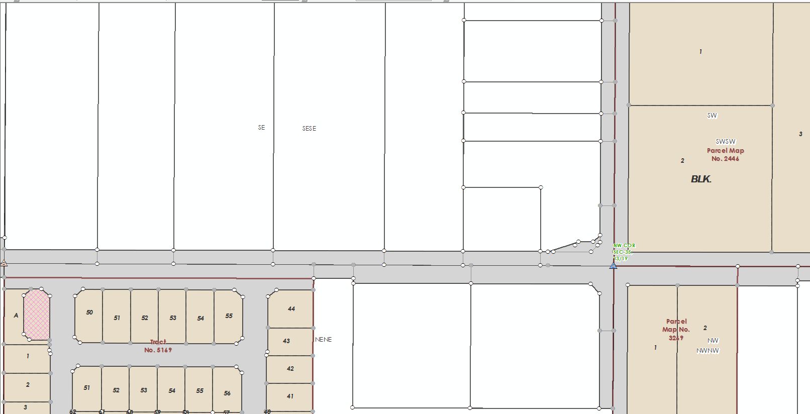
Here's an example of how right of way's look in the fabric I'm building.
In areas below where there are no recorded maps, I build the parcels first to the centerline. Once the parcels are built, I construct from parent and build in the appropriate right of way. Trying to add right of way back in would be a nightmare.
Not sure if this helps answer your question, but I've learned that you have to be very methodical when building in fabric to achieve results.