- Home
- :
- All Communities
- :
- Industries
- :
- State & Local Government
- :
- State & Local Government Questions
- :
- Shifting Data Sets all the same
- Subscribe to RSS Feed
- Mark Topic as New
- Mark Topic as Read
- Float this Topic for Current User
- Bookmark
- Subscribe
- Mute
- Printer Friendly Page
Shifting Data Sets all the same
- Mark as New
- Bookmark
- Subscribe
- Mute
- Subscribe to RSS Feed
- Permalink
- Report Inappropriate Content
Hey all,
We had control points (surveyed monuments) from a survey done a while ago and we have just re-done a survey of our counties monuments. Is there an easy way to shift all of our data at once or in pieces to new set locations.
The points we have re-surveyed are section corners and quarter corners. I was maybe thinking we could shift everything per section. I am hoping more people have noticed there are changes over time to monument locations besides changes in spatial reference and datum's.
Thanks, any thoughts are helpful.
Solved! Go to Solution.
Accepted Solutions
- Mark as New
- Bookmark
- Subscribe
- Mute
- Subscribe to RSS Feed
- Permalink
- Report Inappropriate Content
About spatial adjustment—Help | ArcGIS Desktop This whole section is for that purpose, similar to georeferencing images
- Mark as New
- Bookmark
- Subscribe
- Mute
- Subscribe to RSS Feed
- Permalink
- Report Inappropriate Content
About spatial adjustment—Help | ArcGIS Desktop This whole section is for that purpose, similar to georeferencing images
- Mark as New
- Bookmark
- Subscribe
- Mute
- Subscribe to RSS Feed
- Permalink
- Report Inappropriate Content
Hey Dan,
I think affine transformation is the method I am going to try first. However, would my process look like transforming each feature class separately or could I do all of them at once?
Thanks
- Mark as New
- Bookmark
- Subscribe
- Mute
- Subscribe to RSS Feed
- Permalink
- Report Inappropriate Content
n affine would be the choice, and if I remember you have to do them one at a time but I suspect that if you be able to apply the same transformation to all since they are referenced together in the old system.
- Mark as New
- Bookmark
- Subscribe
- Mute
- Subscribe to RSS Feed
- Permalink
- Report Inappropriate Content
If all the feature classes reside in the same Feature Dataset, they can be done en masse. (coincidentally, I'm actually doing this exact process at this very moment).
Go into Editing Mode, then on the Spatial Adjustment Toolbar click on the word Spatial Adjustment, then click Set Adjust Data...

Then change the radio button to "All features in these layers" and put a check in the boxes on the layers you want to Adjust.

Then proceed with the rest of the spatial adjustment process.
Chris Donohue, GISP
- Mark as New
- Bookmark
- Subscribe
- Mute
- Subscribe to RSS Feed
- Permalink
- Report Inappropriate Content
Chris,
I was even able to shift everything together without putting them in the same feature dataset. However, I had all of the features in the same GDB.
Thanks for all of the help!
- Mark as New
- Bookmark
- Subscribe
- Mute
- Subscribe to RSS Feed
- Permalink
- Report Inappropriate Content
Ok,
I have read the spatial adjustments outline and I am curious if there is a way to automate the linking by having the old control points and the new control points have a matching ID number.
Other wise what is the best practice to making the links? I have a lot of links so I don't want to manually do them.
thanks
- Mark as New
- Bookmark
- Subscribe
- Mute
- Subscribe to RSS Feed
- Permalink
- Report Inappropriate Content
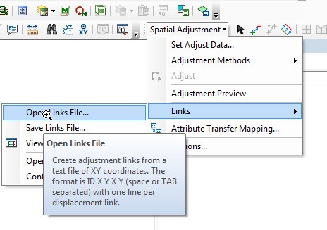
The Links Table is just a text file, so you could develop a process that outputs your Control Points to a text format (.txt). Then to do the alignment, use "Open Links File..." (or "Open Control Points File...") to load it. For the format of the text file, see the image below.
Chris Donohue, GISP
- Mark as New
- Bookmark
- Subscribe
- Mute
- Subscribe to RSS Feed
- Permalink
- Report Inappropriate Content
Chris,
I looked into using a link file. I have a txt file that has OID X Y (destination) X Y (original). I have started an edit session then tried to open the txt file to create the link and nothing happens? Am I missing something?
I checked my .txt file and it has commas in between the columns is that ok?
- Mark as New
- Bookmark
- Subscribe
- Mute
- Subscribe to RSS Feed
- Permalink
- Report Inappropriate Content
Commas won't work. Instead, the links need to be space or TAB separated (see the image I posted last - they state the format in the box below "Open Links File".
Chris Donohue, GISP