- Home
- :
- All Communities
- :
- Industries
- :
- State & Local Government
- :
- State & Local Government Questions
- :
- Sign Management Solution
- Subscribe to RSS Feed
- Mark Topic as New
- Mark Topic as Read
- Float this Topic for Current User
- Bookmark
- Subscribe
- Mute
- Printer Friendly Page
- Mark as New
- Bookmark
- Subscribe
- Mute
- Subscribe to RSS Feed
- Permalink
- Report Inappropriate Content
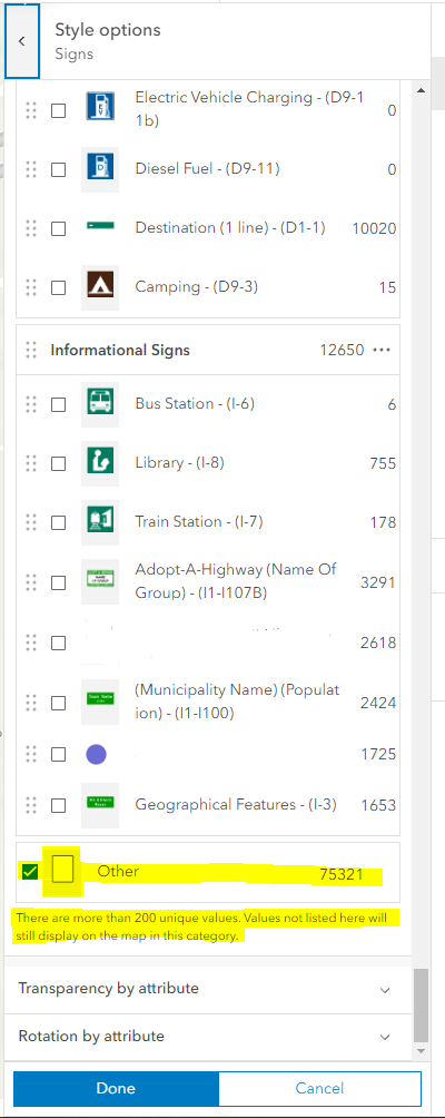
I work for a State DOT. I am currently trying to symbolize our roadway sign inventory. We deployed the Sign Management Solution ( @ScottOppmann ) in AGO. The issue I am running into is that between the MUTCD manual and our specific state signs we have more than 1,000 sign symbols. Currently I am getting an error that not more than 200 unique symbols can be created. Does anyone know how to resolve so we can use more than 200 unique symbols? Is there any accounting for Sign Inventory in Roads and Highways?
- Mark as New
- Bookmark
- Subscribe
- Mute
- Subscribe to RSS Feed
- Permalink
- Report Inappropriate Content
Know there are limitations currently on the number of unique symbols and we've been looking at options.
Am going to connect you with @ChrisFox and @DanielWickens.
They can also share with you how the Sign Management solution might be used with Road & Highways.
- Mark as New
- Bookmark
- Subscribe
- Mute
- Subscribe to RSS Feed
- Permalink
- Report Inappropriate Content
Thank you Scott. I am looking forward to finding the best way to use the Sign Management solution. One more quick question, would you happen to know if Portal has the same limitations on the number of unique symbols as Online?
I appreciate you, and any guidance that @ChrisFox and @DanielWickens can offer.
- Mark as New
- Bookmark
- Subscribe
- Mute
- Subscribe to RSS Feed
- Permalink
- Report Inappropriate Content
@VeronicaSarver - Both ArcGIS Online and ArcGIS Enterprise have the same limitation of 200 unique values. One workaround is to apply the symbology in ArcGIS Pro (where there is no limitation) and publish as a web feature layer, as described in this Esri Support KB article. I would advise you to publish the new service as a test first before swapping out any services in the solution. I'm not sure of the implications of swapping the service without testing it.
For Roads and Highways, signs are treated as event features. You can add fields to the Signs feature layer that comes with the solution that would be recognized by R+H (RouteID, Measure, Event ID, FromDate, ToDate, LocError, and Offset), and feed the data into R+H using the Append Events geoprocessing tool.
Alternatively, you can use GP tools or Arcade to calc the fields that are recognized by R+H.
- Mark as New
- Bookmark
- Subscribe
- Mute
- Subscribe to RSS Feed
- Permalink
- Report Inappropriate Content
@DanielWickens I have a custom style that has all of the MUTCD signs and State specific roadway signs. Is there a way that I can use this style in the Sign Solution? Or is there a way that I can add the signs that are specific to my state with out running into the 200 feature limit? I know I can bypass the limit by publishing from Pro, I am just unsure how the Sign Solution will recognize the custom style or if it will cause issues. Do you have any words of advice?