- Home
- :
- All Communities
- :
- Industries
- :
- Transportation
- :
- Transportation Questions
- :
- How To: Determine the best position for a road net...
- Subscribe to RSS Feed
- Mark Topic as New
- Mark Topic as Read
- Float this Topic for Current User
- Bookmark
- Subscribe
- Mute
- Printer Friendly Page
How To: Determine the best position for a road network through a Plantation forest
- Mark as New
- Bookmark
- Subscribe
- Mute
- Subscribe to RSS Feed
- Permalink
- Report Inappropriate Content
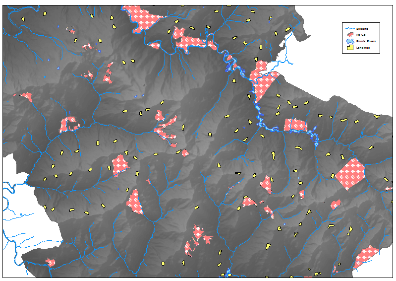
I have a surface model Raster
I have known high altitude locations that are best to harvest timber from (Landings) (these can be moved if a more optimal location can be determined by the new road network but must be at the highest location in the area with the least amount of concave surface.
I have hydrography features like streams and ponds rivers that I wish to avoid as much as practical to do so. but I can span these to harvest from opposite sides of valleys.
I wish to position a new road throughout the area that connects these high altitude locations in their shortest path using the constraint of Slope, (i.e. A road to these locations cannot be steeper than +/- 16% gradient or 4m rise/fall in 25m run ).
I will also cut and fill parts of the surface to accommodate a shorter path but I don't really wish to use more dirt in the fill than what a neighbour cut provides, within reason but can borrow soil from nearby locations to help fill.
I don't want to shift soil more the 50 metres in any direction from it's original location without using trucks to transport it to that location (so additional cost per distance and volume of soil needed to move).
The ground terrain is considered steep well beyond limits of just driving straight down the side of a hill.
I also don't want to position a road in such a way that it will impact harvest activity ie a road going through the middle of an area that can be harvested from a landing is going to slow down both the transport and the harvesting work involved. i.e having roads below a landing is a no no.
I have no go zones that I need to stay out of reserves/bush habitat locations.
Each Landing as an operable range of approximately 350 to 400 metres beyond it's location to harvest timber from using a Cable Yarder.
So what GIS tools can I use to determine, first off the best road position taking the shortest path based on slope, and also the least cost to build based on soil movement (effort) constraints and relationships to other potential harvest landing locations.
Can it all be modelled and defined automatically in GIS?
Solved! Go to Solution.
Accepted Solutions
- Mark as New
- Bookmark
- Subscribe
- Mute
- Subscribe to RSS Feed
- Permalink
- Report Inappropriate Content
This is a large and complex problem, and may be more than can be solved on an internet forum. There are various GIS techniques that can be used to solve it though. You could make a good start by reading through the techniques used in this study: http://www.diva-portal.org/smash/get/diva2:528267/FULLTEXT01.pdf. You will definitely need high resolution elevation data, for instance LiDAR at a 1 meter resolution. You might also want to move your question to a forestry related subgroup on GeoNet, such as Natural Resources, or Esri Forestry Group (EFG). If you have specific questions as you try different techniques, or attempt smaller parts of the problem, I'm sure many people on here can help you.
- Mark as New
- Bookmark
- Subscribe
- Mute
- Subscribe to RSS Feed
- Permalink
- Report Inappropriate Content
One quick question: If this is a plantation forest, how were the various areas of the forest accessed for the initial tree planting? If roads were constructed in the past, you could start with the remains of those legacy roads. Even if abandoned, these would be visible on LiDAR.
- Mark as New
- Bookmark
- Subscribe
- Mute
- Subscribe to RSS Feed
- Permalink
- Report Inappropriate Content
The Roads at planting time were created with no view to be suitable for Harvesting, they often have too tight radius bends or are too steep to be used by logging trucks. If they do exist and are in the right location we do utilise them but it is more an exception than the rule.
- Mark as New
- Bookmark
- Subscribe
- Mute
- Subscribe to RSS Feed
- Permalink
- Report Inappropriate Content
Thanks yes I wished to do so but for some reason the Forestry group was greyed out and I couldn't select it, and in as far as Natural resources were concerned I didn't want to frighten anyone with concerns about disturbing "natural" landscapes. even though all of our plantation forests have been planted on ex cattle and sheep farms that have been identified as too steep for these land uses causing all sorts of erosion problems.
- Mark as New
- Bookmark
- Subscribe
- Mute
- Subscribe to RSS Feed
- Permalink
- Report Inappropriate Content
Oh don't worry about that! Natural resources has the word resources in it for a reason  I work in forestry myself. I think you have to join the forestry group first to post there, but it is open to anyone to join. What resolution is your surface raster, by the way?
I am very interested in how you would solve this problem, I just think the answer might be too long and complex to solve in one forum post.
- Mark as New
- Bookmark
- Subscribe
- Mute
- Subscribe to RSS Feed
- Permalink
- Report Inappropriate Content
Really the raster surface is 5m in that it was derived from a tin data which in turn was derived from 5 metre contour with spotheight data , I have converted the tin to a 2m raster for the sake of trying to pick up variations between the contours more so than the contours allow for themselves. Eventually I am looking forward to LIDAR data with 4 returns per square metre so that will make a life like surface of the estate.
Thanks