- Home
- :
- All Communities
- :
- Industries
- :
- Water Resources
- :
- Water Resources Questions
- :
- How to show flow direction?
- Subscribe to RSS Feed
- Mark Topic as New
- Mark Topic as Read
- Float this Topic for Current User
- Bookmark
- Subscribe
- Mute
- Printer Friendly Page
How to show flow direction?
- Mark as New
- Bookmark
- Subscribe
- Mute
- Subscribe to RSS Feed
- Permalink
- Report Inappropriate Content
I was able to derive the catchments for each stream crossing. Now, I have two questions:
1. My question is how can i show flow direction? So that i can verify the upstream catchments generated are correct.
2. Is there a way eliminate the white gaps (between pour points and near the road alignment) between the catchments?
I have tried the vector field symbology in Flow direction raster but gives arrows not according to the streams.
I have tried the vector field symbology in the original dem raster and it gives better results but still alot of areas not in accordance with the stream generated.
I have attached a snapshot.
Thank you.
Ron
Solved! Go to Solution.
Accepted Solutions
- Mark as New
- Bookmark
- Subscribe
- Mute
- Subscribe to RSS Feed
- Permalink
- Report Inappropriate Content
Run though the Hydro Network Generation tools, that will give you a flow direction enabled flag, from which you can add arrows to the vector streams. The white "gaps" are a result of areas to the "east" of your road not falling within the same drainage area. Sounds like you need more detail than the DEM is providing. One way to do this is to "burn" the road network into the DEM by "raising" the dem a few feet where your road is, then burning through it where your culverts are. TAUDEM is much better suited for this type of catchment delineation.
- Mark as New
- Bookmark
- Subscribe
- Mute
- Subscribe to RSS Feed
- Permalink
- Report Inappropriate Content
I appreciate your prompt reply Thomas. Very encouraging for an ArcGIS beginner. I think i was able to find a way. You are correct that some streams are still missing thus producing the white gap areas. I made in flow accumulation raster - symbology>graduated>clasify range from 5,000 to 100 and it produced the missing streams. For the direction arrow, i followed a video where the methodology is resample a flow direction raster then convert it raster to point then change the symbology of the point according to direction.
I will look into your recommendation of Hydro Network Generation tools. I'll try find where i can access those tools.
Thomas, i do not understand yet the burning method you mentioned as i am beginner. I'll see also what is Taudem.
Best Regards,
Ron
- Mark as New
- Bookmark
- Subscribe
- Mute
- Subscribe to RSS Feed
- Permalink
- Report Inappropriate Content
I am still wondering why the vector field symbology is not giving the correct direction for the flow direction raster and original dem raster, any idea why?
- Mark as New
- Bookmark
- Subscribe
- Mute
- Subscribe to RSS Feed
- Permalink
- Report Inappropriate Content
screen shot?
- Mark as New
- Bookmark
- Subscribe
- Mute
- Subscribe to RSS Feed
- Permalink
- Report Inappropriate Content
Thomas,
This is the vector field symbology of original raster which shows incorrect.

This is the vector field symbology of Flow direction raster which shows incorrect direction also

This is the direction arrow from the resampled flow direction raster which shows correct

Thanks,
Ron
(U.A.E.)
- Mark as New
- Bookmark
- Subscribe
- Mute
- Subscribe to RSS Feed
- Permalink
- Report Inappropriate Content
How are you symbolizing the raster? The stream network appears to be correct (dendritic). If the flow direction raster was wrong, your stream network would look like a bowl of spaghetti.
- Mark as New
- Bookmark
- Subscribe
- Mute
- Subscribe to RSS Feed
- Permalink
- Report Inappropriate Content
Hi Thomas, here is a snapshot of vector field symbology. When i use this on the flow direction raster, arrows are incorrect.

Thanks,
Ron
- Mark as New
- Bookmark
- Subscribe
- Mute
- Subscribe to RSS Feed
- Permalink
- Report Inappropriate Content
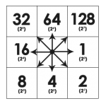
Ok you are attempting to do something with the FDR raster....that isn't supported....the FDR raster, assuming you used the D8 method (pre 10.6), results in a raster with one of 8 values for each pixel, each value an integer representation of one of (ONLY 😎 cardinal directions.
http://gisgeography.com/wp-content/uploads/2015/04/Flow-Direction-150x150.png
Convert the raster to a point feature class, and symbolize, and use rotate symbol by attribute.
- Mark as New
- Bookmark
- Subscribe
- Mute
- Subscribe to RSS Feed
- Permalink
- Report Inappropriate Content
Yes, that is how i did after resampling to arrive at the proper flow arrows.
So in 10.6, the FDR vector field symbology should work fine?