- Home
- :
- All Communities
- :
- User Groups
- :
- Web AppBuilder Custom Widgets
- :
- Documents
- :
- Advanced Identify Widget
- Subscribe to RSS Feed
- Mark as New
- Mark as Read
- Bookmark
- Subscribe
- Printer Friendly Page
- Report Inappropriate Content
Advanced Identify Widget
Hi,
The organization I work at (NASUVINSA/LURSAREA) is developing the cAAE project (Industry Catalogue of Navarre, Spain) in collaboration with the regional government. As part of the products of the project we are publishing a web app developed with Web AppBuilder. The public app allows to search for availability of industrial land as well as the current economic activities in the region. In order to improve user experience, we created together with ESRI Spain a custom widget (Advanced Identify) that allows to organize layer content in a more intuitive way. Feel free to test and use in your own projects. Although the user manual is in Spanish, I will upload an English version as soon as possible. In the meantime, do not hesitate to ask me any question. Hope you will find it useful.
You can see a live version HERE. (from November 4th 2016 on)
Looking forward to getting some feedback!
Xabier Velasco
- Mark as Read
- Mark as New
- Bookmark
- Permalink
- Report Inappropriate Content
That's great Xavier! Good Work! However the example is not accesible. It requires a user to view it 
- Mark as Read
- Mark as New
- Bookmark
- Permalink
- Report Inappropriate Content
Done!
- Mark as Read
- Mark as New
- Bookmark
- Permalink
- Report Inappropriate Content
English Version would be great! nice work.
- Mark as Read
- Mark as New
- Bookmark
- Permalink
- Report Inappropriate Content
Added to the /blogs/myAlaskaGIS/2016/03/09/web-appbuilder-developer-edition-customization-resource-list?sr=search...
But agreed, an version in English would be nice.
- Mark as Read
- Mark as New
- Bookmark
- Permalink
- Report Inappropriate Content
Hi Xabier,
Did you ever get round to creating an English version of this widget?
Regards
Anthony
- Mark as Read
- Mark as New
- Bookmark
- Permalink
- Report Inappropriate Content
I cannot access the live version please?
Why not post a video. It's free from link changes, outages
- Mark as Read
- Mark as New
- Bookmark
- Permalink
- Report Inappropriate Content
Hi!
Are you sure it is not any Internet or Web browser issue? The link is working as far as I can know, see image below (taken seconds ago)

Best regards,
Xabier
- Mark as Read
- Mark as New
- Bookmark
- Permalink
- Report Inappropriate Content
Hi Anthony,
It will be published by the end of next week. Thanks for your interest!
Best regards,
Xabier
- Mark as Read
- Mark as New
- Bookmark
- Permalink
- Report Inappropriate Content
Thank You, I'd love to try this out.
- Mark as Read
- Mark as New
- Bookmark
- Permalink
- Report Inappropriate Content
The manual is already translated, some minor fixes were applied to the advanced identify tool. See links below:
https://community.esri.com/docs/DOC-9944-widgetadvancedidentifyimplementationmanualpdf
https://community.esri.com/docs/DOC-9943-identificacionavanzadazip
I hope you will find it useful.
Next step will be to update to current WAB release.
- Mark as Read
- Mark as New
- Bookmark
- Permalink
- Report Inappropriate Content
Thanks Xabier
- Mark as Read
- Mark as New
- Bookmark
- Permalink
- Report Inappropriate Content
Hi Xabier!
Your widget looks fantastic! I'm very excited to get it running for our users. Just out of curiosity, can this widget be confgured to use ESRI Feature services or just WFS?
Thanks!
- Mark as Read
- Mark as New
- Bookmark
- Permalink
- Report Inappropriate Content
Hi Eric,
It works mainly with ESRI Feature Services. The “informacionCatastro” parameter allows for just one WFS in the configuration. I guess functionality could be expanded to allow for several WFS, but it works fine for us as it is.
Best regards,
Xabier
De: Eric McAvoy
Enviado el: jueves, 08 de junio de 2017 19:35
Para: Velasco Echeverria, Xabier (NASUVINSA)
Asunto: Re: - Advanced Identify Widget
GeoNet <https://community.esri.com/?et=watches.email.document_comment>
Advanced Identify Widget
new comment by Eric McAvoy<https://community.esri.com/people/mcavoye?et=watches.email.document_comment> View all comments on this document<https://community.esri.com/docs/DOC-8905-advanced-identify-widget?commentID=48317&et=watches.email.document_comment#comment-48317>
- Mark as Read
- Mark as New
- Bookmark
- Permalink
- Report Inappropriate Content
Hi Xabier,
It works very well to configure the attributs view...
Very good doc.
A question:
Does it work with attributes from related tables ?
Best regards
Jacques
- Mark as Read
- Mark as New
- Bookmark
- Permalink
- Report Inappropriate Content
Hi Jacques,
Not yet, although that is in our development plan.
Best regards,
Xabier
Xabier Velasco Echeverria · Jefe de Sección / Ataleko burua
Observatorio Territorial de Navarra / Nafarroako Lurralde Behatokia
<https://www.certmetrics.com/esri/public/badge.aspx?t=c&d=2012-03-06&i=7&ci=ESRI00105486>
<https://www.certmetrics.com/esri/public/badge.aspx?t=c&d=2012-12-13&i=15&ci=ESRI00105486>
<https://www.certmetrics.com/esri/public/badge.aspx?t=c&d=2013-05-13&i=20&ci=ESRI00105486>
LURSAREA - Agencia Navarra de la Sostenibilidad
•848420647 · • xvelasce@nasuvinsa.es
Navarra de Suelo y Vivienda, S.A.
Avda. San Jorge, 8 Bajo / Sanduzelaiko Etorbidea, 8 Behea - 31012 - Pamplona / Iruña
Tlf: 848420600 · Fax: 848420609 / info@nasuvinsa.es<mailto:info@nasuvinsa.es> - www.nasuvinsa.es<http://www.nasuvinsa.es/>
No me imprimas si no es necesario. Protejamos el medio ambiente/Beharrezkoa bada, ez ezazu orri hau inprimatu. Zain dezagun ingurumena
De: Jacques Brodard
Enviado el: miércoles, 30 de agosto de 2017 17:38
Para: Velasco Echeverria, Xabier (NASUVINSA)
Asunto: Re: - Advanced Identify Widget
GeoNet <https://community.esri.com/?et=watches.email.document_comment>
Advanced Identify Widget
new comment by Jacques Brodard<https://community.esri.com/people/jbrodard?et=watches.email.document_comment> View all comments on this document<https://community.esri.com/docs/DOC-8905-advanced-identify-widget?commentID=50650&et=watches.email.document_comment#comment-50650>
- Mark as Read
- Mark as New
- Bookmark
- Permalink
- Report Inappropriate Content
Hi Xabier, I'm trying to configure based on REST directory, can you let me know if this is the correct way of configuring?
Thanks!

http://gis.atlantaga.gov/dpcd/rest/services/Boundaries/Boundaries/MapServer
- Mark as Read
- Mark as New
- Bookmark
- Permalink
- Report Inappropriate Content
Hi Jacques, can you send me a quick example of how you configured the app? I'm a little confused as to what the "id", "idWebMap" refers to. Thanks!
Configuration to identify an ArcGIS service:
o id: unique identifier of the service for internal use of the Widget
o idWebMap: layer identifier in the WebMap
o camposServicio: array of field names to get from the service. If the array only
contains “*”, it will get all the fields.
- Mark as Read
- Mark as New
- Bookmark
- Permalink
- Report Inappropriate Content
Hi Leo,
You should look at the right idWebMap in your webmap's JSON. You could use ArcGIS Online Assistant to check it.
Hope this helps!
- Mark as Read
- Mark as New
- Bookmark
- Permalink
- Report Inappropriate Content
Thanks! So is "id" just a name I can give to the service? Or do I need to locate the "id" in the JSON as well.
- Mark as Read
- Mark as New
- Bookmark
- Permalink
- Report Inappropriate Content
My layers are also grouped, does it worked with grouped layers?
- Mark as Read
- Mark as New
- Bookmark
- Permalink
- Report Inappropriate Content
That is right, ID is just any name you wish to assign.
Best regards,
Xabier
- Mark as Read
- Mark as New
- Bookmark
- Permalink
- Report Inappropriate Content
Hi Leo,
As you are working with grouped layers, I assume that you use ArcGIS for Server hosted feature services. We have always used the widget with AGOL hosted feature services, but I can imagine it might work as well with AGS.
Best wishes,
Xabier
- Mark as Read
- Mark as New
- Bookmark
- Permalink
- Report Inappropriate Content
Yes, thanks for the info. I'll give it a shot and let you know.
- Mark as Read
- Mark as New
- Bookmark
- Permalink
- Report Inappropriate Content
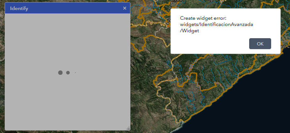
Hi Xabier. Your widget looks really great and I am trying to implement it here. I am using WAB Developer 2.7. I keep getting an error that says :Create widget error: widget/IndentificacionAvanzada/Widget. I even tried to simplify the whole config script in case I has something incorrect. I am using a MapServer service and not a FeatureServer service.
Do you know what could be causing this error?
Here is the error:
Here is my simplified config:
{
"radioIdentificacionPoligonos": 1,
"factorPaddingIdentificacionPuntosLineas": 3,
"serviciosAIdentificar": [
{
"id": "cadastre",
"idWebMap": "CityMap_9136_7",
"camposServicio": [
"*"
]
}
],
"factorZoomPoligono": 1.5,
"ajusteZoomPunto": 2,
"interfazUsuario": {
"mostrarTitulo": true,
"mostrarCheckBoxHabitilarIdentificacion": true,
"textoValorNull": "",
"paneles": [
{
"titulo": "Property",
"abiertoInicialmente": true,
"serviciosGIS": [
{
"id": "cadastre",
"resaltarTodos": true,
"informacionCatastroAsociada": false,
"campos": [
{
"campo": "SGCODE"
}
]
}
]
}
]
}
}
- Mark as Read
- Mark as New
- Bookmark
- Permalink
- Report Inappropriate Content
Hi Julian,
I am afraid this widget does not work on map services. Anyway, try the following steps:
As you have not configured the "informacionCatastro" tag, take out this line:
"informacionCatastroAsociada": false,
If that is not working, just add the following piece of code above the parameter "factorZoomPoligono" in order to trick the widget:
"informacionCatastro": {
"servicioWFS": "http://idena.navarra.es/ogc/wfs",
"sistemaReferencia": 25830,
"crs": "urn:ogc:def:crs:EPSG::25830",
"capasWFSParcelas": [
"IDENA:CATAST_Pol_ParcelaUrba",
"IDENA:CATAST_Pol_ParcelaRusti",
"IDENA:CATAST_Pol_ParcelaMixta"
],
"indiceNodoInfoCatastro": 1
},
It will not make any call to this WFS service as far as you do not use "informacionCatastroAsociada": true,
Thus, you will not get any performance issue.
Pease let me know if any of this is working.
- Mark as Read
- Mark as New
- Bookmark
- Permalink
- Report Inappropriate Content
The link to the live version is broken. Is the application still deployed or am I too late?
- Mark as Read
- Mark as New
- Bookmark
- Permalink
- Report Inappropriate Content
Hi Oscar,
Yes, it changed to
http://www.indusland.es/cAAE_PUBLICA/
Sorry,
Xabier
PD: I changed in the first entry as well