- Home
- :
- All Communities
- :
- User Groups
- :
- Web AppBuilder Custom Widgets
- :
- Documents
- :
- Traverse Widget 2.5 - 11/14/2017
- Subscribe to RSS Feed
- Mark as New
- Mark as Read
- Bookmark
- Subscribe
- Printer Friendly Page
- Report Inappropriate Content
Traverse Widget 2.5 - 11/14/2017
Traverse Widget 2.5 - 11/14/2017
11/14/2017 - Tested with WAB 2.5. Updated default linesymbol drawing to a solid line as export/import as GeoJSON had issues with a short dash line.
07/05/2017 - Fixed problem with CSS that was interfering with the attribute table display. Also added the ability to toggle the infowindow/popup display, some users want to be able to click on control points or other geometry and get more information.
12/07/2016 - Changed timeout on warning from 3 seconds to 6 seconds
12/06/2016 - Added warning to user when changing distance unit type or angle type when the traverse has courses
Popups were disabled to prevent display when drawing courses
Default values were added to the settings for DD or DMS, Quadrant or Azimuth, Distance Units and Area Units
Logic was added to allow the user to key in a file name when saving a traverse, GeoJSON or a report
12/02/2016 - Fixed problem that was preventing widget use in projections other than Web Mercator
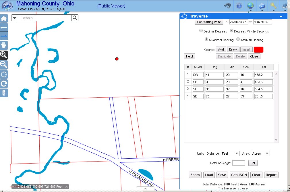
The traverse widget allows you to create, edit and save a geographic shape based on bearing and distance measurements. Course degrees can be entered in decimal degrees or degree minute second formats. Course angles can be quadrants or north azimuth angles. Course distances can be in a variety of units. The traverse can be rotated around the start point. Traverse areas and closures will always be calculated. Once created the traverse can be saved a GeoJSON shape or saved in a structure compatible with ArcMap CoGo or ParcelFabric. Saved traverse files can be loaded and used at a later time.
A demo of the traverse widget can be found here: Traverse Demo
A sample traverse text file you can use with the demo can be found here: Sample Traverse File
A help document explaining the use of the traverse widget can be found here: Help!
The creation of this widget was a collaboration between myself an Dean Anderson from Polk County, Oregon.
- Mark as Read
- Mark as New
- Bookmark
- Permalink
- Report Inappropriate Content
been awhile since there has been a new widget. 
Added to /blogs/myAlaskaGIS/2016/03/09/web-appbuilder-developer-edition-customization-resource-list
- Mark as Read
- Mark as New
- Bookmark
- Permalink
- Report Inappropriate Content
Thank You for creating this widget. Just what I need.
But in trying to use it I found some issues.
1.) Using it in draw mode on my WAB 2.2 it will not draw the line segments as in your demo site.
The drawn lines disappear on each click for another point.

2.) The "Calculate" button does not work.
3.) The "Save" button will not save to a file.
Is there something else to set up?
Any help would be appreciated.
Rich
- Mark as Read
- Mark as New
- Bookmark
- Permalink
- Report Inappropriate Content
Rich,
What browser and version are you using?
Regards,
Tom
- Mark as Read
- Mark as New
- Bookmark
- Permalink
- Report Inappropriate Content
I am using
Version 11.0.9.600.18524
Update version 11.0.37 (KB3197655)
- Mark as Read
- Mark as New
- Bookmark
- Permalink
- Report Inappropriate Content
Rich,
I did a quick test in IE to see if I might have forgotten something and the problem doesn't appear to be browser specific. Also, there isn't a calculate button. Did you maybe mean duplicate?
Here is a screen shot of my test:

You can try hitting F12 and open the developers window. Maybe there is something in your console log that will give me a clue to what might be failing.
Regards,
Tom
- Mark as Read
- Mark as New
- Bookmark
- Permalink
- Report Inappropriate Content
I meant the Report button, Sorry
- Mark as Read
- Mark as New
- Bookmark
- Permalink
- Report Inappropriate Content
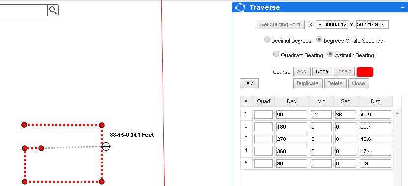
Ok, this is the error.

- Mark as Read
- Mark as New
- Bookmark
- Permalink
- Report Inappropriate Content
Rich,
Thanks! Can you please show me a complete display of your map window too. That way I can see the course list and which buttons are enabled/disabled when you are drawing courses.
What basemap are you using in your map window? Is the projection of the basemap web mercator?
Thanks for your assistance. We will get this figured out!
Regards,
Tom
- Mark as Read
- Mark as New
- Bookmark
- Permalink
- Report Inappropriate Content
Ok,
1.)I Use Local Layer 2.2 and NO Web Mercator projection
2.) BaseMap is http://mahcounty.maps.arcgis.com/home/item.html?id=80477b353a5448a9b391aaf3e8916d46
3.) Wkid = 102722 LatestWkid = 3734
4.) I can not show you the graphic Draw angles because they disappear each time I place a point
- Mark as Read
- Mark as New
- Bookmark
- Permalink
- Report Inappropriate Content
Rich,
Ok. This might be the problem. I will investigate using a projection other that web mercator. Is your web map public? If so, I could use it for testing.
Regards,
Tom
- Mark as Read
- Mark as New
- Bookmark
- Permalink
- Report Inappropriate Content
Well I just created a new test map using an ArcGIS online Base Map.
It works!
Seems that the issue is using a non ESRI Base maps or it is the Projection being non
Web Mercator.
- Mark as Read
- Mark as New
- Bookmark
- Permalink
- Report Inappropriate Content
Yes, I just shared it Public for you
- Mark as Read
- Mark as New
- Bookmark
- Permalink
- Report Inappropriate Content
Rich,
Excellent! I will have to look at adding logic for it to work in other projections. There may be a lot of folks that don't use an ESRI basemap for their web maps.
Thanks for your assistance. I believe I have a web map that uses our state plane coordinate system that I can use to test this.
Regards,
Tom
- Mark as Read
- Mark as New
- Bookmark
- Permalink
- Report Inappropriate Content
Great! I look forward to using this Widget……..
- Mark as Read
- Mark as New
- Bookmark
- Permalink
- Report Inappropriate Content
Rich,
I found and fixed the problem. Please download the widget again and let me know how it goes!
Regards,
Tom
- Mark as Read
- Mark as New
- Bookmark
- Permalink
- Report Inappropriate Content
Nice Fixes.....
Almost a perfect widget!
The Display works, The Report works, The file Save and Load works. (Fixed)
Issues Found.
1.) If I change the "txtSPwkid" to 102722 my WKID. The widget does not work properly, the line graphic display in way off.
2.) Look at the attached image. The set Starting Point should read in state plane coordinates/or ? WKID 102722, maybe a setup the config is needed for the readout of the starting point. currently using WKID 102100 and not mine of 102722
Enhancement/Request to include in widget.
1.) On loading the widget turn OFF all Layer default Popups, very cumbersome if popups are still on.
2.) Set a snap to end point and snap to edge of a line segment. This would greatly benefit the user to start a traverse at a current known point of beginning
3.) Have default setup in the config for Decimal Degrees/ DMS and Quadrant/Azimuth
Looking Great!
Rich
- Mark as Read
- Mark as New
- Bookmark
- Permalink
- Report Inappropriate Content
Rich,
Can you try using 3734 for your WKID? I think you will get a better result.
I will look into your enhancements.
Forgot about popups. That should be easy enough to fix.
Snapping should work. You must have feature layers displayed not map (image) layers of features. Feature layers provide geometry to snap against. Holding down the control key while you move the mouse around will enable snapping.
I should be able to add defaults to the config too. Good idea.
Regards,
Tom
- Mark as Read
- Mark as New
- Bookmark
- Permalink
- Report Inappropriate Content
Looking Good!
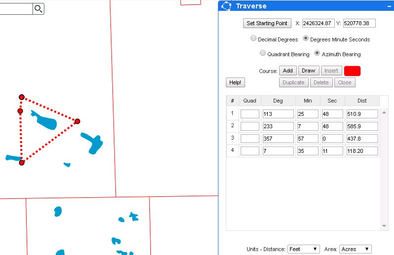
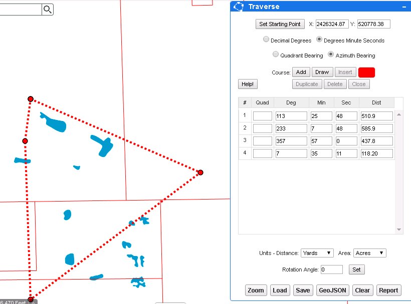
Changing the WKID fixed the unit display, but I also found this.....
Review the two images. When units are set to FEET the graphic is correct, Then change units to "YARDS"
the physical graphic size of the traverse changes not just the units.
Hope I'm helping to you de-bug issues. I hate to be a pain.......
FEET DISPLAY
YARD DISPLAY
- Mark as Read
- Mark as New
- Bookmark
- Permalink
- Report Inappropriate Content
Rich,
I think this may be a misunderstanding. These are bearing and distance measurements. Each course is drawn using the units you have selected. In this case you start drawing the courses with feet. When you switch to yards, the widget does not convert the course measurements, rather draws them using the unit selected. For instance, the first course from the starting point would be 510.9 feet or 510.9 yards depending on the unit you have selected.
I hope that makes sense...
Regards,
Tom
- Mark as Read
- Mark as New
- Bookmark
- Permalink
- Report Inappropriate Content
Yep, understood….
This question was posed to me…
So,………..
To stop others with confusion in the future.
Maybe the units should be set first before the traverse is started, lock the units, only enable a unit change after a “CLEAR”/startover.
I think that may eliminate others from asking the same question in the future as to why this happens.
Just my 2 cents
Rich
- Mark as Read
- Mark as New
- Bookmark
- Permalink
- Report Inappropriate Content
A simple way to fix confusion is to put a warning when units or radio buttons are changed when you have an active grid (in the process of actively entering/editing). The warning would be...
Warning: Each traverse can only have one set unit, bearing type, or bearing unit per traverse. Changing units, bearing types, bearing units while entering or editing a traverse will have adverse effects.
- Mark as Read
- Mark as New
- Bookmark
- Permalink
- Report Inappropriate Content
Rich,
I have posted an update. I added logic that will warn the user about possible problems when changing units or angle information when course are present. If the user was actually supposed to be keying in distances using a different unit, I don't want them to have to start all over to change to the desired units.
In addition, I have removed popups from occurring when the traverse widget is in use and added default settings for angle variables, distance and area units.
Please take a look and let me know. I appreciate your feedback!
Regards,
Tom
- Mark as Read
- Mark as New
- Bookmark
- Permalink
- Report Inappropriate Content
Dean,
I have posted an update! It does display a warning when you change those settings while courses are present in the traverse. If no courses are present, no warning will be displayed.
Regards,
Tom
- Mark as Read
- Mark as New
- Bookmark
- Permalink
- Report Inappropriate Content
Bravo!!!!
I give Tom an A+. Amazing Widget
One last comment, The "Change Unit Warning" will close before it can be fully read.. Increase timeout or shorten the text.
Rich
- Mark as Read
- Mark as New
- Bookmark
- Permalink
- Report Inappropriate Content
Rich,
I had experimented with a few different time amounts. It was set to 3 seconds, I have doubled the time for the warning to disappear automatically.
Thanks again for all your feedback. I hope this widget will work well for you!
Regards,
Tom
- Mark as Read
- Mark as New
- Bookmark
- Permalink
- Report Inappropriate Content
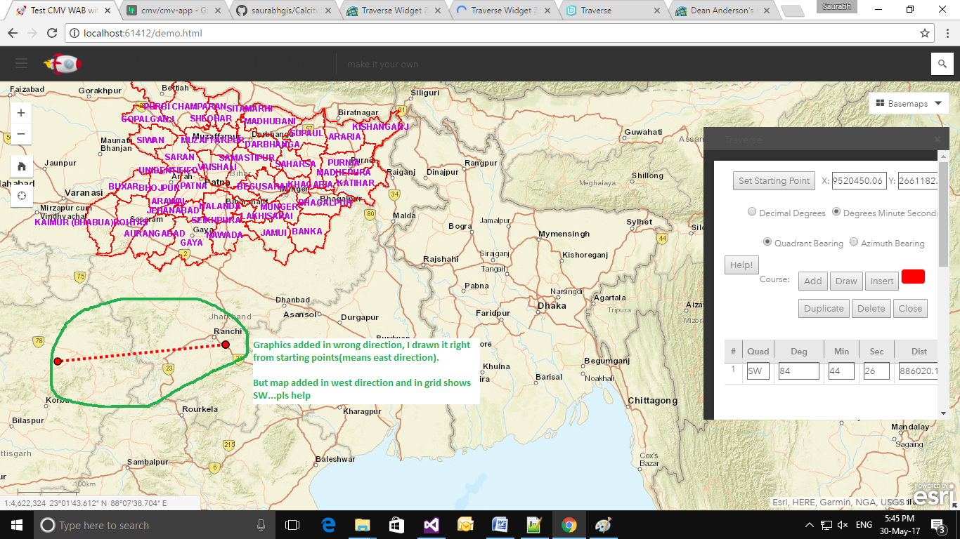
I am facing WKID realted help for india map, pls test your widget DistrictBoundary (MapServer) with this map service. directions shows incorrect please tell me where we need to change...
- Mark as Read
- Mark as New
- Bookmark
- Permalink
- Report Inappropriate Content
Do you have any plans to add the ability to draw curves (with a radius)? Or is that not possible?
- Mark as Read
- Mark as New
- Bookmark
- Permalink
- Report Inappropriate Content
Adam,
This was intended to be a simple traverse widget. I am not planning on adding curves.
Best Regards,
Tom
- Mark as Read
- Mark as New
- Bookmark
- Permalink
- Report Inappropriate Content
Thanks for letting me know.
- Mark as Read
- Mark as New
- Bookmark
- Permalink
- Report Inappropriate Content
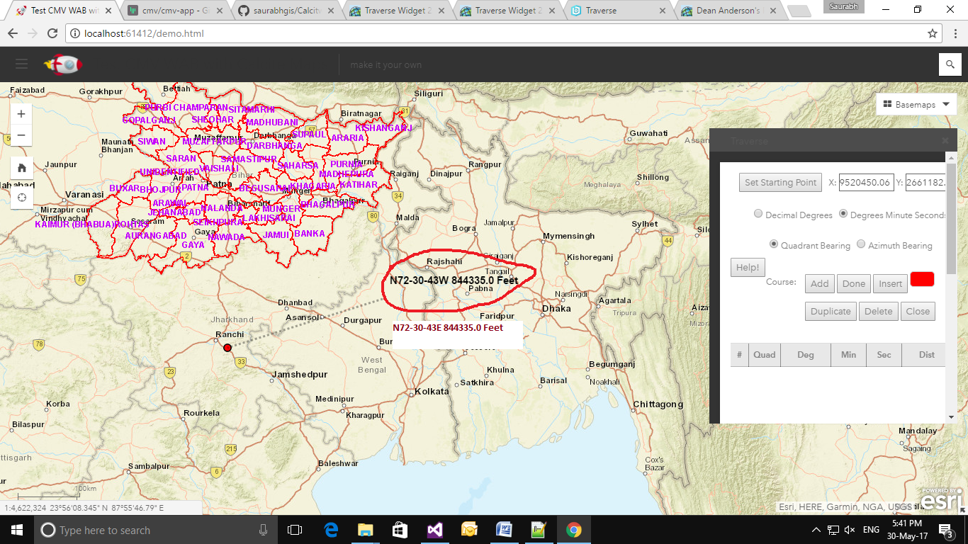
Greetings Saurabh,
Apologies for the late reply, I was out of my office last week.
Looking at the map you are using, you should be using a WKID of 102100. You are using ESRI basemaps for your app which uses web mercator (102100). I see how you might be confused as the district boundary is in a different projection, but it is drawn over an ESRI basemap which uses web mercator as its projection. I am certain you will get a desirable result when you change this in the settings dialog screen.
Here is a quick example I did in your area:

Please give this a try and let me know how it goes!
Best Regards,
Tom
- Mark as Read
- Mark as New
- Bookmark
- Permalink
- Report Inappropriate Content
 I am facing WKID realted help for india map, pls test your widget DistrictBoundary (MapServer) with this map service. directions shows incorrect please tell me where we need to change...
Thanks tsellste for reply, I will check and revert.
Regards, Saurabh
- Mark as Read
- Mark as New
- Bookmark
- Permalink
- Report Inappropriate Content
Tom, get I get you to include the "Date" of the last update in your title for this page? That way it should auto-refresh the title in my blog links. No rush....and thanks in advance.
- Mark as Read
- Mark as New
- Bookmark
- Permalink
- Report Inappropriate Content
Rebecca,
Of course. I have added the date to the title of the page.
Regards,
Tom
- Mark as Read
- Mark as New
- Bookmark
- Permalink
- Report Inappropriate Content
THANKS TOM!
- Mark as Read
- Mark as New
- Bookmark
- Permalink
- Report Inappropriate Content
Dean,
You are welcome!
Regards,
Tom
- Mark as Read
- Mark as New
- Bookmark
- Permalink
- Report Inappropriate Content
Tom Sellsted Thanks for providing us traverse widget to cover all requirements. Now I want to discuss some new thought, i want to integrate traverse widget with esri editing widget. As you know we can draw/split/merge polygon in editing widget & now we want to use length, angle via traverse grid to accurate editing.
I know you can help us to develop this functionality.
Regards,
Saurabh
- Mark as Read
- Mark as New
- Bookmark
- Permalink
- Report Inappropriate Content
Hello fellow Parcel Editors,
Just wanted everyone to know that we've released a new fully-hosted version of the Parcel Drafter, which can now be deployed directly to your portal using the solution deployment tools.
http://solutions.arcgis.com/local-government/help/parcel-drafter/
Deployment instructions:
http://solutions.arcgis.com/local-government/help/parcel-drafter/get-started/deploy-solution/
This solution supports using any basemap (WebMercator, Planar) and your own spatial reference for your parcel layer, and writes directly to feature layers. We've also added improved display of entered bearings and distances using labels in the predefined webmap, and we'll be updating this app in for the December release to include another enhancement to include X, Y start point entry.
Thanks,
Chris Buscaglia
Local Government Solutions
- Mark as Read
- Mark as New
- Bookmark
- Permalink
- Report Inappropriate Content
Rotation Angle does not seem to save to file? Is this by design?
- Mark as Read
- Mark as New
- Bookmark
- Permalink
- Report Inappropriate Content
Hunter,
The export was written so the traverse could be imported into ArcGIS if need be. In their specification, there is no allowance for the rotation angle. Here is the link to the document I used: Traverse file format—Help | ArcGIS for Desktop
Regards,
Tom
- Mark as Read
- Mark as New
- Bookmark
- Permalink
- Report Inappropriate Content
Hi Hunter - if you can take a look at the Parcel Drafter widget in core ArcGIS, which has been updated last week to no include the X, Y start point - it will persist the rotation angle since it saves both the coordinate geometry and rotation, misclose info, etc. as attributes.
Chris
- Mark as Read
- Mark as New
- Bookmark
- Permalink
- Report Inappropriate Content
First of all, let me say you have done a great job with this widget. We have already implemented your Measure Widget in one of our apps as well.
But we are currently having a challenge snapping against a feature layer with the Traverse Widget. The Draw widget (and your Measure Widget) snap as expected while holding down the CTRL key - I have attached a screenshot of this behavior below.
I certainly appreciate this widget and any help you may provide with this snapping challenge - thanks in advance!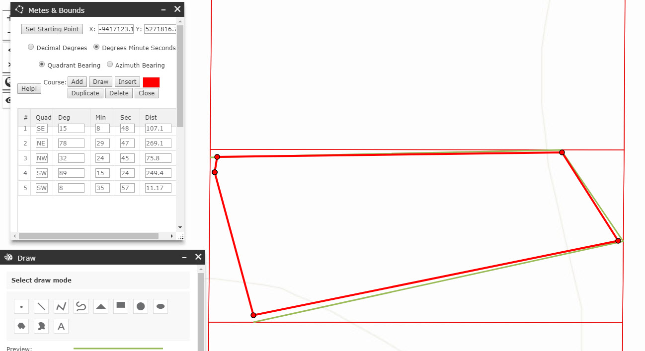
- Mark as Read
- Mark as New
- Bookmark
- Permalink
- Report Inappropriate Content
Hello ,
Does this widget work for web app builder developer edition 2.9
- Mark as Read
- Mark as New
- Bookmark
- Permalink
- Report Inappropriate Content
I'm using it with WABDE 2.14 and it works in Portal WAB too
- Mark as Read
- Mark as New
- Bookmark
- Permalink
- Report Inappropriate Content
Thank you !! @Brain Wilson for a helpful comment