Turn on suggestions
Auto-suggest helps you quickly narrow down your search results by suggesting possible matches as you type.
Cancel
- Home
- :
- All Communities
- :
- Products
- :
- ModelBuilder
- :
- ModelBuilder Questions
- :
- ModelBuilder crashes frequently
Options
- Subscribe to RSS Feed
- Mark Topic as New
- Mark Topic as Read
- Float this Topic for Current User
- Bookmark
- Subscribe
- Mute
- Printer Friendly Page
09-12-2013
06:57 AM
- Mark as New
- Bookmark
- Subscribe
- Mute
- Subscribe to RSS Feed
- Permalink
- Report Inappropriate Content
Good morning all. I am trying my hand at building re-usable models to help me speed up map assembly. What seemed like an initially great idea - visually processing data - is turning into a nightmare.
The ModelBuilder (MB) crashes on a pretty simple sequence, and takes down ArcGIS and ArcCatalog with it.
I think I have narrowed down the point at which the crash occurs, but need some help figuring out how to fix the problem or avoid it.
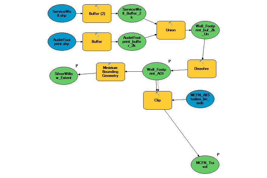
I begin with a pair of shapefiles with features that overlap geographically, buffer each of them with 2000 distance, union the two resulting buffer files, and dissolve the resulting union feature set into 1 overall polygon. So far so good.
The problem seems to crop up when I branch off that resulting feature set into two directions. One direction leads to creating a minimum bounding geometry envelope, a rectangle, that will form the extent for my intended map. The other direction leads to a clip function, that uses the resulting polygon feature as a clip feature for another input stream, a second input stream of other data.
I want to achieve a set of points, lines and polygon features all clipped to the same dissolved polygon result from above.
I can eliminate the first branch, the minimum bounding geometry envelope, and the clip seems to work. Or I can eliminate the clip and the bounding envelope seems to work. Just not both.
Any ideas what is happening here? The help files and tutorials clearly show branching of output to act as input to more than 1 direction in subsequent steps, but those help files are resolutely silent on how to correctly set them up without crashing.
Thanks,
Russell Collier
ps: I am not a programmer, though I can tweak scripts at need, and understand some basics of programming.
The ModelBuilder (MB) crashes on a pretty simple sequence, and takes down ArcGIS and ArcCatalog with it.
I think I have narrowed down the point at which the crash occurs, but need some help figuring out how to fix the problem or avoid it.
I begin with a pair of shapefiles with features that overlap geographically, buffer each of them with 2000 distance, union the two resulting buffer files, and dissolve the resulting union feature set into 1 overall polygon. So far so good.
The problem seems to crop up when I branch off that resulting feature set into two directions. One direction leads to creating a minimum bounding geometry envelope, a rectangle, that will form the extent for my intended map. The other direction leads to a clip function, that uses the resulting polygon feature as a clip feature for another input stream, a second input stream of other data.
I want to achieve a set of points, lines and polygon features all clipped to the same dissolved polygon result from above.
I can eliminate the first branch, the minimum bounding geometry envelope, and the clip seems to work. Or I can eliminate the clip and the bounding envelope seems to work. Just not both.
Any ideas what is happening here? The help files and tutorials clearly show branching of output to act as input to more than 1 direction in subsequent steps, but those help files are resolutely silent on how to correctly set them up without crashing.
Thanks,
Russell Collier
ps: I am not a programmer, though I can tweak scripts at need, and understand some basics of programming.
Solved! Go to Solution.
1 Solution
Accepted Solutions
09-12-2013
03:25 PM
- Mark as New
- Bookmark
- Subscribe
- Mute
- Subscribe to RSS Feed
- Permalink
- Report Inappropriate Content
Okay, I tested this workaround above on some datasets that may or may not contain features that can be clipped, 3 sets, one of points, one of lines, the 3rd of polygons. All three test for ability to select by location, as in the image shown below. They are all exactly the same, except for the input features.
[ATTACH=CONFIG]27412[/ATTACH]
These worked for me. I then built a new model, and copied the working models in as submodels, and used the output of each submodel as input for the clip function for each of three processing lines, as shown below.
[ATTACH=CONFIG]27413[/ATTACH]
It all worked! Glory be! The models do create feature layers and add them to the map, even if they are empty. This is fine for me, as it is at least a bit more information about availability of data for the clip location. It also lets the rest of the model run unimpeded, no crashes.
The models are sufficiently modular that I can combine them and re-use them for many data preparation jobs.
A note about the workaround:
You have to have data loaded into the map first, in order for the Select By Location function to have something to select from. I could not get it to recognize the MDB file or shapefiles I had sitting in a folder; it had to be first loaded into the map. I am processing a lot of files, and so I use a simple "Files to be Processed" and "Files Processed Keepers" group layer method of organizing them. Once they are all processed, I'll delete everything that is superfluous and use my newly clipped data as my starting point for a map.
A note about ModelBuider:
I am a highly visual person who likes the idea of ModelBuilder a lot. I used to use FME software ages ago and liked it then. I can tweak code, e.g., Python, but I don't have the time to learn to program in the way that ESRI seems to want me to move. If there any ESRI folks out there who ever read these forum posts and particularly our answers to bugs, please, please do us a favour and get us a major update for ModelBuilder.
Okay, that's all folks.
Russell Collier
3 Replies
09-12-2013
02:10 PM
- Mark as New
- Bookmark
- Subscribe
- Mute
- Subscribe to RSS Feed
- Permalink
- Report Inappropriate Content
Okay, I found what seems to be the cause and a workaround for the problem. Nestled deep in some ancient archives, I found that this particular bug has been with us since at least 2006, maybe earlier. I don't think it's going to be fixed folks, which leads me to suspect ModelBuilder itself is not undergoing any serious updating.
At this location http://forums.esri.com/thread.asp?c=93&f=1728&t=193385#589995 a fellow named Keith Brooks suggested trying to select by location first, and then run that result as input to the clip function. Essentially, clip, when run inside ModelBuilder, crashes everything if there is nothing to clip within the clipping polygon.
This kludge tests first if there is anything to that can be clipped. The clip function then politely tells the user that there is nothing to clip, does not create an empty feature set, and lets the rest of the model run.
Here is the model snippet he used, and which I tested (it works so far).
[ATTACH=CONFIG]27411[/ATTACH]
Happiness, for now. And earnest wishes that ModelBuilder will someday be updated with serious bug fixing.
Russell
09-12-2013
03:25 PM
- Mark as New
- Bookmark
- Subscribe
- Mute
- Subscribe to RSS Feed
- Permalink
- Report Inappropriate Content
Okay, I tested this workaround above on some datasets that may or may not contain features that can be clipped, 3 sets, one of points, one of lines, the 3rd of polygons. All three test for ability to select by location, as in the image shown below. They are all exactly the same, except for the input features.
[ATTACH=CONFIG]27412[/ATTACH]
These worked for me. I then built a new model, and copied the working models in as submodels, and used the output of each submodel as input for the clip function for each of three processing lines, as shown below.
[ATTACH=CONFIG]27413[/ATTACH]
It all worked! Glory be! The models do create feature layers and add them to the map, even if they are empty. This is fine for me, as it is at least a bit more information about availability of data for the clip location. It also lets the rest of the model run unimpeded, no crashes.
The models are sufficiently modular that I can combine them and re-use them for many data preparation jobs.
A note about the workaround:
You have to have data loaded into the map first, in order for the Select By Location function to have something to select from. I could not get it to recognize the MDB file or shapefiles I had sitting in a folder; it had to be first loaded into the map. I am processing a lot of files, and so I use a simple "Files to be Processed" and "Files Processed Keepers" group layer method of organizing them. Once they are all processed, I'll delete everything that is superfluous and use my newly clipped data as my starting point for a map.
A note about ModelBuider:
I am a highly visual person who likes the idea of ModelBuilder a lot. I used to use FME software ages ago and liked it then. I can tweak code, e.g., Python, but I don't have the time to learn to program in the way that ESRI seems to want me to move. If there any ESRI folks out there who ever read these forum posts and particularly our answers to bugs, please, please do us a favour and get us a major update for ModelBuilder.
Okay, that's all folks.
Russell Collier
[ATTACH=CONFIG]27412[/ATTACH]
These worked for me. I then built a new model, and copied the working models in as submodels, and used the output of each submodel as input for the clip function for each of three processing lines, as shown below.
[ATTACH=CONFIG]27413[/ATTACH]
It all worked! Glory be! The models do create feature layers and add them to the map, even if they are empty. This is fine for me, as it is at least a bit more information about availability of data for the clip location. It also lets the rest of the model run unimpeded, no crashes.
The models are sufficiently modular that I can combine them and re-use them for many data preparation jobs.
A note about the workaround:
You have to have data loaded into the map first, in order for the Select By Location function to have something to select from. I could not get it to recognize the MDB file or shapefiles I had sitting in a folder; it had to be first loaded into the map. I am processing a lot of files, and so I use a simple "Files to be Processed" and "Files Processed Keepers" group layer method of organizing them. Once they are all processed, I'll delete everything that is superfluous and use my newly clipped data as my starting point for a map.
A note about ModelBuider:
I am a highly visual person who likes the idea of ModelBuilder a lot. I used to use FME software ages ago and liked it then. I can tweak code, e.g., Python, but I don't have the time to learn to program in the way that ESRI seems to want me to move. If there any ESRI folks out there who ever read these forum posts and particularly our answers to bugs, please, please do us a favour and get us a major update for ModelBuilder.
Okay, that's all folks.
Russell Collier
06-04-2014
11:57 PM
- Mark as New
- Bookmark
- Subscribe
- Mute
- Subscribe to RSS Feed
- Permalink
- Report Inappropriate Content
Hi Russell
I have to agree with you, ESRI has essentially neglected ArcGIS Modelbuilder, it crashes frequently, its unstable, has a large amount of bugs that till today have not been fixed. This is very poor from ESRI side to release a product and then not ensure its maintained and fixed when users have reported errors years ago.
Regards