Turn on suggestions
Auto-suggest helps you quickly narrow down your search results by suggesting possible matches as you type.
Cancel
- Home
- :
- All Communities
- :
- Developers
- :
- Native Maps SDKs
- :
- Runtime SDK WPF (Retired) Ques
- :
- Problem getting EditorWidget to work with a Featur...
Options
- Subscribe to RSS Feed
- Mark Topic as New
- Mark Topic as Read
- Float this Topic for Current User
- Bookmark
- Subscribe
- Mute
- Printer Friendly Page
Problem getting EditorWidget to work with a Feature Service on ArcGIS Server
Subscribe
02-12-2014
05:17 AM
- Mark as New
- Bookmark
- Subscribe
- Mute
- Subscribe to RSS Feed
- Permalink
- Report Inappropriate Content
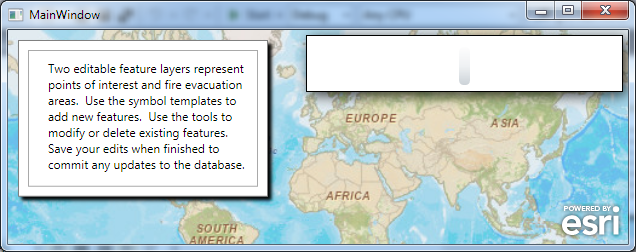
I am trying to get the ArcGIS Runtime SDK for WPF 10.2 sample named "Editor Widget Online" to work with a Feature Service that I am hosying on my own ArcGIS 10.2 for Server.
What I have done is simply this:
1. Pasted the xaml for the sample into a new "ArcGIS Runtime SDK 10.2 for WPF Application" created in Visual Studio 2012.
2. Edited the xaml to remove the dynamic map service layer and one of the two Feature Layers from the Map and to change the other Feature Layer to point to the url of my own feature service.
When I start the application, there are no errors (and no exception in debug), put the editor widget looks very weird:
[ATTACH=CONFIG]31343[/ATTACH]
Any thoughts?
The feature service works fine with the TemplatePicker and the application works fine if I do not change the xaml form the sample.
xaml:
<Window x:Class="BarrierEditor2.MainWindow"
xmlns="http://schemas.microsoft.com/winfx/2006/xaml/presentation"
xmlns:x="http://schemas.microsoft.com/winfx/2006/xaml"
xmlns:esri="http://schemas.esri.com/arcgis/client/2009"
Title="MainWindow" Height="350" Width="525">
<Grid x:Name="LayoutRoot">
<Grid.Resources>
</Grid.Resources>
<esri:Map x:Name="MyMap" WrapAround="True" UseAcceleratedDisplay="True">
<esri:ArcGISTiledMapServiceLayer ID="BaseLayer"
Url="http://services.arcgisonline.com/ArcGIS/rest/services/World_Street_Map/MapServer" />
<!--<esri:ArcGISDynamicMapServiceLayer ID="Fire Perimeter"
Url="http://sampleserver3.arcgisonline.com/ArcGIS/rest/services/Fire/Sheep/MapServer"
VisibleLayers="2"/>-->
<esri:FeatureLayer ID="Barrier2" DisableClientCaching="True"
AutoSave="False"
Url="http://ags102test:6080/arcgis/rest/services/BarrierEdit/FeatureServer/0"
OutFields="*"
/>
<!--<esri:FeatureLayer ID="Points of Interest" DisableClientCaching="True"
AutoSave="False"
Url="http://sampleserver3.arcgisonline.com/ArcGIS/rest/services/Fire/Sheep/FeatureServer/0"
OutFields="*" />-->
</esri:Map>
<StackPanel x:Name="EditorToolStrip" Margin="0,5,5,0" >
<Border Background="White" BorderThickness="1"
HorizontalAlignment="Right" VerticalAlignment="Top"
Padding="5" BorderBrush="Black">
<Border.Effect>
<DropShadowEffect Color="Black" Direction="-45" BlurRadius="20" Opacity=".75" />
</Border.Effect>
<StackPanel Orientation="Vertical" HorizontalAlignment="Right" Margin="0,5,5,0" VerticalAlignment="Top" >
<esri:EditorWidget x:Name="MyEditorWidget" Map="{Binding ElementName=MyMap}"
Width="300"
LayerIDs="Barriers2"
AutoSelect="False"
GeometryServiceUrl="http://ags102test:6080/arcgis/rest/services/Utilities/Geometry/GeometryServer"
ShowAttributesOnAdd="True" />
</StackPanel>
</Border>
</StackPanel>
<Grid HorizontalAlignment="Left" VerticalAlignment="Top" Margin="10,10,10,0" >
<Rectangle Fill="White" Stroke="Gray" Margin="0,0,0,5">
<Rectangle.Effect>
<DropShadowEffect/>
</Rectangle.Effect>
</Rectangle>
<Rectangle Fill="#FFFFFFFF" Stroke="DarkGray" Margin="10,10,10,15" />
<TextBlock x:Name="ResponseTextBlock" Text="Two editable feature layers represent points of interest and fire evacuation areas. Use the symbol templates to add new features. Use the tools to modify or delete existing features. Save your edits when finished to commit any updates to the database."
Width="200" TextAlignment="Left" Margin="30,20,20,30" TextWrapping="Wrap" Foreground="Black" />
</Grid>
</Grid>
</Window>
Feature Service:
Layer: RlpTest.DBO.SoftBarriers (ID: 0)
View In: ArcGIS.com Map
Name: RlpTest.DBO.SoftBarriers
Display Field: ScaleFactor
Type: Feature Layer
Geometry Type: esriGeometryPolygon
Description:
Definition Expression: N/A
Copyright Text:
Default Visibility: true
MaxRecordCount: 1000
Supported Query Formats: JSON, AMF
Min Scale: 0
Max Scale: 0
Supports Advanced Queries: true
Supports Statistics: true
Use Standardized Queries: true
Extent:
XMin: 335252.9430999998
YMin: 5888684.078400001
XMax: 968397.0930000003
YMax: 6606555.6579
Spatial Reference: 25832 (25832)
Drawing Info:
Renderer:
Unique Value Renderer:
Field 1: ScaleType
Field 2: null
Field 3: null
Field Delimiter: ,
Default Symbol:
Style: esriSFSSolid
Color: [238, 205, 247, 255]
Outline:
Style: esriSLSSolid
Color: [110, 110, 110, 255]
Width: 0
Default Label:
UniqueValueInfos:
Value: 2
Label: High
Description:
Symbol:
Style: esriSFSSolid
Color: [201, 242, 208, 255]
Outline:
Style: esriSLSSolid
Color: [110, 110, 110, 255]
Width: 0
Value: 1
Label: Low
Description:
Symbol:
Style: esriSFSSolid
Color: [205, 233, 247, 255]
Outline:
Style: esriSLSSolid
Color: [110, 110, 110, 255]
Width: 0
Transparency: 0
Labeling Info:
HasZ: false
HasM: false
Has Attachments: false
HTML Popup Type: esriServerHTMLPopupTypeAsHTMLText
Type ID Field: ScaleType
Fields:
OBJECTID ( type: esriFieldTypeOID , alias: OBJECTID , editable: false , nullable: false )
ScaleFactor ( type: esriFieldTypeDouble , alias: ScaleFactor , editable: true , nullable: false )
ScaleType ( type: esriFieldTypeSmallInteger , alias: ScaleType , editable: true , nullable: true )
Types:
ID: 1
Name: Low
Domains:
ScaleFactor:
Range: [0, 0.5]
Templates:
Name: Low
Description:
Prototype:
ScaleFactor: 0.25
ScaleType: 1
Drawing Tool: esriFeatureEditToolPolygon
--------------------------------------------------------------------------------
ID: 2
Name: High
Domains:
ScaleFactor:
Range: [0.5, 1]
Templates:
Name: High
Description:
Prototype:
ScaleFactor: 0.75
ScaleType: 2
Drawing Tool: esriFeatureEditToolPolygon
--------------------------------------------------------------------------------
Capabilities: Create,Delete,Query,Update,Uploads,Editing
Sync Can Return Changes: false
Is Data Versioned: false
Supports Rollback On Failure: true
Supported Operations: Query Apply Edits Add Features Update Features Delete Features Generate Renderer Return Updates
Solved! Go to Solution.
1 Solution
Accepted Solutions
02-25-2014
07:51 AM
- Mark as New
- Bookmark
- Subscribe
- Mute
- Subscribe to RSS Feed
- Permalink
- Report Inappropriate Content
Turns out there was an errors in the xaml: Mismatch in layer names.
Feature Request for ArcGIS Runtime SDK: Please have the EditorWidget throw useful exceptions when it it provided with obviously invalid inputs, such as asking it to use a non-existant layer.
Feature Request for ArcGIS Runtime SDK: Please have the EditorWidget throw useful exceptions when it it provided with obviously invalid inputs, such as asking it to use a non-existant layer.
1 Reply
02-25-2014
07:51 AM
- Mark as New
- Bookmark
- Subscribe
- Mute
- Subscribe to RSS Feed
- Permalink
- Report Inappropriate Content
Turns out there was an errors in the xaml: Mismatch in layer names.
Feature Request for ArcGIS Runtime SDK: Please have the EditorWidget throw useful exceptions when it it provided with obviously invalid inputs, such as asking it to use a non-existant layer.
Feature Request for ArcGIS Runtime SDK: Please have the EditorWidget throw useful exceptions when it it provided with obviously invalid inputs, such as asking it to use a non-existant layer.