Turn on suggestions
Auto-suggest helps you quickly narrow down your search results by suggesting possible matches as you type.
Cancel
- Home
- :
- All Communities
- :
- Industries
- :
- Water Resources
- :
- Water Resources Questions
- :
- DEM Reconditioning error (Arc Hydro 10.2)
Options
- Subscribe to RSS Feed
- Mark Topic as New
- Mark Topic as Read
- Float this Topic for Current User
- Bookmark
- Subscribe
- Mute
- Printer Friendly Page
DEM Reconditioning error (Arc Hydro 10.2)
Subscribe
7846
14
03-22-2014 10:34 AM
03-22-2014
10:34 AM
- Mark as New
- Bookmark
- Subscribe
- Mute
- Subscribe to RSS Feed
- Permalink
- Report Inappropriate Content
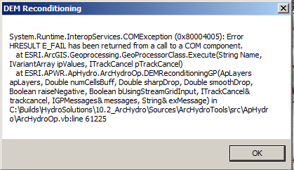
I am facing a problem using the arc hydro tools 10.2 fonctionnality "DEM Reconditioning" and you can check the error message in the image attached and i have no idea what i should do, so would please land me a hand.
Houssem Daagi
[ATTACH=CONFIG]32416[/ATTACH]
Houssem Daagi
[ATTACH=CONFIG]32416[/ATTACH]
14 Replies
03-23-2014
11:06 PM
- Mark as New
- Bookmark
- Subscribe
- Mute
- Subscribe to RSS Feed
- Permalink
- Report Inappropriate Content
Specifying a geodatabase layer as the output instead of a shapefile will fix the error. Also make sure you have all the necessary default fields in the feature class.
03-24-2014
07:53 AM
- Mark as New
- Bookmark
- Subscribe
- Mute
- Subscribe to RSS Feed
- Permalink
- Report Inappropriate Content
I'm linking to this good advice in the "Arc Hydro Problem Solvers" thread. Thanks!
03-24-2014
08:25 AM
- Mark as New
- Bookmark
- Subscribe
- Mute
- Subscribe to RSS Feed
- Permalink
- Report Inappropriate Content
Ah. "Arc Hydro Problem Solvers" thread. That's a good idea. It will be helpful for the users. Great effort!
03-25-2014
11:17 AM
- Mark as New
- Bookmark
- Subscribe
- Mute
- Subscribe to RSS Feed
- Permalink
- Report Inappropriate Content
03-26-2014
09:44 AM
- Mark as New
- Bookmark
- Subscribe
- Mute
- Subscribe to RSS Feed
- Permalink
- Report Inappropriate Content
The target locations are set via the Arc Hydro toolbar. After choosing "Set Target Locations" choose "hydroconfig". This should give you the default locations for the Arc Hydro geoprocessing.
[ATTACH=CONFIG]32532[/ATTACH]
I rarely set this manually. I use the "Reset Target Locations" tool shown in the pic below. If your mxd is saved in a different plance than when you started the Arc Hydro project, resetting the target locations is required so Arc Hydro knows where to get and put the data.
[ATTACH=CONFIG]32533[/ATTACH]
Also, doing processing over a network can result in errors like this. Check out the Arc Hydro Problem Solvers via the link below my signature for other solutions to Arc Hydro problems.
Hope this helps.
03-28-2014
11:30 AM
- Mark as New
- Bookmark
- Subscribe
- Mute
- Subscribe to RSS Feed
- Permalink
- Report Inappropriate Content
I am getting a very similar runtime error with any tool that I try to use. I reset the target locations to the defaults as recommended, but still have the error.
Could someone please elaborate on this advice from nidhidkn:
<<Specifying a geodatabase layer as the output instead of a shapefile will fix the error. Also make sure you have all the necessary default fields in the feature class.>>
I'm confused because when I tried to point the raster outputs to a file geodatabase, it wouldn't let me since rasters have to be in data folders, and cannot be stored in geodatabases.
03-28-2014
12:15 PM
- Mark as New
- Bookmark
- Subscribe
- Mute
- Subscribe to RSS Feed
- Permalink
- Report Inappropriate Content
In my Arc Hydro experience, the rasters used in Arc Hydro go to a folder with the same name as the Data Frame. The vector data goes in a dataset with the Data Frame name inside a geodatabase with the mxd name. The rasters do not go to a geodatabase.
04-30-2014
12:03 PM
- Mark as New
- Bookmark
- Subscribe
- Mute
- Subscribe to RSS Feed
- Permalink
- Report Inappropriate Content
I am also having a very similar error, where even if I try to reset my target locations it is still having a fit.
[ATTACH=CONFIG]33489[/ATTACH]
I have installed the latest version that was just published 2 days ago and I get even more errors now.
Any help would be greatly appreciated.
[ATTACH=CONFIG]33489[/ATTACH]
I have installed the latest version that was just published 2 days ago and I get even more errors now.
Any help would be greatly appreciated.
05-07-2014
07:29 AM
- Mark as New
- Bookmark
- Subscribe
- Mute
- Subscribe to RSS Feed
- Permalink
- Report Inappropriate Content
When I see "Error HRESULT E_FAIL has been returned from a call to a COM component" I immediately consider working on the project with the Arc Hydro data on my local drive and not on the network. For me this has fixed many otherwise unexplained errors and has sped up the processing significantly. I've posted this and other solutions in the link below my signature.