- Home
- :
- All Communities
- :
- Developers
- :
- Native Maps SDKs
- :
- Runtime SDK WPF (Retired) Ques
- :
- Strange effect it seems arcgis (10.2.3) for WPF sh...
- Subscribe to RSS Feed
- Mark Topic as New
- Mark Topic as Read
- Float this Topic for Current User
- Bookmark
- Subscribe
- Mute
- Printer Friendly Page
Strange effect it seems arcgis (10.2.3) for WPF shows tiles of multiple zoom levels
- Mark as New
- Bookmark
- Subscribe
- Mute
- Subscribe to RSS Feed
- Permalink
- Report Inappropriate Content
As I do not expect any response on Stackoverflow (.net - Strange effect it seems arcgis (10.2.3) shows tiles of multiple zoom levels - Stack Overflow), I wanted to try it here.
I have to layers one base layer and an overlay layer with transparent tiles containing only seamarks, My XAML looks like that:
   <esri:MapView x:Name="MyMapView" Grid.ColumnSpan="2" Margin="0,0,10,0" DragEnter="MyMapView_DragEnter" DragLeave="MyMapView_DragLeave" MouseDoubleClick="MyMapView_MouseDoubleClick" MouseLeftButtonDown="MyMapView_MouseLeftButtonDown" MouseLeftButtonUp="MyMapView_MouseLeftButtonUp" MouseMove="MyMapView_MouseMove">
   <esri:Map x:Name="MyMap" >
   <esri:ArcGISTiledMapServiceLayer ID="BaseMap"
ServiceUri="http://services.arcgisonline.com/ArcGIS/rest/services/World_Street_Map/MapServer"/>
   <esri:OpenStreetMapLayer ID="SeamarkMap" DisplayName="SeamarkMap" TemplateUri="http://tiles.openseamap.org/seamark/{level}/{col}/{row}.png" />
   </esri:Map>
   </esri:MapView>
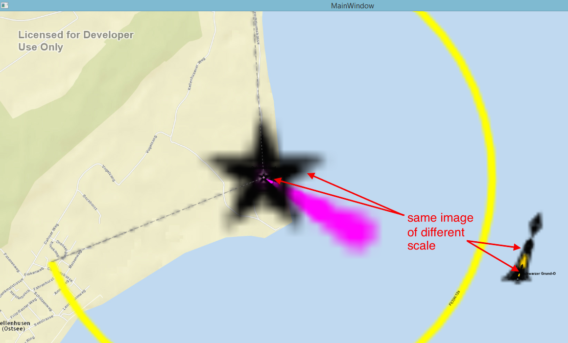
All maks of the SeamarkMap-Layer are rendered but if I zoom in, Images like the attatched one come out. It seems like on a layer Tiles of different zoom levels and scale remain visible. Did I a configuration mistake or is it a Bug?
- Mark as New
- Bookmark
- Subscribe
- Mute
- Subscribe to RSS Feed
- Permalink
- Report Inappropriate Content
Hi,
Your code indicates it is not the 'ArcGIS Runtime SDK for WPF' which you are working with, but rather the beta ArcGIS Runtime SDK for .NET. Until it is released (later this summer) please post questions regarding the new .NET SDK in the beta forum: https://betacommunity.esri.com/home.html.
Cheers
Mike