- Home
- :
- All Communities
- :
- User Groups
- :
- Coordinate Reference Systems
- :
- Questions
- :
- Shape file doesn't line up with world imagery
- Subscribe to RSS Feed
- Mark Topic as New
- Mark Topic as Read
- Float this Topic for Current User
- Bookmark
- Subscribe
- Mute
- Printer Friendly Page
Shape file doesn't line up with world imagery
- Mark as New
- Bookmark
- Subscribe
- Mute
- Subscribe to RSS Feed
- Permalink
- Report Inappropriate Content
I have a question maybe someone can help with- I have a world imagery layer from Arcgis online and a shape file, they don't quite line up (they are in different coordinate systems). When I change the shapefile coordinate system to match the world imagery layer, it ends up out in space or doesn't show up at all. The layers do not appear in the georeferencing tool bar. Any ideas? I think it must be a simple fix.......
- Mark as New
- Bookmark
- Subscribe
- Mute
- Subscribe to RSS Feed
- Permalink
- Report Inappropriate Content
Could you clarify what you mean by they don't quite line up? Maybe provide a screen shot for us to see.
Do you mean the differences are small and are they consistantly off by the same amount in one direction? or are they off by a random amount in any given direction? There could be many factors at play here including the accuracy of the world imagery or the accuracy of your shp file, even a transformation issue. Without seeing what you are working with it would be tough to pin point it.
- Mark as New
- Bookmark
- Subscribe
- Mute
- Subscribe to RSS Feed
- Permalink
- Report Inappropriate Content
- Mark as New
- Bookmark
- Subscribe
- Mute
- Subscribe to RSS Feed
- Permalink
- Report Inappropriate Content
Thanks for posting the screen shot. What coordinate system is your shp file in?
- Mark as New
- Bookmark
- Subscribe
- Mute
- Subscribe to RSS Feed
- Permalink
- Report Inappropriate Content
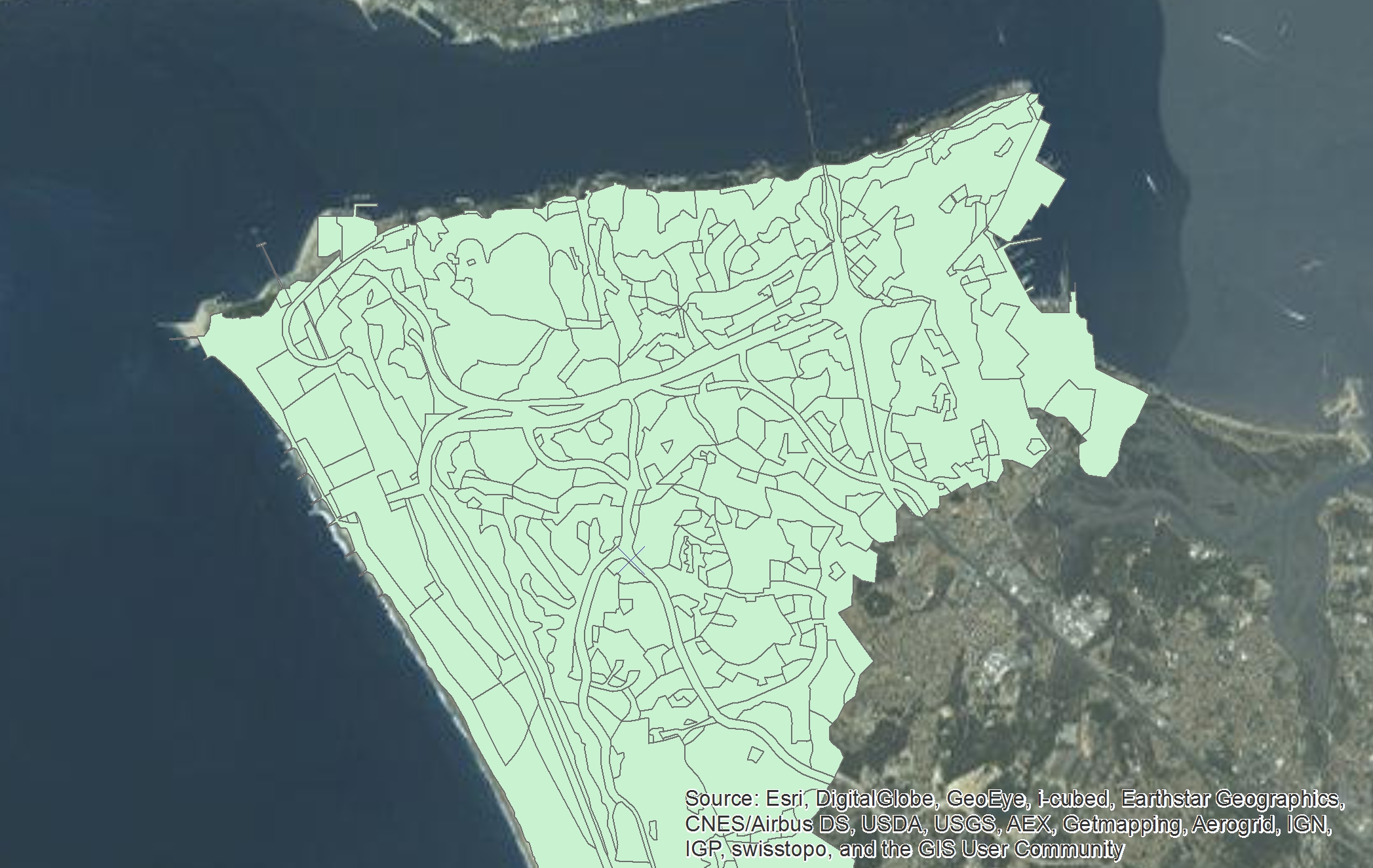
Shape file:
| Projected Coordinate System: | Lisboa_Hayford_Gauss_IGeoE |
| Projection: | Transverse_Mercator |
World Img. Layer:
| Coordinate System: | WGS_1984_Web_Mercator_Auxiliary_Sphere |
| Projection: | Mercator_Auxiliary_Sphere |
When I change the shape file to WGS_1984 then it gets lost in the ocean near Africa.....
- Mark as New
- Bookmark
- Subscribe
- Mute
- Subscribe to RSS Feed
- Permalink
- Report Inappropriate Content
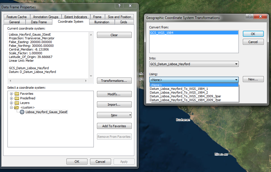
Caitlin, not sure what you mean by change the shp fiel to WGS_1984 but if you are just changing this and not reprojecting the file through one of the ArcGIS toolboxes and the incorrect paramaters are used, this will give you undesired results. If you are unsure about projections and transformations, you can read more about them in the help files within ArcGIS.
Now to help you a little bit more, a lot of times you will need to apply a transformation to your data when working in different coordinate systems. If you go to View>Data Frame properties you will see the window on he left. If you click on the Transformations button, you will then see the window on the right. I am not sure what area of the world you are working on, but in the drop down menu were it says Using: you have some options, try those out and see if that helps your data align better. if that fails, I would have to say it's just data accuracy issues that unfortunately exists when dealing with different sources of data
- Mark as New
- Bookmark
- Subscribe
- Mute
- Subscribe to RSS Feed
- Permalink
- Report Inappropriate Content
i'm still fairly new with ArcGIS so it's possible I am making a really simple mistake. So do I want to transform the current coordinate system which is WGS_1984 into Datum_Lisboa_Hayford (which is the coordinate system of the shape file)? When I make these selections and click apply the current coordinate system stays the same, click ok, still the same and when I reopen it it still says the current coordinate system is WGS_1984. Nothing changes.....
- Mark as New
- Bookmark
- Subscribe
- Mute
- Subscribe to RSS Feed
- Permalink
- Report Inappropriate Content
Ok let's take a step back then. A transformation and a reprojection are two different things.
A transformation in a nutshell you are choosing a mathematical calculation used to convert coordinates referenced to from one datum to coordinates referenced to another datum (see here for an explanation About geographic transformations and how to choose the right one | ArcGIS Blog)
In your case you have two one is the Lisboa and the other is WGS84. In order for things to align, you need to tell ArcGIS which mathematical formula to use to convert the respective coordinates (transformations work both ways i.e it goes from WGS to Lisboa and from Lisboa to WGS) which is what I have mentioned in the post above. Changing this setting will always have our data in their original coordinate systems.
Now if you are looking to have both your shp file and the imagery in WGS84 you need to Reproject your data so that they are both in the same coordinate system. This is done through the Projection toolbox which is pretty self explanitory interms of the parameters to enter. However, you will stil need to find out which transformation applies to your area. Once this step is done both your shp file and the imagery will now have the same coordinate system and if done correctly things should line up.
- Mark as New
- Bookmark
- Subscribe
- Mute
- Subscribe to RSS Feed
- Permalink
- Report Inappropriate Content
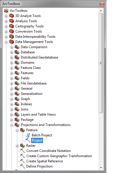
If you need to change the projection of a shapefile, you need to use the Project tool(this will make a new shapefile). If you simply assign it a new coordinate system in properties, you are telling the program this is the projection this data is in(which its not), not projecting it from one coordinate system and datum to another, hence why it ends up in the middle of the ocean.
- Mark as New
- Bookmark
- Subscribe
- Mute
- Subscribe to RSS Feed
- Permalink
- Report Inappropriate Content
Ok, so after projecting it still looks exactly like the original image I posted above only now the coordinate systems match. I still need help figuring out how to get the two layers to line up....