Turn on suggestions
Auto-suggest helps you quickly narrow down your search results by suggesting possible matches as you type.
Cancel
- Home
- :
- All Communities
- :
- Industries
- :
- Transportation
- :
- Transportation Questions
- :
- Zooming to a selected feature and exporting an ima...
Options
- Subscribe to RSS Feed
- Mark Topic as New
- Mark Topic as Read
- Float this Topic for Current User
- Bookmark
- Subscribe
- Mute
- Printer Friendly Page
Zooming to a selected feature and exporting an image - extent issues?
Subscribe
3987
0
07-02-2014 07:44 AM
07-02-2014
07:44 AM
- Mark as New
- Bookmark
- Subscribe
- Mute
- Subscribe to RSS Feed
- Permalink
- Report Inappropriate Content
Hey there,
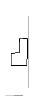
I'm running into a slight issue when attempting to export images of features within a larger project. I've broken down my example to a much more simplistic example for readability. Basically, in this example, I'm attempting to select each feature individually, zoom to it's extent, and export the image to a certain sized image defined by the features attributes. The problem is the extent that I'm receiving from layer.getSelectedExtent() hugs the feature pretty well in some cases, but doesn't do a very good job in other cases.
Now, I can't use data driven pages for this because this snippet is part of a larger project where I have to do more than just the below to get exactly what I want.
Here's my sample code - note, this is an external python script, not run within ArcMap 10.2.1:
Now, if the scale was off in a consistent way, I could multiply the dataFrame's scale by a multiplier to zoom in further, but because the shape of the features are variable, and the scale/extent works great in some cases, I would end up cutting off the features in many of the cases.
Below are some sample images of what's generated:
Bad Extents/Scales:
[ATTACH=CONFIG]35037[/ATTACH]
[ATTACH=CONFIG]35038[/ATTACH]
Good Extents/Scales:
[ATTACH=CONFIG]35040[/ATTACH]
[ATTACH=CONFIG]35039[/ATTACH]
If I open this mxd in ArcMap 10.2.1, I'm able to select these features and zoom to the selected feature just fine and the extent is perfect in ArcMap.
Is there something that I'm missing? Should I need to modify the scale even though I have the selected feature's extent? I might be missing something basic here.
Thanks,
- C
I'm running into a slight issue when attempting to export images of features within a larger project. I've broken down my example to a much more simplistic example for readability. Basically, in this example, I'm attempting to select each feature individually, zoom to it's extent, and export the image to a certain sized image defined by the features attributes. The problem is the extent that I'm receiving from layer.getSelectedExtent() hugs the feature pretty well in some cases, but doesn't do a very good job in other cases.
Now, I can't use data driven pages for this because this snippet is part of a larger project where I have to do more than just the below to get exactly what I want.
Here's my sample code - note, this is an external python script, not run within ArcMap 10.2.1:
import arcpy
# Pixels per inch constant, used in determining the width and height of an image
PPI = 92

# retrieve the mxd, dataframe, and layer I want to export
mxd = arcpy.mapping.MapDocument(r"ExportImages.mxd")
df = arcpy.mapping.ListDataFrames(mxd)[0]
layer = None
layers = arcpy.mapping.ListLayers(mxd)
for lyr in layers:
    if lyr.name.lower() == "layer_i_want":
        layer = lyr
        break

assert(layer != None)

# put the features in an easy to access container
arcpy.SelectLayerByAttribute_management(layer,"CLEAR_SELECTION")
recs = []
with arcpy.da.SearchCursor(layer,"*") as flCursor:
    for flRow in flCursor:
        recDict = {}
        i = 0
        for field in flCursor.fields:
            recDict[field] = flRow
            i += 1
        recs.append(recDict)

for rec in recs:
    print "Generating image for OBJECTID: {0}".format(rec["OBJECTID"])
    query = "OBJECTID = {0}".format(rec["OBJECTID"])
    arcpy.SelectLayerByAttribute_management(layer,"NEW_SELECTION", query)
    #Determine the image width/hight needed based on attribute in feature.
    recWidth = rec["WIDTH"]
    recHeight = rec["HEIGHT"]

    # Convert from feet to inches
    recWidth *= 12
    recHeight *= 12

    # Convert inches to pixels
    recWidth = int(recWidth * PPI)
    recHeight = int(recHeight * PPI)

    # Note - if I change the recWidth/recHeight to larger values, it doesn't change the scale,
    #           it changes the resolution of the image only

    layer.definitionQuery = query
    df.extent = layer.getSelectedExtent()
    arcpy.mapping.ExportToPNG(mxd, r"C:\temp\{0}.png".format(rec["OBJECTID"]), df, recWidth, recHeight)
    layer.definitionQuery = ""
Now, if the scale was off in a consistent way, I could multiply the dataFrame's scale by a multiplier to zoom in further, but because the shape of the features are variable, and the scale/extent works great in some cases, I would end up cutting off the features in many of the cases.
Below are some sample images of what's generated:
Bad Extents/Scales:
[ATTACH=CONFIG]35037[/ATTACH]
[ATTACH=CONFIG]35038[/ATTACH]
Good Extents/Scales:
[ATTACH=CONFIG]35040[/ATTACH]
[ATTACH=CONFIG]35039[/ATTACH]
If I open this mxd in ArcMap 10.2.1, I'm able to select these features and zoom to the selected feature just fine and the extent is perfect in ArcMap.
Is there something that I'm missing? Should I need to modify the scale even though I have the selected feature's extent? I might be missing something basic here.
Thanks,
- C
0 Replies